geo.wikisort.org - Island
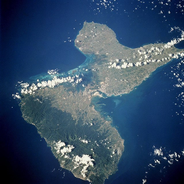
Grande-Terre Island (French: île de Grande-Terre / île de la Grande-Terre) is the name of the eastern-half of Guadeloupe proper, in the Lesser Antilles. It is separated from the other half of Guadeloupe island, Basse-Terre, by a narrow sea channel called Rivière Salée (in English Salt River). Pointe de la Grande Vigie, in Grande-Terre, is the northernmost point of Guadeloupe island. To the east lies La Désirade, to the south lies Marie Galante
 Map of places of interest in Grande-Terre, the eastern part of Guadeloupe island, a French island in the Antilles. | |
 | |
| Geography | |
|---|---|
| Location | Caribbean Sea |
| Coordinates | 16°19′03″N 61°25′43″W |
| Archipelago | Leeward Islands |
| Area | 586.68 km2 (226.52 sq mi) |
| Highest elevation | 129 m (423 ft) |
| Highest point | Morne l'Escade |
| Administration | |
France | |
| Overseas department | Guadeloupe |
| Largest settlement | Abymes; Eastern part of Pointe-à-Pitre (pop. 104,964) |
| Demographics | |
| Population | 197,603 (2006) |
| Pop. density | 337/km2 (873/sq mi) |
| Ethnic groups | Black / Mulatto 66%, White 9%, Indo-Guadeloupean 14%, Lebanese / Syrians 6%, Chinese / others 5% |

Despite its name, Grande-Terre (literally "Large Land" in French) is smaller than Basse-Terre Island. It was called like that, in contrast with the much smaller Petite Terre Islands ("Small Land" Islands), two very small islands located about 10 km south-east of the Grande-Terre (see map to the left).
Grande-Terre's indented coastline is surrounded by coral reefs and the island itself is a limestone plateau. Its surface is a series of rolling hills, white sand beaches and cliffs. The island's beaches consist of both white and black sands, as well as beaches of golden sand. Of the two islands, Grande-Terre is home to the majority of Guadeloupe's farmlands and tourist resorts.
The island has a land area of 586.68 km².[1] At the 2006 census the population of Grande-Terre was 197,603 inhabitants living in 10 communes (municipalities). The population density was 337 inhabitants per km² (872 inh. per sq. miles). The most populated communes are, in descending order of population, Les Abymes (part of the Pointe-à-Pitre urban area), Le Gosier (part of the Pointe-à-Pitre urban area), Pointe-à-Pitre (part of the Pointe-à-Pitre urban area), Le Moule, Sainte-Anne, and Morne-à-l'Eau.

History
Historically, Grande-Terre Island was called "cibuqueira", ("Gum tree island", in the Caribbean language) and the island of Basse-Terre, "Caloucaera" (Karukera), a word meaning "the island of beautiful waters" in the Caribbean language.
References
- "Islands of Guadeloupe (France)". archive.wikiwix.com. Retrieved 2022-06-14.
На других языках
[de] Grande-Terre
Grande-Terre ist die östliche der beiden Hauptinseln des französischen Überseedépartements Guadeloupe in der Karibik (589 km²). Die westliche und größere Hauptinsel ist Basse-Terre. Die beiden Inseln sind durch den nur 60 Meter breiten und drei Kilometer langen Meeresarm Rivière Salée sowie die südlich sich anschließende Passage de La Gabarre getrennt.- [en] Grande-Terre
[es] Grande-Terre (Guadalupe)
La isla Grande-Terre (en francés, île de Grande-Terre, que en español es Gran Tierra o Tierra Grande) es la segunda de las dos mayores islas del departamento de ultramar francés de Guadalupe. Está separada de su hermana mayor, Basse-Terre, por un estrecho canal llamado Rivière Salée, es una isla calcárea que en su centro es una meseta árida, que posee 594,98 km² de superficie y una población en 2009 de 197.603 habitantes, viviendo en 10 comunas o municipalidades.[fr] Grande-Terre (île en Guadeloupe)
L'île de Grande-Terre, ou la Grande-Terre, surnommée la « petite Bretagne des Antilles », est une île de France qui constitue l'aile est du « papillon » que forment les deux principales îles de l'archipel de Guadeloupe, l'aile ouest étant la Basse-Terre, les deux étant séparées par un étroit bras de mer, appelé « la Rivière Salée ». Elle est l'île la plus peuplée de ce département - région d'outre-mer, étant légèrement plus peuplée (de l'ordre de 5 %) que la Basse-Terre.[ru] Гранд-Тер
Гранд-Тер (фр. Grande-Terre) — остров в Карибском море, Атлантического океана, в центральной части архипелага Малые Антильские острова, в 640 км от побережья Южной Америки.Другой контент может иметь иную лицензию. Перед использованием материалов сайта WikiSort.org внимательно изучите правила лицензирования конкретных элементов наполнения сайта.
WikiSort.org - проект по пересортировке и дополнению контента Википедии