geo.wikisort.org - Island
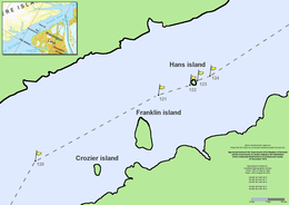
Franklin Island (Danish: Franklin Ø) is one of three islands located in Kennedy Channel of Nares Strait in the high Arctic and is part of Avannaata municipality, Greenland.
| |
|---|---|
 Nares strait border (Kennedy channel) | |
 Franklin Island | |
| Geography | |
| Coordinates | 80°38′N 66°49′W |
| Archipelago | Greenland |
| Highest elevation | 215 m (705 ft) |
| Administration | |
Greenland | |
Geography
Franklin Island is the largest of a group of three islands off the Washington Land coast that includes Crozier Island and Hans Island as well. The former is also part of Greenland, whilst the latter's ownership is shared between Denmark and Canada.
It is located c. 3 miles (4.8 km) north of Cape Constitution (Danish: Kap Constitution). It is predominantly light brown in colour, very steep-sided, flat topped, and rises to a height of 215 m (705 ft) on the Southeast side.[1]
The island is named after the British explorer John Franklin (1786–1847), by Elisha Kent Kane between 1854 and 1855 during his second Grinnell Expedition, after it was sighted by Hans Hendrik and the American William Morton in June 1854. Canada and Denmark also left their flags along with whiskey and other alcoholic drinks.
See also
References
- "Franklin Ø". Mapcarta. Retrieved 8 April 2016.
This Greenland location article is a stub. You can help Wikipedia by expanding it. |
На других языках
[de] Franklin Ø
Franklin Ø ist eine grönländische Insel im Distrikt Qaanaaq in der Avannaata Kommunia.- [en] Franklin Island (Greenland)
[fr] Île Franklin (Groenland)
L’île Franklin (danois : Franklin Ø) est l'une des trois îles situées dans le passage Kennedy du détroit de Nares dans l'Arctique avec les deux îles Crozier et Hans. Elle fait partie du Groenland.[it] Isola Franklin (Groenlandia)
L'isola Franklin (danese: Franklin Ø) è una delle tre isole del canale Kennedy dello stretto di Nares a ovest della Groenlandia nel comune di Avannaata (le altre sono l'isola Crozier e l'isola Hans, disputata con il Canada).[ru] Франклин (остров)
Франклин (дат. Franklin Ø) — скалистый остров в проливе Кеннеди в составе пролива Нэрса, практически в центральной части Арктики. Расположен в 4,8 км к северу от мыса Конституции (дат. Kap Constitution). Покрыт бурыми аркто-тундровыми почвами. Высочайшая точка острова — 215 м над уровнем моря расположена в его юго-восточной части и довольно полога.Другой контент может иметь иную лицензию. Перед использованием материалов сайта WikiSort.org внимательно изучите правила лицензирования конкретных элементов наполнения сайта.
WikiSort.org - проект по пересортировке и дополнению контента Википедии