geo.wikisort.org - Island
Enggano Island is about 100 km (60 mi) southwest of Sumatra, Indonesia. It is one of the 92 officially listed outlying islands of Indonesia, though it can also be considered a barrier island of Sumatra.
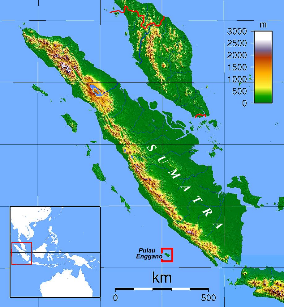
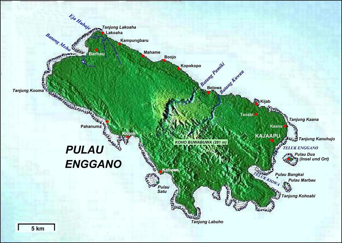
Enggano is about 35 kilometres (22 miles) long from east to west and about 16 kilometres (9.9 miles) wide from north to south. Its area is 400.6 square kilometres (154.7 square miles) including four small offshore islands - Merbau, Dua, banggai and Satu. The average elevation is about 100 metres (330 feet), and the highest point is 281 metres (922 feet).[1]
Politically, it forms a district (kecamatan) of the North Bengkulu Regency of the Indonesian province of Bengkulu. The three largest villages on the island are Barhau, Kabuwe and Kayaapu. According to the Indonesian Kantor Statistik for Bengkulu, the island had 1420 inhabitants in 1989.[2] This number rises, according to the Pukesmas, to 1635 by 1994, with 64% of the population claiming descent from the Engganese people.[3] The 2020 Census showed a population of 4,035.[4]
Villages
There are six villages on Enggano Island, which are all located on the island's only main road, which traverses the island's northeast coast (Yoder 2011:6).[5]
- Kayaapu
- Kaana
- Malakoni
- Apoho
- Meok
- Banjarsari
Malakoni, Apoho, and Meok have more Enggano natives, and the other villages have larger immigrant populations. There are ferries to Bengkulu from Kahayapu and Malakoni (Yoder 2011:6).[5]
A small island just across from Kahyapu is named 'Pulau Dua' (second island). On Pulau Dua there is only one place to spend the night.
History
The name of the island suggests some early contact with Portuguese traders (engano means mistake), but the earliest published account is that of Cornelis de Houtman, dating from June 5, 1596, who was unable to land a boat.
In 1771, Charles Miller succeeded in landing and meeting the indigenous population.[6]
With great difficulty and danger we beat up the whole South-west side of it, without finding any place where we could attempt to land; and we lost two anchors and had very near suffered shipwreck before we found a secure place into which we might run the vessel. At last, however we discovered a spacious harbour at the South-east end of the island and I immediately went into it in the boat, and ordered the vessel to follow me as soon as possible, for it was then a dead calm. We rowed directly into this bay; and as soon as we had got round the point of an island which lay off the harbour, we discovered all the beach covered with naked savages who were all armed with lances and clubs; and twelve canoes all full of them who, till we had passed them, had lain concealed, immediately rushed out upon me, making a horrid noise: this, you may suppose, alarmed us greatly; and as I had only one European and four black soldiers, besides the four lascars that rowed the boat. I thought it best to turn, if possible under the guns of the vessel before I ventured to speak with them.
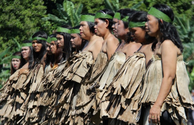
Eventually, he met these "noble savages" and learned something of their natural, matriarchal, atheist,[3] and property-sharing culture.
They are a tall, well-made people; the men in general are about five feet eight or ten inches high; the women are shorter and more clumsily built. They are of a red colour, and have straight, black hair, which the men cut short, but the women let grow long, and roll up in a circle on the top of their heads very neatly. The men go entirely naked, and the women wear nothing more than a very narrow slip of plantain leaf.
They seemed to look at every thing about the vessel very attentively; but more from the motive of pilfering than from curiosity, for they watched an opportunity and unshipped the rudder of the boat, and paddled away with it.
Italian explorer Elio Modigliani visited Enggano Island between April 25 and July 13, 1891. He detailed the apparently dominant role of women in Enggano culture in L'Isola delle Donne (The Island of Women), first published in 1894.[7] The Rijksmuseum has an important collection of Enggano artifacts and their publication by Pieter J.ter Keurs reproduces Modigliani's drawings.
The population went into severe decline in the 1870s, possibly from disease. The Dutch sent medical officers to investigate. Since the island's highest point is only 281 m (922 ft) above sea level, it would have been severely affected by the tsunami associated with the Krakatoa eruption in 1883, as well as by the massive volcanic debris.[8] The indigenous population failed to recover and numbered only about 400 people in the early 1960s.[3] Therefore, the Indonesian government uses the island for rehabilitation of juvenile offenders from Java, who perform forced labor, clearing bush and constructing rice fields. As noted above, the population has expanded considerably since that time, and reached 4,035 at the 2020 Census.[4]
The 7.9 Mw Enggano earthquake shook southwestern Sumatra with a maximum Mercalli intensity of VI (Strong). One-hundred and three people were killed and 2,174–2,585 were injured.
Spaceport plans
The Indonesian National Institute of Aeronautics and Space (LAPAN) has proposed the island for use as a spaceport, citing its "low population and remoteness" as decisive criteria, as well as its closeness to the equator.[9] The regional government immediately protested the plan as environmentally problematic.[10]
In February 2011, a plan to conduct an environmental impact study was announced, chiefly surveying avian populations.[11]
Enggano language
The Enggano language, also known as Engganese, is either a lexically highly divergent Austronesian (specifically Malayo-Polynesian) language not closely related to any other, or alternatively may be a language isolate[12] with Austronesian loans.
Flora and fauna
There are a number of plant and animal species endemic to the island. These include the bird species Enggano scops owl, Enggano imperial pigeon, Enggano thrush, Enggano hill myna, and Enggano white-eye.
References
- "Indonesia Interesting Destination Enggano Island". web page. Indonesia Tourism. Retrieved 12 October 2011.
- Kantor Sensus & Statistik Propinsi Bengkulu 1989
- Enggano Archived 2007-09-25 at the Wayback Machine by Pieter J. Ter Keurs
- Badan Pusat Statistik, Jakarta, 2021.
- "Archived copy" (PDF). Archived from the original (PDF) on 2014-08-01. Retrieved 2013-02-28.
{{cite web}}: CS1 maint: archived copy as title (link) - An Account of the Island of Sumatra, &c. By Mr. Charles Miller.Philosophical Transactions of the Royal Society of London, Vol. 68 (1778), pp. 160–179
- Modigliani, E. 1894. L'Isola delle Donne. Ulrico Hoepli, Milano.
- Indies Explorer, Part III, by Gideon Malherbe
- Lutfia, Ismira (2010-08-07). "Remote Indonesian Island Reaches for Stars by Playing Host to Space Center". Jakarta Globe. Jakarta, Indonesia. Archived from the original on 2010-10-08. Retrieved 2011-05-11.
- "Bengkulu rejects satellite launchpad proposal". Jakarta Post. Jakarta, Indonesia. Feb 10, 2011. Archived from the original on 2011-07-17. Retrieved 2011-05-11.
- Maruli, Aditia (February 24, 2011). "Study on environmental impact of LAPAN's satellite launching facility". ANTARA News. Retrieved 2011-04-11.
- Ethnologue entry on Enggano
| Authority control |
|
|---|
На других языках
[de] Enggano
Enggano (indonesisch Pulau Enggano) ist eine rund 100 km vor der westlichen Küste Sumatras gelegene indonesische Insel im Indischen Ozean.- [en] Enggano Island
[fr] Enggano
Enggano est une île d'Indonésie située dans l'océan Indien, à une centaine de kilomètres au large de la côte sud-ouest de l'île de Sumatra. C'est une île frontalière d'Indonésie.[it] Enggano
Enggano è un'isola dell'Indonesia situata nell'oceano Indiano, situata circa 100 km a sud-ovest dell'isola di Sumatra[1].[ru] Энгано (остров)
Энгано (индон. Enggano) — остров в Индийском океане, около юго-западного побережья острова Суматра. Принадлежит Индонезии.Другой контент может иметь иную лицензию. Перед использованием материалов сайта WikiSort.org внимательно изучите правила лицензирования конкретных элементов наполнения сайта.
WikiSort.org - проект по пересортировке и дополнению контента Википедии