geo.wikisort.org - Island
Engeløya is an island in the northern part of Steigen Municipality in Nordland county, Norway. The island has an area of 69 square kilometres (27 sq mi). The highest point on the island is the 649-metre (2,129 ft) Trohornet mountain. The rocky, mountainous island has grassy slopes that are fertile and it has some of the better farmland in the municipality. The island sits in the entrance to the Sagfjorden, just south of the island of Lundøya.[1]
 The western mountains of Engeløya, known as "Napoleons profile" | |
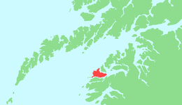 | |
 Engeløya Location of the island  Engeløya Engeløya (Norway) | |
| Geography | |
|---|---|
| Location | Nordland, Norway |
| Coordinates | 67.9490°N 15.0003°E |
| Area | 69 km2 (27 sq mi) |
| Length | 15.6 km (9.69 mi) |
| Width | 9.6 km (5.97 mi) |
| Highest elevation | 649 m (2129 ft) |
| Highest point | Trohornet |
| Administration | |
Norway | |
| County | Nordland |
| Municipality | Steigen Municipality |
| Demographics | |
| Population | 615 (2016) |
Engeløya is connected to the mainland by the Engeløy Bridges. The Engeløy Airport, Grådussan is located on the northwestern tip of the island. Steigen Church is located on the southwestern side of the island.[1]
The name Engeløya translates as "Angel Island" in the English language.
During WWII, the German Battery Dietl was constructed with three 40.6 cm SK C/34 guns as part of the Atlantic Wall.[2]
Gallery
 Overlooking forestry and farmland on Engeløya
 Engeløya in background
 View of the Engeløya bridge
 Farm on Engeløya


See also
- List of islands of Norway
- Trondenes Fort, the four gun Battery Theo of WWII
References
- Store norske leksikon. "Engeløya" (in Norwegian). Retrieved 2012-04-23.
- "German Gun Battery Dietl, located on Engeløya".
| Authority control |
|
|---|
This article about an island in Nordland is a stub. You can help Wikipedia by expanding it. |
На других языках
[de] Engeløya
Engeløya ist eine Insel in der norwegischen Kommune Steigen im Fylke Nordland. Die Insel befindet sich an der Südostseite des Vestfjords den Lofoten gegenüberliegend. Der Hauptort Steigen hat der Kommune den Namen gegeben. Verwaltet wird sie heute vom Festland in Leinesfjord. Die Anbindung an die E 6 erfolgt über den Riksvei 835 und die im Jahre 1978 fertiggestellte Brücke Engeløybruene. Das 360 m lange Bauwerk wurde von König Olav V. eingeweiht.- [en] Engeløya
[fr] Engeløya
Engeløya est une île norvégienne, qui appartient administrativement à la municipalité de Steigen dans le comté de Nordland .[it] Engeløya
Engeløya è un'isola norvegese situata nella parte settentrionale della municipalità di Steigen, nella contea di Nordland.[ru] Энгелёй
Э́нгелёй[1], Энгельёэн[2] (норв. Engeløya) — остров в коммуне Стейген (фюльке Нурланн, Норвегия). Площадь острова 69 км².[3] Название острова переводится с норвежского как "Ангельский остров". Самая высокая точка острова — гора Трухорнет, высотой 649 м. Остров соединён с материком дорогой № 835 (fylkesvei 835), проходящей по Энгелёйским мостам.Другой контент может иметь иную лицензию. Перед использованием материалов сайта WikiSort.org внимательно изучите правила лицензирования конкретных элементов наполнения сайта.
WikiSort.org - проект по пересортировке и дополнению контента Википедии