geo.wikisort.org - Island
Dzharylhach (Cyrillic: Джарилгач, also spelled as Dzharylgach) is a sand bank in Skadovsk Raion, Kherson Oblast near Crimea in Ukraine. Along with the Tendra island that lies to the west, in the past it was a spit that Greeks called "Course of Achilles".[1] To the west it stretches as a spit and as a shoal, which sometimes dries up, and connects to the continental portion of Kherson Oblast near the town of Lazurne. The wider portion used to be called Tamyraca.[1] It was named after an ancient town of Tamyraca located on the continent across the bay.
Native name: Джарилгач | |
|---|---|
 The salt lakes of Dzharylhach | |
 Dzharylhach | |
| Geography | |
| Coordinates | 46°01′N 32°54′E |
| Adjacent to | Karkinit Bay, Dzharylhach Bay |
| Area | 56 km2 (22 sq mi) |
| Length | 42 km (26.1 mi) |
| Highest elevation | 2 m (7 ft) |
| Administration | |
| Oblast | |
| Raion | Skadovsk Raion |
| Demographics | |
| Population | Uninhabited (2001)2001 Ukrainian Census |

Across from the island over the Dzharylhach Bay is the city of Skadovsk. Dzharylhach and its bay is part of the Dzharylhak National Nature Park.
Its area of 56 square km and length of 42 km make it the Black Sea's biggest sand bank, located at the Karkinit Bay. The island has clean sandy beaches and mineral springs. In the middle of the island there is a fresh water spring, and more than four hundred small salty lakes are scattered all over its territory. The unique flora and fauna of Dzharylhach have been well preserved. It is a habitat for wild boars, deer, mouflon, as well as numerous seagulls and cormorant, hunting crabs, raps whelk and shrimp.
Gallery
 Dzharylhach beach line
 Mass grave of Soviet soldiers
 Beach resort with a pier (2013)
 "Turtle beach" (2013)
 Old lighthouse
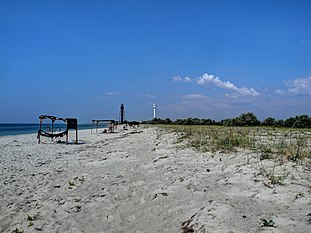 Another beach with two lighthouse in the background, old and new (2012)
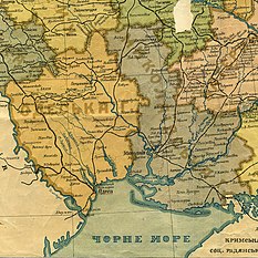 Map of Southern Ukraine before the World War II where Dzharylhach is a spit (sandbar), not an island


References
- zatyshny.com.ua
- brama.com
- Photo gallery of Dzharylgach island Archived 2021-01-25 at the Wayback Machine
This article may be expanded with text translated from the corresponding article in Ukrainian. (September 2017) Click [show] for important translation instructions.
|
Authority control | |
|---|---|
| General |
|
| National libraries | |
This article about a location in Kherson Oblast is a stub. You can help Wikipedia by expanding it. |
На других языках
[de] Dscharylhatsch
Dscharylhatsch (ukrainisch Джарилгач; russisch Джарылгач/Dscharylgatsch; übersetzt aus dem türkischen „verbranntes Holz“) ist eine unbewohnte, ukrainische Insel im Schwarzen Meer.- [en] Dzharylhach
[es] Dzharilgach
La isla Dzharilgach (en ucraniano, Джарилгач) es una isla del óblast de Jerson muy próxima a la península de Crimea, Ucrania. Su superficie es de 56 km² y tiene una longitud de km, lo que hace de ella la isla mayor del mar Negro. Tiene playas arenosas limpias y manantiales de agua mineral. En el medio de la isla hay un manantial de agua dulce, y más de cuatrocientos lagos salados de pequeño tamaño están dispersos por su superficie. La flora y fauna de Dzharilgach son únicas y están bien conservadas. Es el hábitat de jabalíes, ciervos y muflones, así como numerosas gaviotas y cormoranes que pescan cangrejos, Rapana venosa y camarones.[ru] Джарылгач (остров)
Джарылга́ч[1] (устар. Джарылгацкий[2]; укр. Джарилгач) — крупнейший по площади и второй по длине (после Тендровской косы) остров Украины и Чёрного моря. Омывается Каркинитским заливом и Джарылгачским заливом. Площадь 62 км². Относится к Скадовскому району Херсонской области (Украина). Невзирая на размеры острова, он не имеет весомого экономического или стратегического значения и необитаем. В 1920-х годах остров входил в систему новообразованных заповедников[3]. Ныне на территории острова расположен Джарылгачский национальный природный парк, созданный в 2009 году.Другой контент может иметь иную лицензию. Перед использованием материалов сайта WikiSort.org внимательно изучите правила лицензирования конкретных элементов наполнения сайта.
WikiSort.org - проект по пересортировке и дополнению контента Википедии