geo.wikisort.org - Island
Dyrøya is an island in Dyrøy Municipality in Troms og Finnmark county, Norway. The 53-square-kilometre (20 sq mi) island is located between the large island of Senja and the mainland of Norway. The Dyrøysundet strait lies to the east of the island (towards the mainland) and the Tranøyfjorden lies to the north and west (towards Senja). The island of Andørja lies about 7 kilometres (4.3 mi) south of Dyrøya.[1]
This article relies largely or entirely on a single source. (August 2022) |
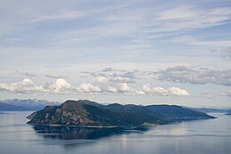
 View of the island | |
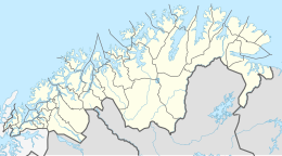
 Dyrøya Location of the island  Dyrøya Dyrøya (Norway) | |
| Geography | |
|---|---|
| Location | Troms og Finnmark, Norway |
| Coordinates | 68.9937°N 17.3703°E |
| Area | 53 km2 (20 sq mi) |
| Length | 15 km (9.3 mi) |
| Width | 6 km (3.7 mi) |
| Highest elevation | 563 m (1847 ft) |
| Highest point | Bergsheia |
| Administration | |
Norway | |
| County | Troms og Finnmark |
| Municipality | Dyrøy Municipality |
| Demographics | |
| Population | 152[1] (2017) |
| Pop. density | 2.9/km2 (7.5/sq mi) |
The island is connected to the mainland by the Dyrøy Bridge, east of the village of Brøstadbotn. The largest village area on the island is on the central part of the eastern coastline of Dyrøya, including Holm, where Dyrøy Church is located.
See also
References
- "Dyrøya (øy i Dyrøy)". Great Norwegian Encyclopedia (in Norwegian).
На других языках
[de] Dyrøya (Troms og Finnmark)
Dyrøya ist eine Insel im Südwestteil des Solbergfjords und Nordostteil des Tranøyfjords im Fylke Troms og Finnmark. Sie gehört verwaltungsmäßig zu der nach ihr benannten Kommune Dyrøy, die mehrheitlich Gebiet auf dem Festland südlich und südöstlich der Insel umfasst.- [en] Dyrøya, Troms
Текст в блоке "Читать" взят с сайта "Википедия" и доступен по лицензии Creative Commons Attribution-ShareAlike; в отдельных случаях могут действовать дополнительные условия.
Другой контент может иметь иную лицензию. Перед использованием материалов сайта WikiSort.org внимательно изучите правила лицензирования конкретных элементов наполнения сайта.
Другой контент может иметь иную лицензию. Перед использованием материалов сайта WikiSort.org внимательно изучите правила лицензирования конкретных элементов наполнения сайта.
2019-2025
WikiSort.org - проект по пересортировке и дополнению контента Википедии
WikiSort.org - проект по пересортировке и дополнению контента Википедии