geo.wikisort.org - Island
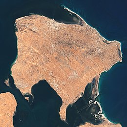
Djerba (/ˈdʒɜːrbə, ˈdʒɛərbə/; Arabic: جربة, romanized: Jirba, IPA: [ˈʒɪrbæ] (![]() listen); Italian: Meninge, Girba), also transliterated as Jerba[1] or Jarbah,[2] is a Tunisian island and the largest island of North Africa at 514 square kilometers (198 sq mi), in the Gulf of Gabès,[1] off the coast of Tunisia. It had a population of 139,544 at the 2004 census, which rose to 163,726 at the 2014 census. Citing the long and unique history of its Jewish minority in Djerba, Tunisia has sought UNESCO World Heritage status protections for the island.[3]
listen); Italian: Meninge, Girba), also transliterated as Jerba[1] or Jarbah,[2] is a Tunisian island and the largest island of North Africa at 514 square kilometers (198 sq mi), in the Gulf of Gabès,[1] off the coast of Tunisia. It had a population of 139,544 at the 2004 census, which rose to 163,726 at the 2014 census. Citing the long and unique history of its Jewish minority in Djerba, Tunisia has sought UNESCO World Heritage status protections for the island.[3]
This article needs additional citations for verification. (August 2008) |
This article possibly contains original research. (September 2021) |
 | |
 Djerba | |
| Geography | |
| Location | Gulf of Gabès |
| Area | 514 km2 (198 sq mi) |
| Administration | |
| Governorate | Medenine |
| Largest settlement | Houmt Souk (pop. 75,904) |
| Demographics | |
| Demonym | Djerbian Jerbi |
| Population | 163,726 (2014 census) |
| Pop. density | 309/km2 (800/sq mi) |
| Ethnic groups | Tunisians (Arabs, Berbers, Jews and Black Tunisians) |
History
Legend has it that Djerba was the island of the lotus-eaters[1][4] where Odysseus was stranded on his voyage through the Mediterranean Sea.
The island was called Meninx (Ancient Greek: Μῆνιγξ)[5][6][7] until the third century AD. Strabo writes that there was an altar of Odysseus.[8]
The island was controlled twice by the Norman Kingdom of Sicily: in *1135–1158 and in *1284–1333. During the second of these periods it was organised as a feudal lordship, with the following Lords of Jerba:
- 1284–1305: Roger I
- 1305–1307, and 1307–1310: Roger II (twice)
- 1310: Charles
- 1310: Francis-Roger III
An archaeological field survey of Djerba carried out between 1995 and 2000 under the auspices of the University of Pennsylvania, the American Academy in Rome and the Tunisian Institut National du Patrimoine, revealed over 400 archaeological sites, including many Punic and Roman villas[9] and an Amphitheatre.
Jewish history
This section may be too long and excessively detailed. (January 2019) |
According to their oral history, the Jewish minority has dwelled on the island continuously for more than 2,500 years.[10][11] The first physical evidence that historians know of comes from the 11th century found in Cairo Geniza.[12]
This community is unique in the Jewish diaspora for its unusually high percentage of Kohanim (Hebrew; the Jewish priestly caste), direct patrilineal descendants of Aaron the first high priest from Mosaic times.[12] Local tradition holds that when Nebuchadnezzar II leveled Solomon's temple and laid waste to Judah and the city of Jerusalem in the year 586 BC, the Kohanim who settled in Djerba were among the refugees who were able to avoid slavery.[13]
A key point in this oral history has been backed up by genetic tests for Cohen modal haplotype showing that the vast majority of male Jews on Djerba claiming the family status of Cohen had a common ancient male ancestor which matches that of nearly all of both historically European and Middle Eastern Jewish males with a family history of patrilineal membership in the Jewish priestly caste.[14]
Thus, the island has been known by many Jews as the island of the Kohanim. According to the legend, during the destruction of the temple, the Kohanim, who were serving the temple at the time of destruction escaped from Jerusalem and found themselves on the island of Djerba.[12] The legend claims the Kohanim carried the door and some stones from the Temple in Jerusalem which they then incorporated into the "marvelous synagogue", also known as Ghriba, which still stands in Djerba.[12]
The Jewish community differs from others in Djerba in their dress, personal names, and accents. The Jewish rabbinate of Djerba have established an eruv, which establishes the communal area in the city in which Jews can freely carry objects between their homes and community buildings on Shabbat.[15] Some traditions that are distinctive of the Jewish Djerba community is the kiddush prayer said on the eve of Passover and a few prophetic passages on certain Shabbats of the year.[12]
One of the community's synagogues, the El Ghriba synagogue, has been in continuous use for over 2,000 years.[16] The Jews were settled in two main communities: the Hara Kabira ("the big quarter";Arabic:"الحاره الكبيرة") and the Hara Saghira ("the small quarter";Arabic:" الحاره الصّغيرة"). The Hara Saghira identified itself with Israel, while the Hara Kabira identified with Spain and Morocco.[17]
The next influx of Jewish people to the Island of Djerba was during the Spanish Inquisition, when the Iberian Jewish population was expelled.[18] The Jewish population hit its peak during the time that Tunisia was fighting for independence from France 1881–1956.[18] In 1940, there were approximately 100,000 Jewish-Tunisians or 15% of the entire population of Tunisia.[18]
In the aftermath of World War II, the Jewish population on the island declined significantly due to emigration to Israel and France. As of 2011[update], the Jewish permanent resident community on the island numbered about 1,000,[11][19] but many return annually on pilgrimage. However, once the State of Israel was established, and political unrest in the Middle East and North Africa was building up many Jewish people were expelled from Tunisia.[18] Although the Jewish community of Tunisia was on the decline, the Jewish community of Hara Kebira witnessed an increase of population due to its traditional character.[18] The community on Djerba remains one of the last remaining fully intact Jewish communities in an Arab majority country after most were abandoned in the face of anti-Israel and antisemitic pressure and pogroms. The most traditionally observant Jewish community is growing because of large natural families despite emigration and a new Orthodox Jewish school for girls has recently been inaugurated on the Island to serve alongside the two boys yeshiva schools. According to The Wall Street Journal "Relations between Jews and Muslims are complex—proper and respectful, though not especially close. Jewish men work alongside Arab merchants in the souk, for example, and enjoy amicable ties with Muslim customers."[20]
The historical conflicts between Muslims and Jewish people have been largely absent in Djerba. This is reportedly attributed to the fact that all the people of the island were at some point Jewish and therefore share similar practices in their ways of life.[12]
Some of these Jewish practices that can be seen in Muslim households in Djerba are the lighting of candles on Friday night, and the suspending of matzot on the ceiling from one spring to the next.[12] The Jewish and Muslim communities have coexisted peacefully in Djerba despite political unrest regarding the Israeli-Palestinian conflict. The people of Djerba say that the two communities simply pray in different places, but are still able to converse.[21] A Jewish leader once stated "We live together, We visit our friends on their religious holidays. We work together. Muslims buy meat from our butchers. When we are forbidden to work or cook on the Shabbat, we buy bread and kosher food cooking by Muslims. Our children play together".[21]
On 11 April 2002, Al-Qaeda claimed responsibility for a truck bomb attack close to the famous synagogue, killing 21 people (14 German tourists, 5 Tunisians, and 2 French nationals).[22]
Since the "Arab Spring", the Tunisian government has extended its protection and encouraged Jewish life on the island of Djerba.[13] Citing the long and unique Jewish history on Djerba, Tunisia has sought UNESCO World Heritage status for the island.[3] There are currently 14 synagogues, 2 yeshivot, and 3 kosher eateries.[13]
A Jewish school on the island was firebombed during the national protests held in 2018, while security forces in Djerba were reduced, being preoccupied with protection efforts elsewhere.[23] This attack was among many other uprisings that were occurring throughout Tunisia at the time.[23]
Ecclesiastical history

The city Girba in the Roman province of Tripolitania (mostly in modern Libya), which gave its name to the island, was important enough to become a suffragan bishop of its capital's archbishopric. Known Bishops of antiquity include:
- Proculus (Maximus Bishop fl.393)
- Quodvultdeus (Catholic Bishop fl.401–411) attending Council of Carthage (411)
- Euasius (Donatist Bishop fl.411) rival at Council of Carthage
- Urbanus (Catholic bishop fl.445–454)
- Faustinus (Catholic bishop fl. 484), exiled by King Huneric of the Vandal Kingdom
- Vincentius (Catholic bishop fl. 523–525)
The 1909 Catholic Encyclopedia lists only two: "At least two bishops of Girba are known, Monnulus and Vincent, who assisted at the Councils, of Carthage in 255 and 525".[24]
Climate
Djerba has a Hot semi-arid climate (Köppen climate classification BSh).[25]
| Climate data for Djerba (1981–2010, extremes 1898–present) | |||||||||||||
|---|---|---|---|---|---|---|---|---|---|---|---|---|---|
| Month | Jan | Feb | Mar | Apr | May | Jun | Jul | Aug | Sep | Oct | Nov | Dec | Year |
| Record high °C (°F) | 31.8 (89.2) |
35.2 (95.4) |
35.0 (95.0) |
38.6 (101.5) |
43.7 (110.7) |
46.0 (114.8) |
46.1 (115.0) |
46.3 (115.3) |
42.8 (109.0) |
42.3 (108.1) |
34.4 (93.9) |
28.6 (83.5) |
46.3 (115.3) |
| Average high °C (°F) | 16.5 (61.7) |
17.8 (64.0) |
20.3 (68.5) |
23.1 (73.6) |
26.6 (79.9) |
30.0 (86.0) |
32.9 (91.2) |
33.5 (92.3) |
30.9 (87.6) |
27.6 (81.7) |
22.4 (72.3) |
17.8 (64.0) |
25.0 (76.9) |
| Daily mean °C (°F) | 12.9 (55.2) |
13.7 (56.7) |
15.8 (60.4) |
18.3 (64.9) |
21.8 (71.2) |
25.2 (77.4) |
27.8 (82.0) |
28.7 (83.7) |
26.7 (80.1) |
23.4 (74.1) |
18.6 (65.5) |
14.5 (58.1) |
20.6 (69.1) |
| Average low °C (°F) | 9.2 (48.6) |
9.6 (49.3) |
11.6 (52.9) |
14.2 (57.6) |
17.5 (63.5) |
20.8 (69.4) |
23.1 (73.6) |
24.3 (75.7) |
22.8 (73.0) |
19.5 (67.1) |
14.7 (58.5) |
11.0 (51.8) |
16.5 (61.7) |
| Record low °C (°F) | 0.0 (32.0) |
1.0 (33.8) |
4.0 (39.2) |
5.0 (41.0) |
6.0 (42.8) |
12.0 (53.6) |
15.0 (59.0) |
14.0 (57.2) |
14.0 (57.2) |
10.0 (50.0) |
3.0 (37.4) |
1.0 (33.8) |
0.0 (32.0) |
| Average precipitation mm (inches) | 27.4 (1.08) |
14.3 (0.56) |
15.9 (0.63) |
11.8 (0.46) |
5.1 (0.20) |
1.4 (0.06) |
0.3 (0.01) |
1.3 (0.05) |
20.3 (0.80) |
36.2 (1.43) |
27.2 (1.07) |
41.3 (1.63) |
202.5 (7.98) |
| Average precipitation days (≥ 1.0 mm) | 3.4 | 3.1 | 2.7 | 1.8 | 1.1 | 0.5 | 0.0 | 0.1 | 2.1 | 3.5 | 2.8 | 3.5 | 24.6 |
| Average relative humidity (%) | 69 | 67 | 66 | 66 | 65 | 66 | 63 | 65 | 69 | 68 | 67 | 70 | 67 |
| Mean monthly sunshine hours | 207.7 | 207.2 | 244.9 | 264.0 | 313.1 | 321.0 | 375.1 | 350.3 | 276.0 | 248.0 | 213.0 | 204.6 | 3,224.9 |
| Mean daily sunshine hours | 6.7 | 7.4 | 7.9 | 8.8 | 10.1 | 10.7 | 12.1 | 11.3 | 9.2 | 8.0 | 7.1 | 6.6 | 8.8 |
| Source 1: Institut National de la Météorologie (precipitation days/humidity/sun 1961–1990)[26][27][28][note 1] | |||||||||||||
| Source 2: NOAA (humidity and sun 1961–1990),[30] Meteo Climat (record highs and lows)[31] | |||||||||||||
| Climate data for Djerba | |||||||||||||
|---|---|---|---|---|---|---|---|---|---|---|---|---|---|
| Month | Jan | Feb | Mar | Apr | May | Jun | Jul | Aug | Sep | Oct | Nov | Dec | Year |
| Average sea temperature °C (°F) | 16.0 (61.0) |
15.0 (59.0) |
16.0 (61.0) |
17.0 (63.0) |
19.0 (66.0) |
22.0 (72.0) |
26.0 (79.0) |
28.0 (82.0) |
27.0 (81.0) |
25.0 (77.0) |
22.0 (72.0) |
18.0 (64.0) |
20.9 (69.8) |
| Mean daily daylight hours | 10.0 | 11.0 | 12.0 | 13.0 | 14.0 | 14.0 | 14.0 | 13.0 | 12.0 | 11.0 | 10.0 | 10.0 | 12.0 |
| Average Ultraviolet index | 3 | 4 | 6 | 8 | 9 | 10 | 11 | 10 | 8 | 6 | 4 | 3 | 6.8 |
| Source #1: Weather2Travel (sea temperature) [32] | |||||||||||||
| Source #2: Weather Atlas [33] | |||||||||||||
Migratory bird sanctuary
Djerba Bin El Ouedian is a wetland and habitat for migratory birds. It is located at 33 ° 40 'N, 10 ° 55 'E. On 7 November 2007 the wetland was included on the list of Ramsar sites under the Ramsar Convention, due to its importance as a bird refuge.[34]
See also
- European enclaves in North Africa before 1830
- Borj El Kebir
- Menachem Mazuz, former Attorney General of Israel & supreme judge
- Yael Shelbia, Israeli model, descendant of Djerba inhabitants
- Djerba–Zarzis International Airport
Notes
- The Station ID for Djerba is 57070211.[29]
References
- Chisholm, Hugh, ed. (1911). . Encyclopædia Britannica. Vol. 15 (11th ed.). Cambridge University Press. p. 322.
- ^ Transliteration from http://www.uconv.com/ar.htm
- Center, UNESCO World Heritage. "Regional Workshop on the World Heritage Nomination Process". UNESCO World Heritage Center. Retrieved 6 December 2018.
- Polybius; Strabo 1.2.17.
- Stephanus of Byzantium, Ethnica, §M451.1
- Polybius, Histories, §1.39.2
- Strabo, Geography, §2.5.20
- Strabo, Geography, §17.3.17
- E. Fentress, A. Drine and R. Holod, eds. An Island in Time: Jerba Studies vol 1. The Punic and Roman Periods. Journal of Roman Archaeology Supplementary series 71,2009.
- Teich, Shmuel (1982). The Rishonim. Brooklyn, New York: Mesorah Publications. ISBN 978-0-89906-452-9.
- International Religious Freedom Report 2007: Tunisia. United States Bureau of Democracy, Human Rights and Labor (14 September 2007). This article incorporates text from this source, which is in the public domain.
- Udovitch, Abraham L.; Valensi, Lucette (1984). The Last Arab Jews: The Communities of Jerba, Tunisia. London, England: Harwood Academic Publishers. pp. 8–11, 24–25. ISBN 978-3-7186-0135-6.
- "WATCH: Candle lighting in Djerba – a Jewish community to admire – Diaspora – Jerusalem Post". jpost.com. Retrieved 6 December 2018.
- "Tunisia's Diverse Djerba Island and Its Annual Jewish Pilgrimage". 2 June 2015. Retrieved 6 December 2018.
- Schroeter, Daniel (1985). "Review of The Last Arab Jews: The Communities of Jerba, Tunisia, (Social Orders 1.)". Middle East Studies Association Bulletin. 19 (1): 63–64. doi:10.1017/S0026318400014905. JSTOR 23057816. S2CID 164480553.
- "Tunisian Cleric Says Jews are Apes". Israel National News. 7 December 2012. Retrieved 6 December 2018.
- Spector, Shmuel; Wigoder, Geoffrey (2001). The Encyclopedia of Jewish Life Before and During the Holocaust: A-J. New York: NYU Press. p. 312. ISBN 978-0-8147-9376-3.
- Widman, Miriam (19 December 1994). "Behind The Headlines: Amid Sea of Muslim Neighbors, Tunisia Jews Observe Traditions". Jewish Telegraphic Agency.
- Ettinger, Yair (17 January 2011). "Sociologist Claude Sitbon, do the Jews of Tunisia have reason to be afraid?". Haaretz. Retrieved 4 October 2012.
- Lagnado, Lucette (13 February 2015). "Tunisian Jewish Enclave Weathers Revolt, Terror; Can It Survive Girls' Education?". The Wall Street Journal. Retrieved 6 December 2018 – via www.wsj.com.
- Hanley, Delinda C. (December 2003). "Tunisian Jews Enjoy Religious Tolerance and Peace In Djerba". The Washington Report on Middle Eastern Affairs. Vol. 22, no. 10. pp. 46–49.
- Tunisian bomb attack trial opens, BBC.co.UK; accessed 28 July 2020.
- "Tunisian Jewish school attacked as anti-government protests rage elsewhere". Reuters. 11 January 2018.
- Vailhé, S. (1909). "Girba". The Catholic Encyclopedia. New York: Robert Appleton Company.
- http://koeppen-geiger.vu-wien.ac.at/pics/kottek_et_al_2006.gif [bare URL image file]
- "Les normales climatiques en Tunisie entre 1981 2010" (in French). Ministère du Transport. Archived from the original on 19 December 2019. Retrieved 20 January 2020.
- "Données normales climatiques 1961–1990" (in French). Ministère du Transport. Archived from the original on 21 December 2019. Retrieved 20 January 2020.
- "Les extrêmes climatiques en Tunisie" (in French). Ministère du Transport. Archived from the original on 21 December 2019. Retrieved 20 January 2020.
- "Réseau des stations météorologiques synoptiques de la Tunisie" (in French). Ministère du Transport. Retrieved 20 January 2020.
- "Jerba Climate Normals 1961–1990". National Oceanic and Atmospheric Administration. Retrieved 24 January 2015.
- "Station Djerba" (in French). Météo Climat. Retrieved 13 July 2017.
- "Djerba Climate and Weather Averages, Tunisia". Weather2Travel. Retrieved 19 July 2014.
- "Djerba, Tunisia – Climate data". Weather Atlas. Retrieved 4 April 2017.
- "Tunisia – Ramsar". www.ramsar.org. Retrieved 6 December 2018.
External links
![]() This article incorporates text from a publication now in the public domain: Herbermann, Charles, ed. (1913). "Girba". Catholic Encyclopedia. New York: Robert Appleton Company.
This article incorporates text from a publication now in the public domain: Herbermann, Charles, ed. (1913). "Girba". Catholic Encyclopedia. New York: Robert Appleton Company.
Authority control | |
|---|---|
| General |
|
| National libraries | |
| Other |
|
На других языках
[de] Djerba
Djerba ([.mw-parser-output .IPA a{text-decoration:none}dʒ-], arabisch جربة Dschirba, DMG Ǧirba), tunesisch-arabisch [ʒɪrbæ], ist eine flache Insel an der Ostküste Tunesiens im Golf von Gabès. Mit 514 km² ist sie die größte Insel Nordafrikas. Hauptort ist Houmt Souk. Unter den knapp 164.000 Inselbewohnern zum Zensus 2014, meist Arab-Berbern, befindet sich seit vielen Jahrhunderten eine jüdische Gemeinde. Mit dem Festland ist die Insel durch den Römerdamm verbunden.- [en] Djerba
[es] Yerba (Túnez)
Yerba,[1] también conocida como Los Gelves, Gelves, Jerba o Djerba, es una isla del norte de África perteneciente a Túnez, de 514 km² de superficie (25 km de largo por 20 km de ancho, con 150 km de costas). Está situada en el golfo de Gabés,[2] a una distancia de unos 2000 m de la costa del país norteafricano y cerrando la entrada al golfo de Boughrara, al sudeste de Túnez. Es la mayor isla del norte de África y en la actualidad es conocida por un turismo exclusivo y de lujo.[fr] Djerba
Djerba, parfois orthographiée Jerba (arabe : جربة .mw-parser-output .prononciation>a{background:url("//upload.wikimedia.org/wikipedia/commons/thumb/8/8a/Loudspeaker.svg/11px-Loudspeaker.svg.png")center left no-repeat;padding-left:15px;font-size:smaller}Écouter /ˈʒɪrbæ/), est une île de la mer Méditerranée d'une superficie de 514 km2 (25 kilomètres sur 20 et un littoral de 150 kilomètres) et située à l'est de la côte orientale tunisienne. Plus grande île des côtes d'Afrique du Nord, localisée au sud-est du golfe de Gabès qu'elle borde par ses côtes orientales et septentrionales[note 1], Djerba ferme au sud le golfe de Boughrara. Sa principale ville, Houmt Souk, rassemble à elle seule 42 992 des 163 726 Djerbiens[1].[it] Gerba
Gerba (in francese Djerba; in arabo: جزيرة جربة, Jazirat Jarba, o Jerba, Jarbah o Girba; in berbero e arabo dialettale: Jerba, /ˈʒəɾba/) è la più grande isola del Nordafrica (514 km²), situata nella parte sud-orientale del golfo di Gabès, all'imbocco del golfo di Boughrara, nel sud-est della Tunisia.[ru] Джерба (остров)
Дже́рба (араб. جربة, лат. Meninx) — остров в Средиземном море, расположен в южной части залива Габес. Крупнейший остров у средиземноморского побережья Африки, площадь — 514 км². Принадлежит государству Тунис. В настоящее время соединён с континентом дамбой.Другой контент может иметь иную лицензию. Перед использованием материалов сайта WikiSort.org внимательно изучите правила лицензирования конкретных элементов наполнения сайта.
WikiSort.org - проект по пересортировке и дополнению контента Википедии