geo.wikisort.org - Island
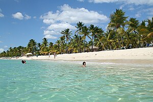
Catalina Island or Isla Catalina is a tropical island located 1.5 miles from the mainland on the south-east corner of the Dominican Republic, near La Altagracia and La Romana. It is an occasional destination for cruise ships on Caribbean routes. In particular, Costa Cruises has a private beach on the island. Their ships anchor offshore and transport passengers to shore via tender.[1]
 Catalina Island, Dominican Republic beach | |
 Catalina Catalina Island, Dominican Republic | |
| Geography | |
|---|---|
| Coordinates | 18°21′36″N 69°00′17″W |
| Area | 9.6 km2 (3.7 sq mi) |
| Length | 4.5 km (2.8 mi) |
| Width | 3.0 km (1.86 mi) |
| Highest elevation | 60 ft (18 m) |
| Administration | |
| Province | La Romana |
Geography
The island itself is only 9.6 square kilometers in size, and is a diverse preservation of eco-systems including sand dunes, mangroves, and reefs. Formed out of coral stone, the island contains three overlapping plateaus. The highest elevation on the island is only 60 feet above sea level. The seas around the Island are rich in wildlife, with many species of birds and tropical marine fish, and there are large areas where natural sandbars offshore bring the depth to just a few feet.
History

The island was baptized "Santa Catalina" by Christopher Columbus, who visited it in May 1494.
William Kidd's Quedagh Merchant
On December 13, 2007, the shipwreck of a 17th-century merchant vessel was found at a depth of three meters roughly 70 meters off of the island. It has since been identified as the pirate Captain William Kidd's 1699 Quedagh Merchant, also known as the Cara Merchant, according to Kidd's original testimony during his trial prior to his hanging on May 23, 1701. A team of researchers from Indiana University led by Charles Beeker, Director of the Office of Underwater Science at Indiana University, first discovered the wreckage in 2007 and have since established a Marine Protected Area in an attempt to preserve both the archaeological remains of the shipwreck and its surrounding reef ecosystem. The famed shipwreck has been nominated as a Living Museum in the Sea. Living Museums in the Sea is a program started by Charles Beeker with the goal of protecting submerged cultural and biological resources around the world.
In a partnership with the Children's Museum of Indianapolis and the Oficina Nacional de Patrimonio Cultural Subacuático (ONPCS), Indiana University recovered one of the 26 cannons found on the wreckage of the Quedagh Merchant. The cannon is now on display at the "National Geographic: Treasures of the Earth" exhibit in Indianapolis. At the Children's Museum of Indianapolis, Indiana University students teach visitors about the Quedagh Merchant as well as the history of the country, maritime history, artifact conservation, and archaeology.
Tourism
The island is a popular destination, and ships travel daily to Catalina from La Romana to visit the beach, snorkel, and view the corals close to the shore.
Scuba diving

Catalina Island is a popular destination for scuba diving thanks to its coral reef and marine ecosystems. Dive sites include the Wall and the Aquarium; tropical fish that can be seen there include the sergeant major, damselfish, squirrelfish, and stingrays. There are weekly trips to Catalina Archived 2019-12-10 at the Wayback Machine from Punta Cana.
See also
- Isla Saona
References
- "Falling in Love With Catalina Island". Caribbean Journal. 2016-07-11. Retrieved 2020-10-22.
На других языках
[de] Isla Catalina
Die etwa 9 km² große Insel Isla Catalina, von der indigenen Bevölkerung auch Toeya genannt, liegt im Osten der Dominikanischen Republik ca. 3 km südwestlich des Festlands zwei Kilometer südlich der Küstenstadt La Romana. Sie weist einen annähernd dreieckigen Grundriss auf. Sie ist jedoch Teil der weiter östlich gelegenen Provinz La Altagracia und gehört dort zum Bezirk Bayahibe der Gemeinde San Rafael del Yuma.- [en] Catalina Island (Dominican Republic)
[es] Isla Catalina (República Dominicana)
Isla Catalina, también denominada Isla Ikiita (llamada también por los indígenas locales como Toeya), es una isla que se encuentra en el mar Caribe a sólo unos kilómetros al sureste de la Isla La Española al sur de la provincia de La Romana que es parte de la República Dominicana. Desde La Romana se tarda media hora en llegar a Isla Catalina. Posee una superficie aproximada de 9,6 kilómetros cuadrados y está deshabitada. La isla integra el trío de islas adyacentes del sureste del país junto a la Saona y la Catalinita.[1] Posee diversas bellezas naturales, como sus playas paradisíacas con arenas blancas y en las aguas cristalinas que la rodean viven distintas especies de aves y peces. La isla fue bautizada así por el navegante Cristóbal Colón en su viaje por el área en mayo de 1494.Es un popular destino turístico y lugar que frecuentan algunos cruceros del Caribe.[fr] Île Catalina
L'île Catalina (Isla Catalina) est une île tropicale de la mer des Caraïbes, située au sud-est de la République dominicaine dans la province de La Romana.[it] Isola Catalina
L'isola Catalina (Isla Catalina) è un'isola tropicale del mare dei Caraïbi, situata a circa 2 Km dalla costa sud-orientale, della Repubblica Dominicana, di cui fa parte, appartenendo alla provincia La Romana.[ru] Каталина (остров)
Каталина (исп. Isla Catalina) — остров в Карибском море. Принадлежит Доминиканской Республике.Другой контент может иметь иную лицензию. Перед использованием материалов сайта WikiSort.org внимательно изучите правила лицензирования конкретных элементов наполнения сайта.
WikiSort.org - проект по пересортировке и дополнению контента Википедии