geo.wikisort.org - Island
Cal Islet (Portuguese: Ilhéu da Cal, also: Ilhéu de Baixo) is a small island about 500 m (1,600 ft) south of Porto Santo Island, in the Madeira Archipelago, Portugal. With an area of 1.40 km2 (0.54 sq mi),[1] Cal is the largest of six islets close to Porto Santo. The highest point is 178 m (584 ft).[2] The islet has never been inhabited.
 Cal Islet, viewed from Porto Santo | |
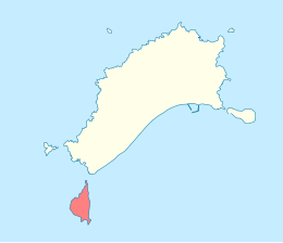 Location within the Municipality of Porto Santo | |
| Geography | |
|---|---|
| Location | Atlantic Ocean |
| Coordinates | 33.0089°N 16.3869°W |
| Total islands | 1 |
| Area | 1.40 km2 (0.54 sq mi) |
| Highest elevation | 178 m (584 ft) |
| Concelhos (Municipalities) | Porto Santo |
| Demographics | |
| Population | 0 |
History
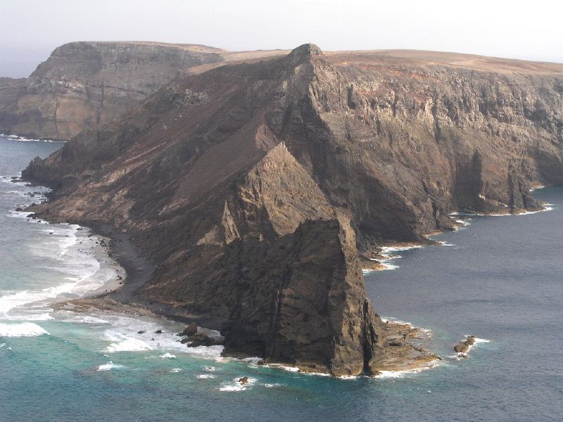
Cal Islet houses an important testimony to the history and culture of Porto Santo. It was once mined for lime (cal in Portuguese). Its extraction led to several accidents, one of which killed sixteen workers, victims of a mine collapse. The mines are no longer active, but remnants are still intact and can be visited with a proper license and specialized escort.
The construction of a cable car was planned to connect the tip of Calheta (in Porto Santo) to the islet. The project was abandoned because the large numbers of visitors would have endangered the regeneration of the islet's fragile ecosystem.[3]
Ecological Preservation

Despite of its rough appearance, this islet is home to a very rich flora, which includes the usual coastal shrubs and some traces of laurisilva, probably due to its difficult access. It is also a breeding ground for at least four species of birds, the Atlantic canary, the Berthelot's pipit, the plain swift and the little shearwater[4] and home to endemic land snails, Amphorella cimensis[5] and Leiostyla relevata.[6] For these reasons, its ecosystem is protected by the Portuguese PDM and Rede Natura 2000.[3]
In these areas with very high ecological value and great vulnerability to human pressure or reduced capacity for regeneration, only activities of a scientific nature are allowed and, exceptionally, in previously selected areas, places of observation in the scope of leisure and recreational uses.
— Municipal Master Plan of Porto Santo, article no.54.
References
- m@pas online, Direção-Geral do Território
- Porto Santo – História
- "Ilhéu de Baixo ou da Cal em Porto Santo". visit-portosanto. Retrieved October 10, 2020.
- "Ilhéus do Porto Santo" (PDF). SPEA. Archived from the original (PDF) on 2007-06-10. Retrieved October 10, 2020.
- D. Teixeira; et al. (2016). "Amphorella cimensis". IUCN Red List of Threatened Species. 2016. Retrieved 2018-10-05.
- M.B. Seddon (2010). "Leiostyla relevata". IUCN Red List of Threatened Species. 2010. Retrieved 2018-10-05.
External links
This Madeira location article is a stub. You can help Wikipedia by expanding it. |
На других языках
[de] Ilhéu da Cal
Ilhéu da Cal, oft auch als Ilhéu de Baixo bezeichnet, ist eine kleine, unbewohnte Insel in der portugiesischen autonomen Region Madeira.- [en] Cal Islet
[fr] Îlot de Cal
L'îlot de Cal ou îlot de Baixo (en portugais Ilhéu da Cal) est l'un des six îlots situés à moins de 400 mètres de la rive de l'île de Porto Santo, faisant partie de l'archipel de Madère, région autonome du Portugal. Il se situe à l'extrême sud de Porto Santo et il est inhabité.[ru] Кал (остров)
Кал или Нижний остров (порт. Ilhéu da Cal или порт. Ilhéu de Baixo) — скалистый необитаемый островок, часть архипелага Мадейра, Португалия. Находится в 400 м от острова Порту-Санту. Через остров проходит 33-я параллель.Другой контент может иметь иную лицензию. Перед использованием материалов сайта WikiSort.org внимательно изучите правила лицензирования конкретных элементов наполнения сайта.
WikiSort.org - проект по пересортировке и дополнению контента Википедии