geo.wikisort.org - Island
Beata Island (Spanish: Isla Beata) is a small island on the Caribbean Sea, located 7 km (4 mi) southwest from Cape Beata. Some 12 km (7 mi) southwest of it lies the smaller Alto Velo Island. It is politically part of the Dominican Republic, and is roughly triangle-shaped and fairly flat, with an approximate area of 27 km2 (10 sq mi).
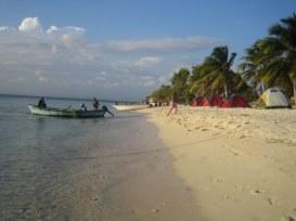 Beata's shore | |
 Beata Beata Island (Dominican Republic) | |
| Geography | |
|---|---|
| Coordinates | 17°34′42″N 71°30′42″W |
| Area | 27 km2 (10 sq mi) |
| Administration | |
| Province | Pedernales Province |
| Demographics | |
| Population | 10 (2010) |
| Pop. density | 0/km2 (0/sq mi) |
History
Beata Island was discovered by Europeans during the second voyage of Christopher Columbus in 1494. Originally populated by Taíno natives, the island became a colonial asset of the Captaincy General of Santo Domingo and the greater Spanish Empire. The island was the site of various military engagements between the Spanish and roving pirates.[citation needed]
Geography

The landscape is somewhat varied, with mangrove swamps on parts of the North shore, sandy coves and beaches on the west coast. Most of the interior of the island is covered by various subtypes of xeric semi-deciduous limestone forests.
Geologically, the island is basically made out of limestone, the erosion of which causes very jagged surfaces on exposed rocks (called diente de perro or dogtooth), and several sinkholes and cenotes. It has a large population of rhinoceros iguanas. Beata Island is currently unhabitated, save for short stays by fishermen from the mainland and a permanent Dominican military base with rotating personnel .
See also
- Geography of the Dominican Republic
References
На других языках
[de] Isla Beata
Isla Beata ist eine unbewohnte Insel im Karibischen Meer, südlich der zu den Großen Antillen zählenden Insel Hispaniola gelegen. Sie ist mit 27 km² Fläche nach Isla Saona die zweitgrößte Insel der Dominikanischen Republik und gehört zur Gemeinde Pedernales der gleichnamigen Provinz. Die dreieckig geformte und nahezu flache Insel liegt etwa sechs Kilometer südwestlich von Cabo Beata, dem südlichsten Punkt von Hispaniola, und ist davon durch den Canal de la Beata getrennt. Sie stellt jedoch noch nicht das südlichste Territorium der Dominikanischen Republik dar, da 11,6 Kilometer weiter im Südwesten noch das kleine Eiland Alto Velo liegt, jenseits des Canal de Alto Velo.- [en] Beata Island
[es] Isla Beata
Isla Beata es una isla en el mar Caribe, ubicada 7 km al suroeste de Cabo Beata, el punto más meridional de la isla La Española. Pertenece a la República Dominicana. Isla Beata tiene forma de triángulo y es plana. La isla abarca 27 km² de superficie y está deshabitada. Existe un caracol gigante llamado lambí (Strombus gigas) y también tortugas marinas, cangrejos y langostas. Estas especies están desapareciendo de la isla debido a la caza. Ahora, aquí vive una pequeña colonia de cabras salvajes. En 2001 fue descubierta en esta isla una especie que es endémica de la reserva natural parque nacional Jaragua (en la cual está ubicada), es un geco (Sphaerodactylus ariasae) que es considerado como uno de los dos reptiles más pequeños del mundo (16 mm).[fr] Île Beata
L'île Beata (Isla Beata) est une île dominicaine de la mer des Caraïbes. Elle est située à six kilomètres au sud-ouest du cap Beata, le point le plus méridional d'Hispaniola. Elle est incluse dans le parc national Jaragua dans la province de Pedernales.[ru] Беата (остров)
О́стров Беа́та (исп. Isla Beata) — небольшой остров в Карибском море, расположенный в 7 км к юго-западу от мыса Беата, который является самой южной точкой острова Эспаньола (Гаити).Другой контент может иметь иную лицензию. Перед использованием материалов сайта WikiSort.org внимательно изучите правила лицензирования конкретных элементов наполнения сайта.
WikiSort.org - проект по пересортировке и дополнению контента Википедии