geo.wikisort.org - Island
The Batu Islands are an archipelago of Indonesia located in the Indian Ocean, off the west coast of Sumatra, between Nias and Siberut. The three primary islands, of approximately equal size, are Pini, Tanahmasa, and Tanahbala. There are seventy-five smaller islands, of which the largest are Sipika, Tello and Sigata (all off the west coast of Tanahmasa), Simuk (considerably further to the west) and Bojo (to the south of Tanahbala); less than half are inhabited. The total land area of the seven administrative districts is 1,201.1 km2. The islands are governed as a part of South Nias regency within North Sumatra province. In Indonesian and Malay, batu means rock or stone.
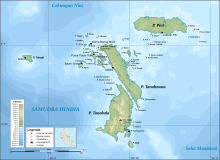


The equator passes through the archipelago, north of Tanahmasa and south of Pini. Administratively, Pini (with offshore islets) forms the Pulau Pulau Batu Timur (East Batu Islands) District of South Nias Regency. The rest of the archipelago at the 2010 Census formerly comprised the Pulau Pulau Batu (Batu Islands) and Hibala Districts of the same regency; however, both have been subsequently divided to form new Districts - Tanahmasa District has been formed from part of Hibala District, and three new districts have been formed from parts of Pulau Pulau Batu District - namely Pulau Pulau Batu Barat (West Batu Islands), Pulau Pulau Batu Utara (North Batu Islands, which lie to the north of Tanamasa) and Simuk Districts. The original districts remain with reduced areas and population, and thus the islands now form seven separate districts.
| Name | Area in km2 | Population Census 2010[1] | Population Census 2020[2] | Administrative centre (with location) | Number of villages | Post code |
|---|---|---|---|---|---|---|
| Hibala (a) | 225.75 | 9,620 | 7,716 | Eho (on Tanabala Island) | 17 | 22881 |
| Tanahmasa | 451.43 | (b) | 4,807 | Baluta (on Tanamasa Island) | 12 | 22887 |
| Pulau Pulau Batu (c) (Batu Islands) | 105.09 | 16,365 | 9,731 | Pasar Pulau Tello (on Tello Island) | 22 | 22882 |
| Pulau Pulau Batu Timur (East Batu Islands) | 372.05 | 2,483 | 3,091 | Labuhan Hiu (on Pini Island) | 10 | 22884 |
| Simuk (island) | 20.42 | (d) | 1,934 | Gobo (on Simuk Island) | 6 | 22886 |
| Pulau Pulau Batu Barat (e) (West Batu Islands) | 21.06 | (d) | 2,320 | Bawositora (on Sigata Island) | 9 | 22883 |
| Pulau Pulau Batu Utara (f) (North Batu Islands) | 6.30 | (d) | 3,894 | Silima Banua Marit (on Marit Island) | 12 | 22885 |
| Totals for Kepulauan Batu | 1,201.10 | 28,468 | 33,493 | 88 | ||
Notes: (a) Hibala District now comprises 42 islands, chiefly Tanahbala Island but including Bojo Island to its south.
(b) The 2010 population of Tanah Masa District (comprising that part of Tanahmasa Island previously part of Hibala District) is included in the 2010 population of Hibala District.
(c) Pulau Pulau Batu District now includes various small islands, including Tello, Batumakele and Sibele.
(d) The 2010 populations of Simuk District (Simuk Island), Pulau Pulau Batu Barat District and Pulau Pulau Batu Utara District are included in the 2010 population of Pulau Pulau Batu District.
(e) comprises numerous small islands including Sigata, Sipika, Pono, Sibaranu, Hayo and Bintuang.
(f) comprises numerous small islands including Marit, Lorang, Memong and Lorang.
The four new districts in the Batu Islands are Pulau Pulau Batu Barat (West Batu Islands), Pulau Pulau Batu Utara (North Batu Islands), Simuk (Simuk Island) and Tanah Masa (that part of Tanahmasa Island previously part of Hibala District).
People
The people of the Batu Islands have had substantial interaction with the populations of Nias, to the north, whose language they share. The islands have occasionally been a destination for slaves who escaped from Nias, and in the past decade have become a destination for surfing boat charters from Padang, on the Sumatran mainland. The population at the 2010 Census was 28,468.[3]
The islands were visited by Simon Reeve during Equator, a 2006 BBC TV Series.
Wildlife
A population of the Sunda clouded leopard had been recorded here.[4]
See also
References
- Biro Pusat Statistik, Jakarta, 2011.
- Badan Pusat Statistik, Jakarta, 2021.
- Biro Pusat Statistik, Jakarta, 2011.
- Wilting A.; Christiansen P.; Kitchener A. C.; Kemp Y. J. M.; Ambu L.; Fickel, J. (2010). "Geographical variation in and evolutionary history of the Sunda clouded leopard (Neofelis diardi) (Mammalia: Carnivora: Felidae) with the description of a new subspecies from Borneo". Molecular Phylogenetics and Evolution. 58 (2): 317–28. doi:10.1016/j.ympev.2010.11.007. PMID 21074625.[permanent dead link]
| Authority control |
|
|---|
На других языках
[de] Batu-Inseln
Die Batu-Inseln (indonesisch Kepulauan Batu, wörtlich „Inselgruppe Fels“) sind eine Inselgruppe vor der Westküste Sumatras im Malaiischen Archipel und gehören zum Regierungsbezirk Nias Selatan in der indonesischen Provinz Nordsumatra.- [en] Batu Islands
[fr] Îles Batu
Les îles Batu (en indonésien : "pierre, rocher") sont un archipel d'Indonésie situé dans l'océan Indien au large de la côte occidentale de Sumatra, entre les îles de Nias et Siberut. L'archipel couvre une superficie totale de 16 500 km². Les trois principales îles en sont Pini, Tanah Masa et Tanah Bala. Il y a encore 48 îles plus petites, dont moins de la moitié est habitée.[it] Isole Batu
Le Isole Batu (indonesiano: Kepulauan Batu) è un gruppo di isole indonesiane.[ru] Бату (острова)
Бату (индон. Kepulauan Batu) — небольшой архипелаг в Индийском океане.Другой контент может иметь иную лицензию. Перед использованием материалов сайта WikiSort.org внимательно изучите правила лицензирования конкретных элементов наполнения сайта.
WikiSort.org - проект по пересортировке и дополнению контента Википедии