geo.wikisort.org - Island
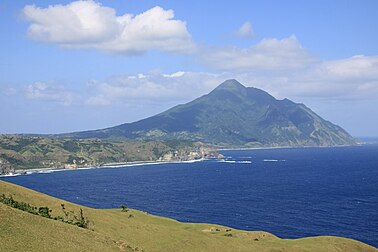
Batan Island (/bɑːˈtɑːn/ bah-TAHN[4]) is the main island of Batanes, an archipelagic province in the Philippines. It is the second largest of the Batanes Islands, the northernmost group of islands in the country. Four of the six municipalities of Batanes are located on the 20-kilometer (12 mi) long island including the provincial capital of Basco. The other municipalities are Ivana, Mahatao and Uyugan.
 | |
 Batan Island Location within Batanes  Batan Island Batan Island (Luzon)  Batan Island Batan Island (Philippines) | |
| Geography | |
|---|---|
| Location | Luzon Strait |
| Coordinates | 20°25′17″N 121°57′37″E |
| Archipelago | Batanes Islands |
| Adjacent to |
|
| Area | 95.18 km2 (36.75 sq mi)[1] |
| Length | 20 km (12 mi)[2] |
| Width | 6.5 km (4.04 mi) at its widest |
| Highest elevation | 1,009 m (3310 ft)[2] |
| Highest point | Mount Iraya |
| Administration | |
Philippines | |
| Region | Cagayan Valley |
| Province | Batanes |
| Municipalities | |
| Demographics | |
| Population | 14,007 (2020 est.) [3] |
| Pop. density | 134/km2 (347/sq mi) |
| Ethnic groups | Ivatans |
| Additional information | |
 | |
Geography
Batan is a dumbbell-shaped volcanic island, part of the Luzon Volcanic Arc. The northern part of the island is dominated by the 1,009-meter (3,310 ft) high active volcano, Mount Iraya, which last erupted in 1454.[2] The lower portion of the island is the inactive volcano Mount Matarem, about 405 meters (1,329 ft) tall.[5][6] A hilly narrow neck of land, about 4.5 kilometers (2.8 mi) long and from 1.9 to 2.5 kilometers (1.2 to 1.6 mi) wide, separates the two volcanoes of the island. Near Mt. Matarem, the island is at its widest at about 6.5 kilometers (4.0 mi).
Sabtang Island, the nearest island to Batan is located about 4.5 kilometers (2.8 mi) southwest of the southern tip of the island. Itbayat, the largest island of the archipelago, is about 32 kilometers (20 mi) northwest of the central part of Batan.
Events
The Japanese invasion of the Philippines began with the invasion of Batan Island by a 490-man naval combat unit and an indeterminate number of air corps troops, on two transports escorted by one destroyer and four torpedo boats. This was the first landing on American territory, the same day as the attack on Pearl Harbor. Japanese forces quickly secured the existing small airfield outside Basco without resistance and began expansion work immediately as a forward base for operations against Luzon. However, work was discontinued only a few days later as the success of the Japanese bombing of Clark Field rendered a base at Basco redundant. On 10 December 1941, the naval combat force was withdrawn.[7]
See also
References
- "Philippine Standard Geographic Code (PSGC) - Province: BATANES". nap.psa.gov.ph. Philippine Statistics Authority. Archived from the original on 18 April 2018. Retrieved 17 April 2018.
- "Iraya". Global Volcanism Program. Retrieved on 2013-04-11.
- Census of Population (2015). "Region II (Cagayan Valley)". Total Population by Province, City, Municipality and Barangay. PSA. Retrieved 20 June 2016.
- Merriam-Webster's Geographical Dictionary, 3rd ed. (ISBN 0-87779-546-0; Springfield, MA: Merriam-Webster Inc., 1997), p. 119.
- "Inactive Volcanoes Part 5". Philippine Institute of Volcanology and Seismology. Retrieved on 2013-04-11.
- "Mount Mataram". Google Maps. Retrieved on 2013-04-11.
- "The First Landings". Retrieved 18 March 2014.
External links


 Media related to Batan Island at Wikimedia Commons
На других языках
[de] Batan (Batanes)
Die Insel Batan (früher Divatan) gehört zu der gleichnamigen Inselgruppe der Batan-Inseln. Sie liegt im Norden der Philippinen in der Provinz Batanes. Das Aussehen der Insel wird besonders von den zwei Bergen Iraya und Mahtarem bestimmt. Die Küstenlinie wird vor allem von der großen Bucht Mananioy im Osten gekennzeichnet. Batan weist eine Fläche von 76 km² auf.[1] Im Jahre 2000 lebten 11.173 Menschen auf der Insel.[2] Eine andere Insel Batan liegt in der philippinischen Provinz Albay.- [en] Batan Island
[es] Isla de Batán
Batán o Batang es la segunda más grande de las islas de la provincia de Batanes en Filipinas, posee 35 km² y unos 11.000 habitantes. Su capital es Basco, que a su vez lo es de la provincia. Los otros municipios son Ivana, Mahatao y Uyugan.[fr] Île de Batan
L'île de Batan est la principale île de l'archipel des Batanes, une province archipélagique des Philippines située en mer de Chine méridionale. Elle est la deuxième îles de l'archipel en superficie. Quatre des six municipalités des Batanes sont situés sur cette île de 20 kilomètres de long dont Basco, la capitale provinciale Basco. Les trois autres municipalités sont Ivana, Mahatao et Uyugan.[ru] Батан (остров)
Бата́н[1] (англ. Batan Island) — вулканический остров, расположенный в Лусонском проливе на границе Филиппинского и Южно-Китайского морей. Административно относится к провинции Батанес[2] (регион Долина Кагаян, Филиппины). 43-й по площади остров страны.Другой контент может иметь иную лицензию. Перед использованием материалов сайта WikiSort.org внимательно изучите правила лицензирования конкретных элементов наполнения сайта.
WikiSort.org - проект по пересортировке и дополнению контента Википедии