geo.wikisort.org - Island
The Barren Islands (Sugpiaq: Usu'unaat) are an archipelago in Alaska in the United States. They are the northernmost islands of the Kodiak Archipelago. The largest island of the group is Ushagat Island. The islands have a combined land area of 16.23 square miles (42.03 km²) and are uninhabited. The largest breeding grounds of seabirds in Alaska are located in the Barren Islands on East Amatuli Island and Nord Island. The archipelago is part of the Alaska Maritime National Wildlife Refuge.
Native name: Usu'unaat | |
|---|---|
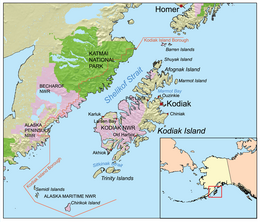 The Barren Islands are the northernmost islands in the Kodiak Archipelago, and are located northeast of Shuyak Island and southwest of the Kenai Peninsula. | |
| Geography | |
| Location | Gulf of Alaska |
| Coordinates | 58°55′N 152°16′W |
| Archipelago | Kodiak Archipelago |
| Total islands | 6 |
| Area | 42.03 km2 (16.23 sq mi) |
| Administration | |
United States | |
| State | Alaska |
| Borough | Kodiak Island |
| Demographics | |
| Population | 0 (2010) |
| Additional information | |
| Part of Alaska Maritime National Wildlife Refuge | |
Geography
The Barren Islands are a group of islands in the Gulf of Alaska that lie off the south-central coast of Alaska in the United States. They are the northernmost islands of the Kodiak Archipelago. They are located between the Kenai Peninsula on the Alaskan mainland to their northeast and Shuyak Island in the Kodiak Archipelago to their southwest. They stretch across 15 miles (24 km) of the Gulf of Alaska, centered around 57°48′N 152°15′W.
The Barren Islands group is made up of six islands:
- East Amatuli Island, the easternmost island, 2.5 miles (4.0 km) long, located 70 miles (110 km) northeast of Afognak, Alaska, at 58°55′N 152°00′W.[1]
- West Amatuli Island, also known as Amatuli Island, 3 miles (4.8 km) long, located between East Amatuli and Ushagat Islands, 70 miles (110 km) northeast of Afognak, at 58°56′N 152°03′W.[2]
- Ushagat Island, the westernmost and largest island, 8 miles (12.9 km) long, located 68 miles (109 km) northeast of Afognak at 58°55′30″N 152°15′00″W.[3]
- Nord Island, 0.5 miles (0.8 km) across, located 1.5 miles (2.4 km) northeast of Ushagat Island and 72 miles (116 km) northeast of Afognak at 58°58′15″N 152°09′00″W.[4]
- Sud Island, 1 mile (1.6 km) long, located 5 miles (8.0 km) northwest of Nord Island at 58.8975°N 152.2094°W.[5]
- Sugarloaf Island, 0.7 miles (1.1 km) across, located 1.3 miles (2.1 km) south of East and West Amatuli Islands and 68 miles (109 km) northeast of Afognak, Alaska, at 58°53′10″N 152°02′15″W.[6]
Prominent landmarks on the islands include:
- Amatuli Cove, a 0.6-mile (1.0 km) wide cove on the northwest coast of East Amatuli Island at 58°55′10″N 152°00′15″W[7]
- Table Mountain (1,350 feet; 838 meters) on the northeast end of Ushagat Island at 58°56′35″N 152°10′05″W[8]
Government
The Barren Islands are uninhabited. Administratively, they are part of Alaska′s Kodiak Island Borough. They also make up a part of the Gulf of Alaska Unit of the Alaska Maritime National Wildlife Refuge.
History
The Barren Islands were named on 25 May 1778 by the British explorer Captain James Cook of the Royal Navy, who wrote, "They obtained their name of Barren Isles from their very naked appearance."[9]
References
Footnotes
- Orth, p. 294.
- Orth, p. 1034.
- Orth, p. 1014.
- Orth, p. 695.
- Orth, p. 924.
- Orth, p. 925.
- Orth, p. 70.
- Orth, p. 939.
- Orth, p. 107.
Bibliography
- Orth, Donald J. Dictionary of Alaska Place Names. Washington, D.C.: United States Government Printing Office, 1967.
- Barren Islands: Block 2000, Census Tract 1, Kodiak Island Borough, Alaska (United States Census Bureau)
External links
- Barren Islands in the Geographic Names Information System of the United States Geological Survey
| Authority control |
|---|
На других языках
[de] Barren Islands
Die Barren Islands sind eine Inselgruppe in Alaska, Vereinigte Staaten von Amerika. Sie sind die nördlichsten Inseln des Kodiak-Archipels. Die größte Insel der Gruppe ist Ushagat Island. Die Inselgruppe hat eine Ausdehnung von 42,03 km² und ist unbewohnt.[1] Auf den Inseln East Amatuli Island und Nord Island befinden sich mit die größten Brutgebiete von Seevögeln in Alaska. Die Inselgruppe gehört zum Alaska Maritime National Wildlife Refuge.- [en] Barren Islands
[it] Isole Barren
Le isole Barren (isole aride) sono un gruppo di isole in Alaska, Stati Uniti d'America. Si trovano a nord dell'arcipelago Kodiak, tra l'isola Shuyak e l'estrema punta della penisola di Kenai. L'isola maggiore si chiama Ushagat. Le isole hanno in totale una superficie di 42,03 km² e sono disabitate.Другой контент может иметь иную лицензию. Перед использованием материалов сайта WikiSort.org внимательно изучите правила лицензирования конкретных элементов наполнения сайта.
WikiSort.org - проект по пересортировке и дополнению контента Википедии