geo.wikisort.org - Island
Awaji Island (淡路島, Awaji-shima) is an island in Hyōgo Prefecture, Japan, in the eastern part of the Seto Inland Sea between the islands of Honshū and Shikoku. The island has an area of 592.17 square kilometres (228.64 square miles).[1] It is the largest island of the Seto Inland Sea.
Native name: 淡路島 Awaji-shima | |
|---|---|
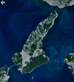 Satellite view of Awaji Island | |
 Awaji Location in Japan  Awaji Awaji (Hyogo Prefecture) | |
| Geography | |
| Location | Seto Inland Sea |
| Coordinates | 34°23′N 134°50′E |
| Area | 592.17 km2 (228.64 sq mi) |
| Length | 53 km (32.9 mi) |
| Width | 28 km (17.4 mi) |
| Highest elevation | 606 m (1988 ft) |
| Administration | |
Japan | |
| Prefecture | Hyōgo Prefecture |
| Demographics | |
| Population | 129,000 (2019) |
| Pop. density | 265/km2 (686/sq mi) |
| Ethnic groups | Japanese |
As a transit between those two islands, Awaji originally means "the road to Awa",[2] the historic province bordering the Shikoku side of the Naruto Strait, now part of Tokushima Prefecture.
Geography
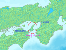
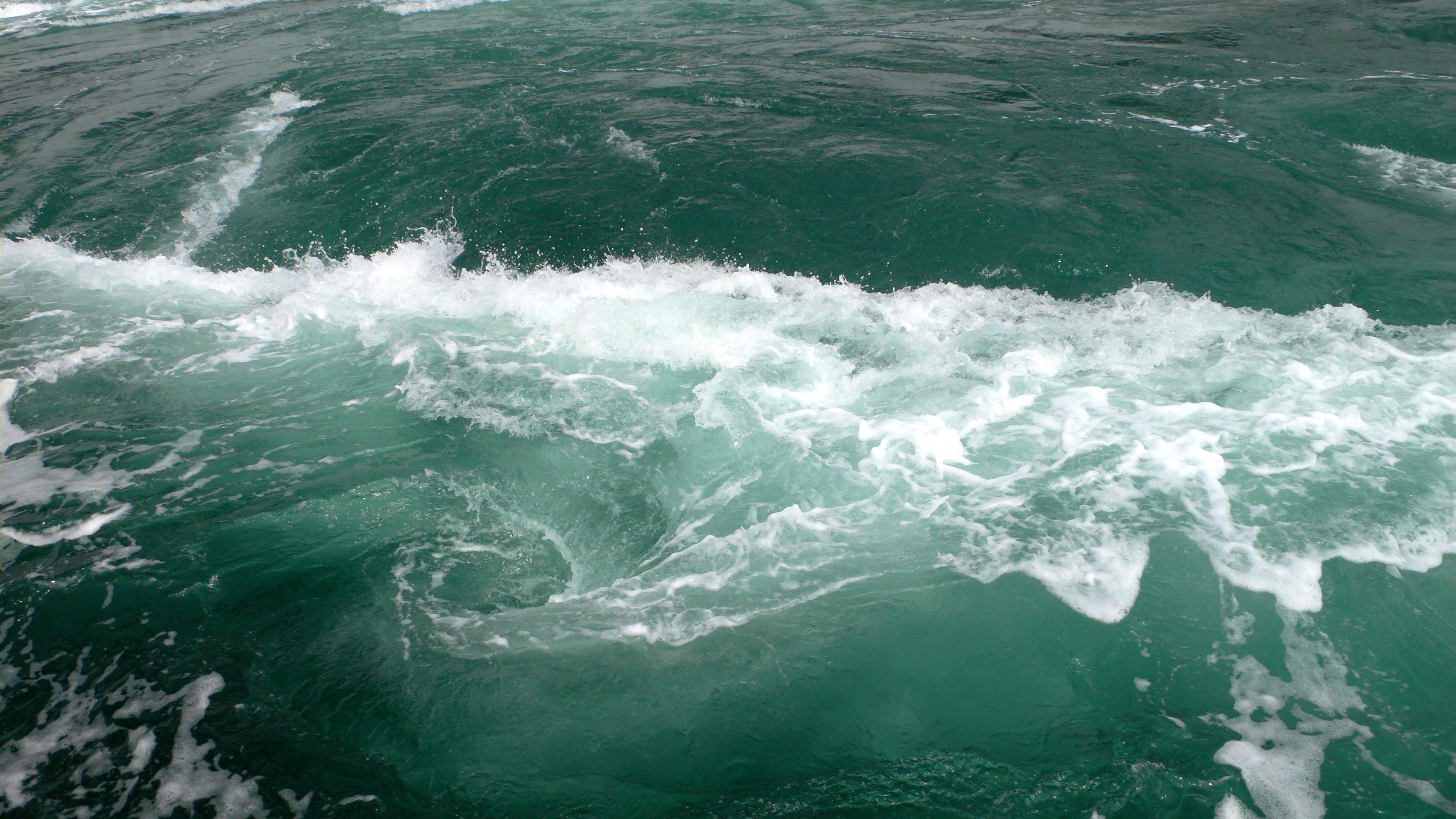
The island is separated from Honshū by the Akashi Strait and from Shikoku by the Naruto Strait. Since April 5, 1998, it has been connected to Kobe on Honshū by the Akashi Kaikyō Bridge, the longest suspension bridge in the world.[3] Since its completion the Kobe-Awaji-Naruto Expressway across the island has been the main eastern land link between Honshū and Shikoku. The Naruto whirlpools form in the strait between Naruto, Tokushima and Awaji.[4]
The Nojima Fault, responsible for the 1995 Great Hanshin earthquake, cuts across the island. A section of the fault was protected and turned into the Nojima Fault Preservation Museum in the Hokudancho Earthquake Memorial Park (北淡町震災記念公園) to show how the movement in the ground cut across roads, hedges and other installations. Outside of this protected area, the fault zone is less visible.[5] The Onaruto Bridge Memorial Museum (大鳴門橋記念館, Ōnarutokyō Kinenkan) and the Uzushio Science Museum (うずしお科学館, Uzushio Kagakukan) are located near Fukura.[6]
History
According to the creation myth in Shinto, Awaji was the first of the ōyashima islands born from the kami Izanagi and Izanami.[7] Awaji constituted a province between the 7th and the 19th century, Awaji Province, and was a part of Nankaidō. Today the island consists of three municipalities: Awaji, Sumoto and Minamiawaji.
The Awaji Ningyō-Jōruri, a more-than-500-year-old form of traditional puppet theater, or ningyō-jōruri, daily performs several shows in the Awaji Ningyō-Jōruri Hall (人形浄瑠璃館) in Minamiawaji, Hyōgo in the southern part of the island and is designated an Intangible Cultural Heritage of Japan. The Awaji puppets perform popular traditional dramas but have their origins in religious rituals.[8]
Starting in the 1830s, the local potter Minpei started producing what would be then known as Awaji ware, also known as Minpei ware.
Tadao Ando designed several structures on the island, among them, the Hompuku-ji water temple (本福寺)[9][10] and the Awaji Yumebutai,[11][12] both located in Awaji, Hyōgo.
In 1995, this island was the epicenter of the Kobe earthquake, which killed over 5,502 people.[citation needed]
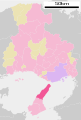
Municipalities
There are 3 municipalities in Awaji island: Awaji, Sumoto and Minamiawaji. They are part of Hyogo Prefecture.
 Awaji municipality on Awaji Island
 Sumoto municipality on Awaji Island
 Minamiawaji municipality on Awaji Island


Gallery
 Sumoto Castle
 Naruto whirlpools
 Awaji Yumebutai flower beds
 Akashi-Kaikyō National Government Park
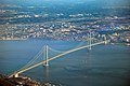 Akashi Kaikyō Bridge


See also
- Thirteen Buddhas of Awaji Island
References
- 本州の島面積 Archived 2008-12-29 at the Wayback Machine (Honshū no Shima Menseki) (Retrieved on July 4, 2009)
- Martin Bermudez. "Geophysical and Seismic Analysis: Of Two Architectural Wonders". Geolabs-Hawaii Hillside Design Laboratory at the University of Hawaii School of Architecture. Archived from the original on 2008-05-28. Retrieved 2008-03-23.
- James D. Cooper (July–August 1998). "World's Longest Suspension Bridge Opens in Japan". U.S. Department of Transportation. Archived from the original on 6 April 2008. Retrieved 2008-03-22.
- Keene, Donald. "Afloat on Japan's Inland Sea," New York Times Magazine. October 6, 1985.
- Chiu Yu-tzu (28 December 2000). "What has Japan done since the Kobe earthquake?". Taipei Times. Retrieved 2009-05-04.
- "Awaji Island and Shodo Island" (PDF). Japan National Tourist Organization. 2001. Retrieved 2008-03-22.
- Genji Shibukawa. "Japanese Creation Myth". Tales from the Kojiki. Harcourt Brace Custom Publishing. Archived from the original on 15 April 2008. Retrieved 2008-03-22.
- Hiroko Yamamoto. "Awaji Ningyo Joruri". Asia-Pacific Database. Archived from the original on 6 April 2008. Retrieved 2008-03-22.
- Flores Zanchi (September 2002). "Tadao Ando, Water Temple, Hompuki, Japan, 1989-1991". Floornature. Archived from the original on 2012-02-09. Retrieved 2008-03-22.
- "Water Temple – ARCHITECTURE OF NOTE – Hompukuji". Via Travel Design. Retrieved 2008-03-22.[permanent dead link]
- Kari Silloway (2004). "Awaji Yumebutai, Hyōgo, Japan". Galinsky. Retrieved 2008-03-22.
- "About Yumebutai". Awaji Yumebutai The Westin Hotel and Resort and International Conference Center. 2006. Archived from the original on 2017-12-24. Retrieved 2008-03-23.
External links
- (in Japanese) Awaji website of Hyōgo prefecture
- (in Japanese) Awaji Island Tourist Association
- (in Japanese) Awaji Island Portal
На других языках
[de] Awaji-shima
Awaji-shima (japanisch 淡路島) ist eine 592,55 km²[1] große Insel zwischen der Harima-See im Westen, der Bucht von Ōsaka im Osten und dem Kii-Kanal im Süden. Sie gehört zur Präfektur Hyōgo und ist die größte Insel der Seto-Inlandsee. Südwestlich in die Harima-See führt die Naruto-Straße und südöstlich in die Bucht von Osaka die Kitan-Straße. Im Norden ist sie über die Akashi-Kaikyō-Brücke mit der japanischen Hauptinsel Honshū, im Süden über die Naruto-Brücke mit der Insel Shikoku verbunden.- [en] Awaji Island
[es] Isla Awaji
La isla de Awaji (淡路島, Awajishima?) es una isla de Japón perteneciente a la prefectura de Hyōgo, localizada en aguas del oriente del mar Interior de Seto, entre las islas de Honshu y Shikoku. Es lugar de tránsito entre estas dos islas, Awaji originalmente significa «el camino a la provincia de Awa». Awaji también se escribe como 淡道.[fr] Awaji-shima
L'île d'Awaji (淡路島, Awajishima?) est une île de 592,1 km2 située dans la préfecture de Hyōgo, au Japon, qui constituait autrefois la province d'Awaji. Elle se trouve dans le nord-est de la mer intérieure de Seto, entre les îles de Honshū et de Shikoku. Sa côte orientale donne sur la baie d'Osaka.[it] Isola Awaji
L'isola Awaji (淡路島 Awaji-shima?) è un'isola della Prefettura di Hyōgo, facente parte dell'arcipelago giapponese. Ha un'area di 592,17 km² e una popolazione di 157.000 abitanti (2005).[ru] Авадзи (остров)
Ава́дзи[1][2] (яп. 淡路島 Авадзи-сима) — остров в Японии. Имеет вытянутую форму с севера на юг, расширяющийся в южной части.Другой контент может иметь иную лицензию. Перед использованием материалов сайта WikiSort.org внимательно изучите правила лицензирования конкретных элементов наполнения сайта.
WikiSort.org - проект по пересортировке и дополнению контента Википедии