geo.wikisort.org - Coast
Anastasia Island is a barrier island located off the northeast Atlantic coast of Florida in the United States. It sits east of St. Augustine, running north–south in a slightly southeastern direction to Matanzas Inlet. The island is about 14 miles (23 km) long[1][2] and an average of 1 mile in width. It is separated from the mainland by the Matanzas River, part of the Intracoastal waterway. Matanzas Bay, the body of water between the island and downtown St. Augustine, opens into St. Augustine Inlet.
 View of Anastasia Island from St. Augustine Lighthouse. | |
 Anastasia Island Anastasia Island  Anastasia Island Anastasia Island (North Atlantic) | |
| Geography | |
|---|---|
| Location | North Atlantic |
| Coordinates | 29.80406°N 81.26692°W |
| Administration | |
| State | Florida |
| County | St. Johns |
Part of the island (the Davis Shores and Lighthouse Park neighborhoods) is within St. Augustine city limits, while other communities on the island include St. Augustine Beach, Coquina Gables, Butler Beach, Crescent Beach, and Treasure Beach.
Fort Matanzas National Monument, a Spanish colonial-era fort built in 1740–1742,[3] is located at the southern end of the island[4] on Rattlesnake Island in the Intracoastal waterway within the park boundaries;[5] it was designed to protect St. Augustine from attack via the Matanzas River.
History
Juan Ponce de León may have landed on the barrier island in 1513.[6] Spanish Admiral Pedro Menéndez de Avilés, founder of St. Augustine, moved his initial settlement to Anastasia Island after a revolt by the Timucuan Indians in 1566.[7] This settlement was short-lived, and the colonists moved back to the mainland[8] at the site of present-day downtown St. Augustine.
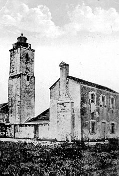
The Spanish built a wooden watch-tower on the northern end of Anastasia Island [9] to warn the town of approaching vessels by raising signal flags.[10] It was sighted by Sir Francis Drake in 1586;[11][12] consequently he came ashore and attacked the city.[13] The Spanish eventually replaced the tower with a coquina structure that was converted into a lighthouse soon after Florida came into the possession of the United States[14] in 1821.[15][16] This was replaced by the present-day St. Augustine Light in 1874.[17] The original lighthouse collapsed in 1880 due to beach erosion and the encroachment of the sea. The earliest built residence on Anastasia Island still standing is the lighthouse keepers' house built in 1876[17] next to the present lighthouse. Several other houses in the Lighthouse Park neighborhood date to the 1880s.
The island was part of a 10,000 acre land grant from the Spanish crown to the land dealer Jesse Fish,[18] who established a plantation, El Vergel (The Orchard), and built his home there in 1763.[19] Fish planted orange groves on the property which produced fruit known as far away as London[20] for its juiciness and sweetness.[21] His production increased annually until 1776, when he shipped a total of 65,000 oranges from Florida.
In 1792, Jesse Fish's son, Jesse Fish, Jr., purchased the tract, amounting to the whole of "St. Anastasia" island except certain lands marked off by officials as reserved, such as the King's Quarry.[22][23] Sarah Fish, Jesse Fish, Jr.'s wife and heir, filed a claim that was reported to Congress in 1826 as valid by the commissioners for East Florida and the Secretary of State of the United States, and subsequently confirmed by an act of Congress on May 23, 1828.[24]
The land developer David Paul Davis, known as "D. P." or "Doc", a native of Green Cove Springs,[25] developed the Davis Shores neighborhood at the north end of Anastasia Island during the land boom of the mid–1920s. In 1925–1926 he filled in the extensive salt marshes located directly opposite the center of St. Augustine across the Matanzas River.[26] As the construction bubble collapsed and real estate values plummeted, D.P. Davis mysteriously disappeared at sea on October 12, 1926.[27] Construction of the Bridge of Lions had begun in 1925 to provide access to his projected development and was completed in 1927.[28] A rehabilitation and partial replacement of the Bridge of Lions, as well as restoration of its two Medici lions statues began in 2006 and was completed in 2010.[29] During World War II the Coast Guard occupied the lighthouse, and other residences in Davis Shores were used as barracks for soldiers.
Beneath the sandy soil of most of the island lie layers of coquina, a shelly rock in various stages of consolidation. This rock is composed primarily of whole and fragmented shells of the donax, or coquina, clam[30] admixed occasionally with scattered fossils of various marine vertebrates, including sharks' and rays' teeth. This deposition is known as the Anastasia Formation,[2] and was formed during the Late Pleistocene epoch, in the period of successive glacial ages from about 110,000 years to 11,700 years ago. It is the only local natural source of stone, and was quarried by the Spanish and later the British to construct many of the buildings in St. Augustine (including the Castillo de San Marcos). An old well and chimney made of coquina rock, located on Old Beach Road,[31] are all that remain of the Spanish barracks built to house the workers who mined the coquina for construction of the fort.[32] These included quarry overseers, masons, and stonecutters.[33] The years-long project (1672-1695) was accomplished with the help of Native American forced labor and African slaves.[34]
Parks
In addition to Fort Matanzas National Monument, Anastasia island is also home to the 1,600-acre (6.5 km2), Anastasia State Park.
See also
- Anastasia State Park
- St. Augustine Light
- St. Augustine Bridge Company
References
- Charles Ledyard Norton (1892). Handbook of Florida. Longmans. p. 175. Retrieved 10 August 2013.
- Orrin H. Pilkey (January 1984). Living with the East Florida Shore. Duke University Press. p. 77. ISBN 978-0-8223-0515-6. Retrieved 11 August 2013.
- Richard R. Henderson; International Council on Monuments and Sites. U.S. Committee; United States. National Park Service (March 1989). A Preliminary inventory of Spanish colonial resources associated with National Park Service units and national historic landmarks, 1987. United States Committee, International Council on Monuments and Sites, for the U.S. Dept. of the Interior, National Park Service. p. 87. ISBN 9780911697032. Retrieved 2 May 2013.
- United States. Office of Archeology and Historic Preservation; Luis R. Arana (1967). Castillo de San Marcos National Monument ... and Fort Matanzas National Monument ...: historical research management plan. p. 24. Retrieved 11 August 2013.
- The Code of Federal Regulations of the United States of America. U.S. Government Printing Office. 1957. p. 187. Retrieved 11 August 2013.
- Edward W. Lawson (1946). The Discovery of Florida and Its Discoverer Juan Ponce de Leʹon: By Edward W. Lawson. Edward W. Lawson. p. 28. Retrieved 11 August 2013.
- David B. Williams (1 July 2009). Stories in Stone: Travels Through Urban Geology. Bloomsbury Publishing. p. 97. ISBN 978-0-8027-1981-2. Retrieved 11 August 2013.
- Sabrina Crewe; Janet Riehecky (1 November 2002). The Settling of St. Augustine. Gareth Stevens. p. 28. ISBN 978-0-8368-3395-9. Retrieved 11 August 2013.
- James W. Raab (2008). Spain, Britain, and the American Revolution in Florida, 1763-1783. McFarland & Company Incorporated Pub. p. 14. ISBN 978-0-7864-3213-4. Retrieved 11 August 2013.
- Reynolds 1890, p. 78
- Charles Bingham Reynolds (1890). The standard guide, St. Augustine. E.H. Reynolds. p. 77. Retrieved 11 August 2013.
- José Agustín Balseiro; Vicente Murga Sanz (1 February 1977). The Hispanic presence in Florida. E. A. Seemann Pub. p. 78. ISBN 978-0-912458-82-3. Retrieved 11 August 2013.
- Karen D. Harvey; Karen G. Harvey (1992). America's First City: St. Augustine's Historic Neighborhoods. Tailored Tours Publications. p. 46. ISBN 978-0-9631241-2-8. Retrieved 11 August 2013.
- Reynolds 1890, p. 79
- Tim Harrison; Ray Jones (1 October 1999). Lost Lighthouses: Stories and Images of America's Vanished Lighthouses. Globe Pequot Press. pp. 99–. ISBN 978-0-7627-0443-9. Retrieved 11 August 2013.
- William R. Adams (2009). St. Augustine and St. Johns County: A Historical Guide. Pineapple Press Inc. p. 80. ISBN 978-1-56164-432-2. Retrieved 11 August 2013.
- "St. Augustine Light". Inventory of Historic Light Stations: Florida Lighthouses. Maritime Heritage Program National Park Service. Retrieved 11 August 2013.
- Robert L. Gold (July 1973). "That Infamous Floridian, Jesse Fish". The Florida Historical Quarterly (1 ed.). Florida Historical Society. 52: 6. Retrieved 11 August 2013.
- Fernando Nuez Viñals (2002). La herencia árabe en la agricultura y el bienestar de occidente. Universitat Politècnica de València, Servicio de Publicacion. p. 441. ISBN 978-84-9705-244-3. Retrieved 11 August 2013.
- Ida Keeling Cresap (1982). The History of Florida Agriculture: The Early Era. p. 31. Retrieved 11 August 2013.
- John McPhee (1 April 2011). The John McPhee Reader. Farrar, Straus and Giroux. p. 35. ISBN 978-0-374-70858-0.
- "HENRY L. MITCHELL, Governor of the State of Florida, William D. Bloxham, Comptroller of the State of Florida, et al., Appts., v. CHARLES M. FURMAN, in His Own Right, and as Administrator of Charles M. Furman, Deceased, et al". Courts.gov. Archived from the original on May 17, 2010. Retrieved 12 August 2013.
- Florida Historical Records Survey (1940). Spanish Land Grants in Florida: Briefed Translations from the Archives of the Board of Commissioners for Ascertaining Claims and Titles to Land in the Territory of Florida... State Library Board. p. 120. Retrieved 13 August 2013.
- United States. Supreme Court (1921). United States Supreme Court Reports. Lawyers Co-operative Publishing Company. p. 609. Retrieved 11 August 2013.
- David Nolan (1995). The Houses of St. Augustine. Pineapple Press Inc. p. 76. ISBN 978-1-56164-075-1. Retrieved 11 August 2013.
- Nick Wynne; Richard Moorhead (2010). Paradise for Sale: Florida's Booms and Busts. The History Press. p. 89. ISBN 978-1-59629-844-6. Retrieved 11 August 2013.
- Beth Rogero Bowen; The St. Augustine Historical Society (March 2012). St. Augustine in the Roaring Twenties. Arcadia Publishing. pp. 7–8. ISBN 978-0-7385-9121-6.
- Rodney Kite-Powell (2013). History of Davis Islands: David P. Davis and the Story of a Landmark Tampa Neighborhood. Arcadia Publishing Incorporated. p. 72. ISBN 978-1-62584-000-4.
- Doug Dillon (23 December 2010). St. Augustine. Mitchell Lane Publishers, Incorporated. p. 43. ISBN 978-1-61228-031-8.
- David B. Williams (1 July 2009). Stories in Stone: Travels Through Urban Geology. Bloomsbury Publishing. pp. 100–103. ISBN 978-0-8027-1981-2. Retrieved 11 August 2013.
- "1801-1809 Old Beach Rd St Augustine, FL 32080". Google Maps. Retrieved 11 August 2013.
- William R. Adams (2009). St. Augustine and St. Johns County: A Historical Guide. Pineapple Press Inc. pp. 81–82. ISBN 978-1-56164-432-2. Retrieved 11 August 2013.
- "Old Spanish Chimney and Well". Florida Historical Markers. Waymarking.com. Retrieved 11 August 2013.
- Daniel S. Murphree (9 March 2012). Native America. ABC-CLIO. p. 199. ISBN 978-0-313-38127-0. Retrieved 15 August 2013.
External links
- St. Augustine Lighthouse and Museum website
- Lighthouse Archaeological Maritime Program (LAMP) website Maritime archaeology around Anastasia Island
- Anastasia State Park at Florida State Parks
Authority control | |
|---|---|
| General |
|
| National libraries | |
| Other | |
На других языках
- [en] Anastasia Island
[fr] Anastasia Island
Anastasia Island est une île qui se trouve sur la côte nord-est de la Floride aux États-Unis. Elle se situe à l'est et au sud-est de la ville de Saint Augustine. Elle est séparée du continent par la Matanzas River. Une partie de l'île appartient à la commune de Saint Augustine. Elle possède un phare construit en 1874. Elle servit de carrière de coquina pour la construction du Castillo de San Marcos.Другой контент может иметь иную лицензию. Перед использованием материалов сайта WikiSort.org внимательно изучите правила лицензирования конкретных элементов наполнения сайта.
WikiSort.org - проект по пересортировке и дополнению контента Википедии