geo.wikisort.org - Island
Adonara is an island in the Lesser Sunda Islands of Indonesia, located east of the larger island of Flores in the Solor Archipelago. To the east lies Lembata, formerly known as Lomblen. Adonara is the highest of the islands of the archipelago, reaching an altitude of 1,659 metres, and it has an area of 529.75 km2.[1] It is situated in the East Flores Regency of East Nusa Tenggara province.
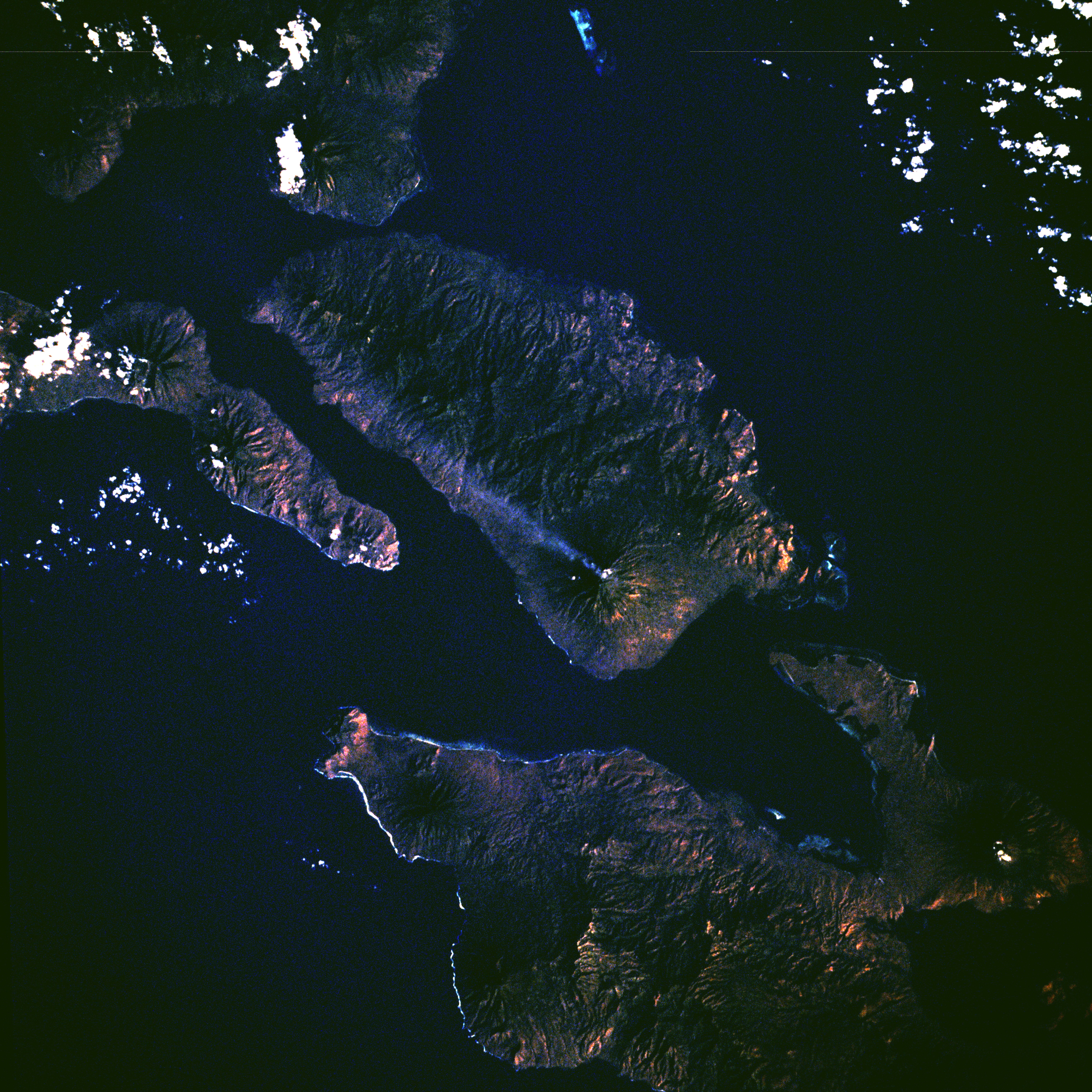 Adonara, viewed from the Space Shuttle, 1983. The eruption plume from stratovolcano Ili Boleng is visible. | |
 | |
| Geography | |
|---|---|
| Location | Lesser Sunda Islands |
| Archipelago | Solor Archipelago |
| Area | 529.75 km2 (204.54 sq mi) |
| Highest elevation | 1,659 m (5443 ft) |
| Administration | |
Indonesia | |
| Province | East Nusa Tenggara |
| Demographics | |
| Population | 129.737 (mid 2021 estimate) |
| Pop. density | 244.0/km2 (632/sq mi) |
| Ethnic groups | Lamaholot |
Administration
The island is divided into eight districts (kecamatan), tabulated below with their areas (in km2) and their populations at the 2010 Census[2] and 2020 census,[3] together with the official estimates as at mid 2021.[4]
| Name | Area in km2 | Population census 2010 | Population census 2020 | Population estimate mid 2021 | Number of villages | Post codes |
|---|---|---|---|---|---|---|
| Adonara Barat (West Adonara) | 79.71 | 11,743 | 13,529 | 13,812 | 18 | 86263 |
| Wotan Ulu Mado | 86.31 | 7,871 | 9,968 | 10,270 | 12 | 86260 |
| Adonara Tengah (Central Adonara) | 42.73 | 10,686 | 13,312 | 13,693 | 13 | 86264 |
| Adonara Timur (East Adonara) | 91.06 | 26,161 | 30,299 | 30,948 | 21 | 86261 |
| Ile Boleng | 49.30 | 13,958 | 17,416 | 17,919 | 21 | 86253 |
| Witihama | 79.43 | 14,140 | 17,460 | 17,945 | 16 | 86266 |
| Kelubagolit | 44.41 | 10,210 | 12,650 | 13,006 | 12 | 86265 |
| Adonara (a) | 56.80 | 9,745 | 11,835 | 12,144 | 8 | 86262 |
| Total Island | 529.75 | 104,514 | 126,469 | 129,737 | 121 |
Note: (a) Adonara District covers only the northern part of Adonara Island ("Adonara Utara").
History
This section does not cite any sources. (November 2007) |
Local history on Adonara is documented from the sixteenth century, when Portuguese traders and missionaries established a post on the nearby island of Solor. By that time Adonara and the surrounding islands were ritually divided between a population of coastal dwellers known as Paji, and a population mainly settling the mountainous inland called Demon. The Paji were susceptible to Islam, while the Demon tended to fall under Portuguese influence. The Paji areas on Adonara contained three principalities, namely Adonara proper (centered on the north coast of the island), and Terong and Lamahala (on the south coast). Together with two principalities on Solor (Lohayong and Lamakera), they constituted a league called Watan Lema ("the five shores"). The Watan Lema allied with the Dutch East India Company (VOC) in 1613, confirmed in 1646. The Adonara principalities had frequent feuds with the Portuguese in Larantuka on Flores, and were not always obedient to the Dutch authorities. In the course of the nineteenth century, the ruler of Adonara (proper) in the north strengthened his position in the Solor Archipelago; by then, he was also the overlord of parts of eastern Flores and Lembata. The Demon areas stood under the suzerainty of the principality of Larantuka, which in turn was under Portuguese rule until 1859, when it was ceded to the Netherlands. The principalities of Larantuka and Adonara (proper) were abolished by the Indonesian government in 1962. Some post-independence local officials trace their roots to past rulers, called raja, of Adonara (proper). These include:

- Foramma, c. 1650
- Boli I, c. 1671–1684
- Eke 1684–1688 (killed by mountain people)
- Gogok, c. 1702
- Wuring (brother of Eke), 1688–1719
- Boli II (son of Wuring), 1719-after 1756
- unknown rulers
- Jou, c. 1815
- Lakabella Jou (son of Jou), c. 1832
- Begu, d. July 28, 1850 (killed)
- Pela(ng) (son of Begu), 1850–1857
- Jou (brother of Pela), 1857–1868
- Kamba Begu (brother of Lakabella), 1868–1893
- Bapa Tuan (son of Kamba Begu), temporary Raja in 1893 for 6 months
- Arkiang Kamba (Arakang; brother of Bapa Tuan, b. 1866), 1893 or 1894 – abdicated December 18, 1930
- Bapa Ana (son of a sister of Kamba Begu), Regent with the title of Kapitan 1930 – December 1, 1935, condemned to life imprisonment 1935 and sent to Kupang
- Bapa Nuhur, (son of Gela, a son of Bapa Tuan, b. 1915), 1941–1947
- Bapa Kaya, (son of Bapa Ana, d. 12/1/1954), Regent 1947–1951
- Mohamad Eke (great-grandson of Raja Jo, 1929 – c. 1985), 1951–1962, first referred as Government Asst during Bapa Kaya's rule and also Kapitan of Adonara
Geography
Adonara Island is a part of the Indonesian regency of East Flores. It can be reached by airplane from Jakarta to Kupang, then by ferry to Larantuka, then by boat.
The administrative centre of Adonara is the town of Waiwerang.
Notes
- Monk, K.A.; Fretes, Y.; Reksodiharjo-Lilley, G. (1996). The Ecology of Nusa Tenggara and Maluku. Hong Kong: Periplus Editions Ltd. p. 8. ISBN 962-593-076-0.
- Biro Pusat Statistik, Jakarta, 2011.
- Badan Pusat Statistik, Jakarta, 2021.
- Badan Pusat Statistik, Jakarta, 2022.
References
- P. Arndt (1938), 'Demon und Padzi, die feindlichen Brüder des Solor-Archipelags', Anthropos 33.
- Robert H. Barnes (1995), 'Lamakera, Solor: Ethnohistory of a Muslim Whaling Village of Eastern Indonesia', Anthropos 90.
- Robert H. Barnes (2004), 'The murder of Sengaji Begu: A turning point in Dutch involvement in the Solor Archipelago', Masyarakat Indonesia 30:2
- Benno M. Biermann (1924), 'Die alte Dominikanermission auf den Solorinseln', Zeitschrift für Missionswissenschaft 14.
- Arend de Roever (2002), De jacht op sandelhout: De VOC en de tweedeling van Timor in de zeventiende eeuw. Zutphen: Walburg Pers.
Authority control | |
|---|---|
| General |
|
| National libraries | |
На других языках
[de] Adonara
Adonara (Bahasa Indonesia: Pulau Adonara, veraltet Adenara, auch Dnara, Lamala, Crama, Sebrão) ist eine indonesische Insel des Solor-Archipels. Sie liegt östlich von Flores, nördlich von Solor und westlich von Lomblen. Im Norden liegt die Bandasee. Mit 1.659 Metern ist Adonara die höchste Insel des Archipels und hat eine Fläche von 497 km².[1]- [en] Adonara
[fr] Adonara
Adonara est une des îles Solor dans les Petites îles de la Sonde en Indonésie. Administrativement, elle appartient au kabupaten de Florès oriental dans la province des petites îles de la Sonde orientales.[it] Adonara
Adonara (indonesiano: Pulau Adonara) è un'isola dell'Indonesia che fa parte delle Piccole Isole della Sonda. L'isola, che conta circa 60.000 abitanti, amministrativamente fa parte della provincia di Nusa Tenggara Orientale.[ru] Адонара
Адонара (индон. Pulau Adonara) — один из островов архипелага Солор, который является частью Малых Зондских островов. В административном отношении входит в состав округа Восточный Флорес индонезийской провинции Восточная Нуса-Тенгара.Другой контент может иметь иную лицензию. Перед использованием материалов сайта WikiSort.org внимательно изучите правила лицензирования конкретных элементов наполнения сайта.
WikiSort.org - проект по пересортировке и дополнению контента Википедии