geo.wikisort.org - Insel
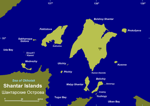
Die Schantar-Inseln (russisch Шантарские острова/Schantarskije ostrowa) sind eine Inselgruppe im Südwesten des Ochotskischen Meeres im Fernen Osten Russlands.
| Schantar-Inseln | ||
|---|---|---|
 | ||
| Gewässer | Ochotskisches Meer | |
| Geographische Lage | 55° 0′ N, 137° 45′ O | |
| ||
| Anzahl der Inseln | 15 | |
| Hauptinsel | Bolschoi Schantar | |
| Gesamte Landfläche | 2500 km² | |
| Einwohner | unbewohnt | |

Der Archipel besteht aus 15 Inseln mit einer Gesamtfläche von etwa 2.500 km². Sie sind von der Küste (Tugurbucht und Tugurhalbinsel) durch schmale Meerengen getrennt, darunter die nur vier Kilometer breite Lindholmstraße zwischen dem Festland und den nächstgelegenen Inseln. Nordwestlich der Inseln erstreckt sich die Udabucht, südöstlich die Akademiebucht. Das Seegebiet zwischen Schantarinseln und Festland wird auch als Schantarmeer (Шантарское море/ Schantarskoje more) bezeichnet.
Die Oberfläche der Inseln ist größtenteils gebirgig, die Küsten steil. Die Inseln sind aus Sandstein und Glimmerschiefern gebildet, welche von Graniten und ultrabasischen Gesteinen durchbrochen wurden.
Die Berge sind von Lärchen- und Tannenwäldern bedeckt, die Gipfelbereiche werden von Zwerg-Kiefer-Knieholz eingenommen.
Administrativ gehören die Schantar-Inseln zum Rajon Tugur-Tschumikan der Region Chabarowsk. Es gibt keine permanente Bevölkerung auf den Schantar-Inseln.
Liste der Schantar-Inseln
| Name | Fläche (km²) |
maximale Höhe (m) |
|---|---|---|
| Bolschoi Schantar (Große Schantar-Insel) | 1.766 | 720 |
| Feklistow-Insel | 372 | 485 |
| Maly Schantar (Kleine Schantar-Insel) | 100 | 224 |
| Belitschi | 70 | 453 |
| Prokofjew-Insel | 40 | 638 |
| Kussow-Insel | 10 | 651 |
| Sacharnaja Golowa | 6 | 266 |
| Juschny | 3 | 182 |
| Ptitschi | 3 | 239 |
| Sewerny | 1 | 134 |
| Sredni | <1 | 93 |
| Utitschi | <1 | 198 |
На других языках
- [de] Schantar-Inseln
[en] Shantar Islands
The Shantar Islands (Russian: Шантарские острова, romanized: Shantarskiye ostrova) are a group of fifteen islands located off the northwestern shore of the Sea of Okhotsk east of Uda Gulf and north of Academy Bay.[1] Most of the islands have rugged cliffs, but they are of moderate height; the highest point in the island group is 720 metres. The name of the island group has its origins in the Nivkh language from the word ч’андь č’and’ meaning "to be white".[2] The islands are currently uninhabited.[fr] Îles Chantar
Les îles Chantar (en russe : Шантарские острова) forment un archipel composé de quinze îles situées dans la partie occidentale de la mer d'Okhotsk[1], près de la Russie continentale. La plupart des îles ont des falaises accidentées, mais elles sont de hauteur modérée; le point culminant du groupe d'îles est de 720 mètres. Les îles, actuellement inhabitées, dépendent administrativement du kraï de Khabarovsk[1].[it] Isole Šantar
Le isole Šantar (in russo Шантарские острова, Šantarskie ostrova) sono un gruppo di quindici isole russe, situate nella parte occidentale del mare di Ochotsk. Amministrativamente appartengono al Territorio di Chabarovsk del Circondario federale dell'Estremo Oriente.[ru] Шантарские острова
Шанта́рские острова — архипелаг в Охотском море у входа в Удскую губу, Тугурский залив и Залив Академии, отделён от материка Шантарским морем и проливом Линдгольма, административно входит в состав Тугуро-Чумиканского района Хабаровского края России. Название, вероятно, произошло от нивхского «ч’андь» — «быть белым»[1].Другой контент может иметь иную лицензию. Перед использованием материалов сайта WikiSort.org внимательно изучите правила лицензирования конкретных элементов наполнения сайта.
WikiSort.org - проект по пересортировке и дополнению контента Википедии