geo.wikisort.org - Insel
Santa Inés (spanisch Isla Santa Inés) ist eine große Insel im Süden Chiles. Geographisch gehört sie zum Feuerland-Archipel, administrativ zur Gemeinde Punta Arenas in der Región de Magallanes y de la Antártica Chilena. Die ursprünglich vom Stamm der Kawesqar besiedelte Insel ist heute unbewohnt.
| Santa Inés | ||
|---|---|---|
| Gewässer | Südpazifik | |
| Inselgruppe | Feuerland | |
| Geographische Lage | 53° 45′ S, 72° 51′ W | |
| ||
| Länge | 92 km | |
| Breite | 55 km | |
| Fläche | 3 688 km² | |
| Höchste Erhebung | 1371 m | |
| Einwohner | unbewohnt | |
 | ||
Geographie
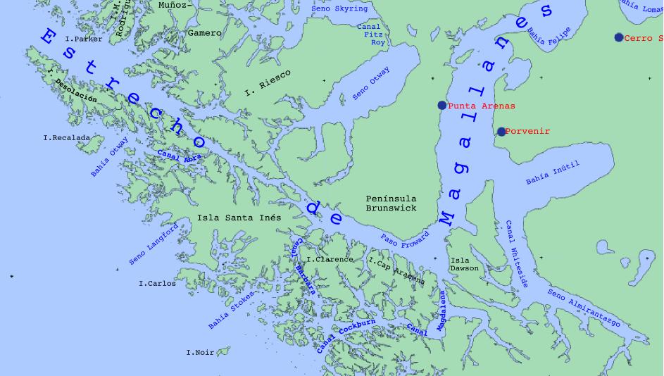
Santa Inés ist mit 3688 km²[1] die größte Insel im Westen Feuerlands und die sechstgrößte Insel Chiles. Sie erstreckt sich entlang der hier nur rund 2 Kilometer breiten Magellanstraße; ihr gegenüber liegen die Insel Riesco sowie die Brunswick-Halbinsel, die südwestlichste Landmasse des patagonischen Festlands. Im Südosten trennt sie der Canal Barbara von der Insel Isla Clarence, im Nordwesten der Canal Abra von der Isla Desolación. Santa Inés ist etwa 90 km lang, bis zu 55 km breit und erreicht eine Höhe von 1370 m[1] über dem Meer. Ihre Küste ist durch zahlreiche Buchten und Fjorde geprägt; in einem dieser Fjorde versteckte sich im südlichen Sommer 1914/15 der deutsche Kreuzer Dresden nach dem Seegefecht bei den Falklandinseln, bevor er in den offenen Pazifik ausbrach.[2]
Einzelnachweise
- UNEP Islands (englisch)
- USGS Glaciers of the Wet Andes (englisch)
На других языках
- [de] Santa Inés (Insel)
[en] Santa Inés Island
Santa Inés Island (Spanish: Isla Santa Inés) is an island in southern Chile, part of the Tierra del Fuego archipelago and of Punta Arenas municipality, lying south west of the Brunswick Peninsula, from which is separated by the Strait of Magellan and minor islands. It is the largest island of Punta Arenas municipality and the third largest of the Tierra del Fuego archipelago, after Isla Grande and Hoste Island. Its shoreline in this area is part of the Francisco Coloane Coastal and Marine Protected Area. The rest of the island is a part of the Alacalufes National Reserve, equalling that Desolación Island and the Córdova Peninsula. This latter is located in front of the island on the other side of the Strait of Magellan and is a peninsula of Riesco Island. The island belongs to the Tierra del Fuego archipelago.[es] Isla Santa Inés
La isla Santa Inés[Nota 1] forma parte del archipiélago de Tierra del Fuego ubicado en la región austral de Chile. Pertenece al sector que para su estudio se ha denominado como de las islas del NO.[Nota 2][fr] Île Santa Inés
L'île Santa Inés est une île appartenant à l'archipel de la Terre de Feu, au Chili. L'île est située à 9,4 km au sud-ouest de la péninsule de Brunswick, dont elle est séparée par le détroit de Magellan. L'île de Santa Inés se trouve sur le territoire de la municipalité de Punta Arenas.[it] Isola Santa Inés
L'isola Santa Inés (in spagnolo Isla Santa Inés) è un'isola dell'estremo australe del Cile, nell'arcipelago della Terra del Fuoco, inquadrata amministrativamente nella Regione di Magellano e dell'Antartide Cilena e nel comune cileno di Punta Arenas.[ru] Санта-Инес (остров)
Санта-Инес[1] (исп. Isla Santa Inés) — остров в западной части архипелага Огненная Земля, расположен в Тихом океане, у южных берегов Южной Америки, административно относится к региону Магальянес и Чилийская Антарктика, Чили.Другой контент может иметь иную лицензию. Перед использованием материалов сайта WikiSort.org внимательно изучите правила лицензирования конкретных элементов наполнения сайта.
WikiSort.org - проект по пересортировке и дополнению контента Википедии