geo.wikisort.org - Insel
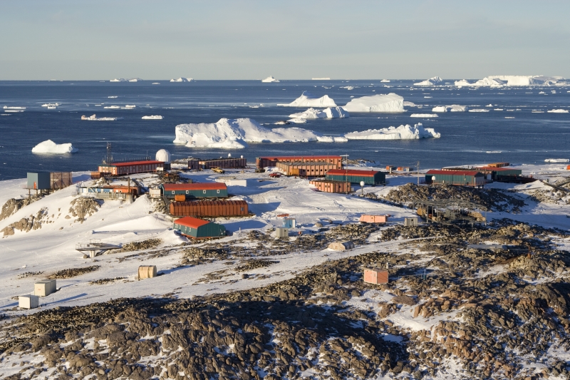
Die Pétrel-Insel (französisch Île des Pétrels) ist eine kleine, 800 m lange und bis zu 45 m hohe Felseninsel vor der Küste des ostantarktischen Adélielands. Sie liegt nordwestlich der Rostand-Insel und ist die größte innerhalb einer Gruppe von Inseln am südöstlichen Ende des Géologie-Archipels.
| Pétrel-Insel | ||
|---|---|---|
 | ||
| Gewässer | D’Urville-See | |
| Inselgruppe | Géologie-Archipel | |
| Geographische Lage | 66° 40′ 0″ S, 140° 1′ 0″ O | |
| ||
| Länge | 910 m | |
| Breite | 630 m | |
| Fläche | 35 ha | |
| Einwohner | 30 86 Einw./km² | |
| Hauptort | Dumont-d’Urville-Station | |

Luftaufnahmen der Insel entstanden bei der US-amerikanischen Operation Highjump (1946–1947). Französische Wissenschaftler kartierten sie im Verlauf einer von 1949 bis 1951 dauernden Forschungsreise und benannten sie nach den Sturmvögeln (französisch Pétrel), die auf dieser Insel brüten. Nachdem die französische Forschungsstation Port Martin bei einem Feuer beschädigt worden war, errichteten hier im Januar 1952 Teilnehmer einer von 1952 bis 1953 dauernden französischen Expedition die Dumont-d’Urville-Station.
Weblinks
- Pétrel Island im Geographic Names Information System des United States Geological Survey (englisch)
- Pétrel Island auf geographic.org (englisch)
На других языках
- [de] Pétrel-Insel
[en] Petrel Island (Antarctica)
Petrel Island (French: Île des Pétrels) is a rocky island, 900 m long and 45 m in elevation, which lies north-west of Rostand Island and is the largest feature in the cluster of islands at the south-eastern end of Geologie Archipelago. It was photographed from the air by U.S. Navy Operation Highjump, 1946–47, charted by the French Antarctic Expedition, 1949–51, and so named by them because numerous snow petrel nests present. In January 1952, following destruction of the Port Martin base by fire, the French Antarctic Expedition under Marret, 1952–53, enlarged the hut on Petrel Island to serve as the new base site. The island is now the site of Dumont d'Urville Station.[fr] Île des Pétrels
L'île des Pétrels est une île revendiquée par la France située dans l'archipel de Pointe-Géologie et faisant partie du district de la terre Adélie des Terres australes et antarctiques françaises (TAAF)[note 1]. L'île des Pétrels est située à 5 kilomètres du continent antarctique et accueille la base antarctique Dumont-d'Urville[1].Другой контент может иметь иную лицензию. Перед использованием материалов сайта WikiSort.org внимательно изучите правила лицензирования конкретных элементов наполнения сайта.
WikiSort.org - проект по пересортировке и дополнению контента Википедии