geo.wikisort.org - Insel
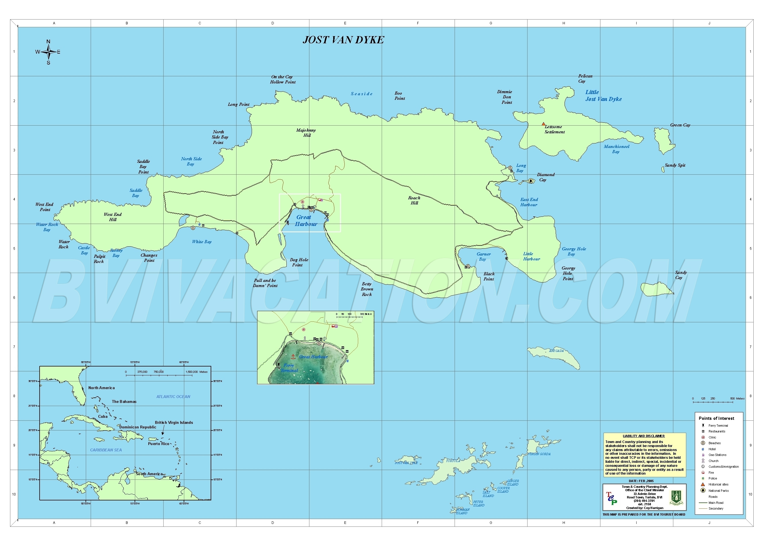
Jost Van Dyke ist eine Insel der Britischen Jungferninseln, ungefähr acht Kilometer nordwestlich der Insel Tortola gelegen. Mit einer Fläche von etwas mehr als acht Quadratkilometern[1] ist sie die kleinste der vier Hauptinseln.
| Jost Van Dyke | ||
|---|---|---|
 | ||
| Gewässer | Karibisches Meer | |
| Inselgruppe | Jungferninseln | |
| Geographische Lage | 18° 27′ 0″ N, 64° 44′ 0″ W | |
| ||
| Länge | 6,5 km | |
| Breite | 2,4 km | |
| Fläche | 8,34 km² | |
| Höchste Erhebung | Majohnny Hill 321 m | |
| Einwohner | 298 (2010) 36 Einw./km² | |
| Hauptort | Great Harbour | |

Geographie
Wie viele ihrer Nachbarinseln ist Jost Van Dyke vulkanischen Ursprungs und hügelig. Die höchsten Punkte der Insel sind der Majohnny Hill mit 321 m und der Rouch Hill mit 313 m.[2] Im südlichen Teil der Insel gibt es drei Ankerbuchten für Segler: die White Bay, Great Harbour und Little Harbour. Jost Van Dyke wird von rund 300 Menschen bewohnt.[3]
Geschichte
Die Insel wurde nach dem niederländischen Piraten Joost van Dyke benannt. Ihre ersten Besiedler waren Quäker, die Anfang des 18. Jahrhunderts auf die Insel kamen, um Zuckerrohr anzubauen.
Persönlichkeiten
- William Thornton (1759–1828), Architekt und Erfinder
- John Coakley Lettsom (1744–1815), Arzt
Weblinks
- Jost Van Dyke. In: The British Virgin Islands. British Virgin Islands Tourist Board
- Maps – Jost Van Dyke. Detailkarte der Insel. In: British Virgin Islands Vacation. Vacation (B.V.I.) Ltd., Februar 2005 (englisch).
Einzelnachweise
- Flächen der Britischen Jungferninseln (Memento vom 4. April 2007 im Internet Archive); abgerufen am 27. Dezember 2017.
- Judith Towle, Susan Zaluski (Hrsg.): An Environmental Profile of the Island of Jost Van Dyke, British Virgin Islands, including Little Jost Van Dyke, Sandy Cay, Green Cay and Sandy Spit. Jost Van Dykes Preservation Society (JVDPS) and Island Resources Foundation (IRF), Jost Van Dyke, BVI September 2009, S. 5, Table 1: Known elevations for Profile islands (englisch, online [PDF; 5,1 MB; abgerufen am 27. Dezember 2017]).
- Virgin Islands 2010 Population and Housing Census Report. (PDF; 2,52 MB) Executive Summary. Government of the Virgin Islands – Central Statistics Office, 1. Dezember 2016, S. 1, abgerufen am 27. Dezember 2017 (englisch).
На других языках
- [de] Jost Van Dyke
[en] Jost Van Dyke
Jost Van Dyke (/ˈjoʊst væn ˈdaɪk/;[2] sometimes colloquially referred to as JVD or Jost) is the smallest of the four main islands of the British Virgin Islands, measuring roughly 8 square kilometres (3 square miles). It rests in the northern portion of the archipelago of the Virgin Islands, located in the Atlantic Ocean and Caribbean Sea. Jost Van Dyke lies about 8 km (5 mi) to the northwest of Tortola and 8 km (5 mi) to the north of Saint John. Little Jost Van Dyke lies off its eastern end.[es] Jost Van Dyke
Jost Van Dyke (a veces coloquialmente llamada JVD o Jost) es la más pequeña de las cuatro islas principales del archipiélago de las Islas Vírgenes Británicas, en el mar Caribe, situada al noroeste de Tórtola. Como muchas de las islas vecinas, es de origen volcánico y montañosa;[1] el punto más alto de la isla es el Majohnny Hill, de 321 metros.[fr] Jost Van Dyke
Jost Van Dyke, familièrement nommée Jost ou JVD, est une île de l'archipel des îles Vierges britanniques. Son nom vient d'un corsaire hollandais, Joost van Dyk.[it] Jost Van Dyke
Jost Van Dyke è un'isola situata nel Mar dei Caraibi appartenente al territorio d'oltremare della Isole Vergini britanniche. La popolazione, secondo il censimento del 2010, ammonta a 298 individui[2], circa l'1% della popolazione totale della dipendenza britannica.[ru] Йост-Ван-Дейк
Йост-Ван-Дейк[1] (англ. Jost Van Dyke) — остров в западной части Британских Виргинских островов. Входит в состав архипелага Виргинские острова Малых Антильских островов.Другой контент может иметь иную лицензию. Перед использованием материалов сайта WikiSort.org внимательно изучите правила лицензирования конкретных элементов наполнения сайта.
WikiSort.org - проект по пересортировке и дополнению контента Википедии