geo.wikisort.org - Insel
Fogo Island (von portugies. Ilha do fogo = „Feuerinsel“) ist eine 254 km²[1] große Insel an der kanadischen Atlantikküste.
| Fogo Island | ||
|---|---|---|
 | ||
| Gewässer | Atlantischer Ozean | |
| Geographische Lage | 49° 37′ N, 54° 12′ W | |
| ||
| Länge | 25,3 km | |
| Breite | 16 km | |
| Fläche | 254 km² | |
| Höchste Erhebung | Lane's Lookout 128 m | |
| Einwohner | 2706 11 Einw./km² | |
| Hauptort | Town of Fogo Island | |
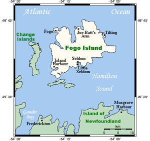 | ||

Sie gehört zur Provinz Neufundland und Labrador und liegt etwa 15 km vor der Nordküste der Hauptinsel in der Notre Dame Bay. Die Insel besitzt eine Ost-West-Ausdehnung von etwa 25 km und verfügt über ein hügeliges, stark bewaldetes Terrain mit überwiegend felsigen Küsten. Höchste Erhebung ist Lane's Lookout an der Ostseite des Hafens, mit einer Höhe von 128 Metern.[2]
Im Jahr 2006 lebten auf Fogo 2706 Einwohner in elf Gemeinden; Hauptort ist die Stadt Town of Fogo Island, die 2011 aus vier Gemeinden der Insel gebildet wurde und (Stand 2011) 2400 Einwohner hat. Der Fischfang, insbesondere Kabeljau, stellt traditionell den wichtigsten Wirtschaftszweig der Insel dar.
Bis etwa 1700 wurde Fogo Island vom indianischen Volk der Beothuk aufgesucht.
Weblinks
- Offizielle Website der Stadt Fogo
Einzelnachweise
- Fogo Island in The Canadian Encyclopedia (englisch)
- Dictionary of Newfoundland English, Toronto 1982–2004, S. 314: Originalangabe 383 feet
На других языках
- [de] Fogo Island
[en] Fogo Island (Newfoundland and Labrador)
Fogo Island (Fogo, Portuguese for "Fire") is the largest of the offshore islands of Newfoundland and Labrador, Canada. The Town of Fogo Island encompasses Fogo, Joe Batt's Arm-Barr'd Islands-Shoal Bay, Seldom-Little Seldom and Tilting, with the unincorporated areas of Fogo Island.[2] It lies off the northeast coast of Newfoundland, northwest of Musgrave Harbour across Hamilton Sound, just east of the Change Islands. The island is about 25 km (16 mi) long and 14 km (8.7 mi) wide. The total area is 237.71 km2 (91.78 sq mi).[es] Isla Fogo (Canadá)
La Isla Fogo (en inglés: Fogo Island) es una isla habitada situada en la costa noreste de Terranova, al norte de Canadá. Ubicada muy cerca de la Isla Change, dispone de una superficie total de 254 km² repartida entre veinticinco kilómetros de largo y catorce en su punto de máximo ancho.[fr] Fogo (Terre-Neuve)
Fogo (du mot portugais pour "feu" ; en anglais Fogo Island) est une île située au nord de Terre-Neuve, au Canada. Elle fait environ 25 kilomètres de longueur pour 14 kilomètres de largeur et une superficie de 237,71 km2.[ru] Фого (остров, Ньюфаундленд и Лабрадор)
Фого (англ. Fogo Island) — остров у побережья острова Ньюфаундленд (Канада).Другой контент может иметь иную лицензию. Перед использованием материалов сайта WikiSort.org внимательно изучите правила лицензирования конкретных элементов наполнения сайта.
WikiSort.org - проект по пересортировке и дополнению контента Википедии