geo.wikisort.org - Insel
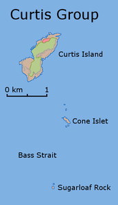
Die Curtis-Gruppe (englisch Curtis Group)[1] ist eine unbewohnte Inselgruppe in der nördlichen Bass-Straße etwa 40 km vor der Südspitze des australischen Festlands. Die Inseln gehören zum australischen Bundesstaat Tasmania.
| Curtis-Gruppe | ||
|---|---|---|
 | ||
| Gewässer | Bass-Straße | |
| Geographische Lage | 39° 29′ S, 146° 38′ O | |
|
| ||
| Anzahl der Inseln | 3 | |
| Hauptinsel | Curtis Island | |
| Gesamte Landfläche | 1,49 km² | |
| Einwohner | unbewohnt | |
Die Inselgruppe besteht aus drei Inseln und zahlreichen Einzelfelsen. Hauptinsel ist das bis 220 m hohe und dürftig bewachsene Curtis Island im Norden. Die 90 m hohe Felsinsel Sugarloaf Rock bildet die südlichste Insel der Gruppe.
Liste der Inseln
![]() Karte mit allen Koordinaten: OSM | WikiMap
Karte mit allen Koordinaten: OSM | WikiMap
| Inselname | Aliasname | Koordinaten | Fläche | Einwohner |
|---|---|---|---|---|
| Curtis Island | 39° 28′ S, 146° 39′ O | 1,44 | - | |
| Cone Island | Cone Islet | 39° 30′ S, 146° 40′ O | 0,04 | - |
| Sugarloaf Rock | 39° 31′ S, 146° 39′ O | 0,01 | - | |
Einzelnachweise
- Curtis Group. In: geonames.org. Abgerufen am 31. Mai 2020 (englisch).
Текст в блоке "Читать" взят с сайта "Википедия" и доступен по лицензии Creative Commons Attribution-ShareAlike; в отдельных случаях могут действовать дополнительные условия.
Другой контент может иметь иную лицензию. Перед использованием материалов сайта WikiSort.org внимательно изучите правила лицензирования конкретных элементов наполнения сайта.
Другой контент может иметь иную лицензию. Перед использованием материалов сайта WikiSort.org внимательно изучите правила лицензирования конкретных элементов наполнения сайта.
2019-2025
WikiSort.org - проект по пересортировке и дополнению контента Википедии
WikiSort.org - проект по пересортировке и дополнению контента Википедии
