geo.wikisort.org - Insel
Cosmoledo ist ein Atoll im Indischen Ozean. Es gehört zur Aldabra-Gruppe, die zu den Outer Islands der Seychellen zählt. Es liegt dabei rund 150 km östlich des Aldabra-Atolls. Etwa 38 Kilometer südsüdöstlich des Cosmoledo-Atolls befindet sich die Astove-Insel.
| Cosmoledo | ||
|---|---|---|
 | ||
| Gewässer | Indischer Ozean | |
| Archipel | Aldabra-Gruppe | |
| Geographische Lage | 9° 42′ S, 47° 36′ O | |
| ||
| Anzahl der Inseln | 16 | |
| Hauptinsel | Menai | |
| Landfläche | 5,2 km² | |
| Lagunenfläche | 145 km² | |
| Einwohner | unbewohnt | |
 | ||

Geographie
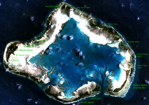
Cosmoledo ist etwa 14,5 km lang und etwa 11,5 km breit. Die Landfläche des Atolls beträgt insgesamt nur 5,2 km², die Fläche der Lagune hingegen etwa 145 km². Das Atoll besteht aus insgesamt 16, dem Saumriff aufliegenden Inselchen (Cays), von denen Menai im Westen mit 2,3 km² und Grande Île im Südosten mit 1,6 km² die größten sind.
Fauna
Cosmoledo ist ein bedeutendes Brutgebiet für Seevögel. So finden sich hier die jeweils größten Kolonien aller drei auf den Seychellen vorkommenden Tölpel-Arten. Die Kolonie der Rotfußtölpel ist gar die größte des Indischen Ozeans. Außerdem kommen Bindenfregattvögel, Arielfregattvögel sowie zahlreiche Arten Seeschwalben, wie beispielsweise die Rußseeschwalbe vor. Auf der Grande Île brüten außerdem Rotschwanz-Tropikvögel, die auf den Seychellen sonst nur auf Aldabra zu finden sind.
Inseln
Die einzelnen Inseln sind im Uhrzeigersinn beginnend bei der nördlichsten aufgelistet:
Norden
Osten
- Île du Trou
- Goelette Island
- Grand Polyte Island
- Petit Polyte Island
- Wizard Island (Île Grande) (mit Fischerhütten) 1,6 km²
Süden
Westen
- Île Moustique
- Île Baleine
- Menai Island (früher Hauptort, heute verlassen) 2,3 km²
- Ile Chauve Souris
- Ile Macaque
- Ile des Rats
- Observation Islet
- Middle Islet
![]() Karte mit allen Koordinaten: OSM | WikiMap
Karte mit allen Koordinaten: OSM | WikiMap
|
Einzelnachweise
- 2010 Sailing directions (Memento vom 8. Mai 2012 im Internet Archive)
- Info on the islands (Memento des Originals vom 13. April 2016 im Internet Archive) Info: Der Archivlink wurde automatisch eingesetzt und noch nicht geprüft. Bitte prüfe Original- und Archivlink gemäß Anleitung und entferne dann diesen Hinweis.
На других языках
- [de] Cosmoledo
[en] Cosmoledo
Cosmoledo Atoll is an atoll of the Aldabra Group and belongs to the Outer Islands of the Seychelles, and is located 1,029 km (639 mi) southwest of the capital, Victoria, on Mahé Island.[fr] Cosmoledo
Cosmoledo, quelquefois écrit Cosmolède, est un atoll inhabité des Seychelles dans l'océan Indien. Il constitue un important lieu de nidification pour plusieurs espèces d'oiseaux et notamment de sterne fuligineuse, dont c'est la plus grande colonie des Seychelles, ainsi que de fous. L'atoll forme avec l'île Astove le groupe Cosmoledo. Avec Aldabra et l'île de l'Assomption, il forme le groupe d'Aldabra.[it] Cosmoledo
Cosmoledo è un atollo dell'Oceano Indiano che fa parte dell'arcipelago delle Seychelles. Si tratta di uno degli atolli compresi nel gruppo di Aldabra, a sua volta riconducibile al gruppo delle Isole Esterne.[ru] Космоледо
Космоле́до (англ. Cosmoledo) — атолл, входящий в группу островов Альдабра Внешних Сейшельских островов. Длина с запада на восток составляет 14,5 км, с севера на юг — 11,5 км. Общая площадь суши — около 5,2 км², а вместе с лагуной — около 152 км². Расположен в 178 км на восток от атолла Альдабра.Другой контент может иметь иную лицензию. Перед использованием материалов сайта WikiSort.org внимательно изучите правила лицензирования конкретных элементов наполнения сайта.
WikiSort.org - проект по пересортировке и дополнению контента Википедии