geo.wikisort.org - Insel
Clarence Island (spanisch Isla Clarence, russisch Остров Шишкова Ostrow Schischkowa) ist die östlichste der Südlichen Shetlandinseln, einer subantarktischen Inselgruppe im Südpolarmeer.
| Clarence Island | ||
|---|---|---|
 | ||
| Gewässer | Südlicher Ozean | |
| Inselgruppe | Südliche Shetlandinseln | |
| Geographische Lage | 61° 13′ S, 54° 6′ W | |
| ||
| Länge | 21,6 km | |
| Breite | 9,5 km | |
| Fläche | 161,6 km² | |
| Höchste Erhebung | Mount Irving 1924 m | |
| Einwohner | unbewohnt | |
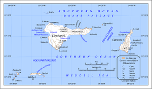 | ||

Die unbewohnte Insel hat die Form eines Dreiecks und ist etwa 18 Kilometer lang (Nord-Südwest-Ausdehnung) sowie 161 km² groß.[1] Die höchste Erhebung bildet der Mount Irving mit einer Höhe von 1924 m über dem Meer,[2] gleichzeitig der höchste Berg der gesamten Inselgruppe.
Die Insel wurde am 4. Februar 1820 von Edward Bransfield entdeckt und nach Wilhelm IV., dem Duke of Clarence, benannt.[2] Bransfield landete bei Cape Bowles an der Südspitze der Insel und erstellte eine grobe Karte. Ein Jahr später wurde die Insel von Fabian von Bellingshausen erneut kartographiert. Von Bellingshausen benannte sie nach Vizeadmiral Alexander Semjonowitsch Schischkow (1754–1841).[3]
Clarence Island wird, wie alle Südlichen Shetlandinseln, von mehreren Staaten beansprucht. Sie fällt jedoch unter den Antarktisvertrag, der bis 2041 keine staatliche Souveränität zulässt.
Quelle
- William James Mills: Exploring Polar Frontiers : A Historical Encyclopedia. ABC-CLIO, Santa Barbara/Denver/Oxford 2003, ISBN 1-57607-422-6 (englisch, eingeschränkte Vorschau in der Google-Buchsuche).
Einzelnachweise
- UNEP Islands (englisch)
- Mills: Exploring Polar Frontiers: A Historical Encyclopedia, S. 148.
- John Stewart: Antarctica – An Encyclopedia. Bd. 1, McFarland & Co., Jefferson und London 2011, ISBN 978-0-7864-3590-6, S. 326 (englisch).
На других языках
- [de] Clarence Island
[en] Clarence Island (South Shetland Islands)
Clarence Island (Russian: остров Шишкова) is the easternmost island in the South Shetland Islands, off the coast of Antarctica. It is claimed by Argentina as part of Argentine Antarctica, by Britain as part of the British Antarctic Territory, and by Chile as part of the Chilean Antarctic Territory. The name dates back to at least 1820 and is now established in international usage, except for Russia, where it has been known as Shishkova Island since its discovery by Russians in 1821.[es] Isla Clarence (Antártida)
La isla Clarence se encuentra en el archipiélago de las islas Shetland del Sur, en la Antártida. Junto a la isla Elefante y otras islas e islotes forman el grupo llamado en la cartografía oficial chilena como islas Piloto Pardo.[1][fr] Île Clarence (Îles Shetland du Sud)
L'Île Clarence est la deuxième île en superficie du groupe d'îles que la cartographie chilienne nomme Îles Piloto Pardo, au nord-est des Îles Shetland du Sud.[it] Isola Clarence
L'isola Clarence (in inglese Clarence Island, in spagnolo Isla Clarence), è un'isola lunga circa 18 chilometri facente parte dell'arcipelago delle Shetland meridionali.[ru] Остров Шишкова
Остров Шишко́ва[1] (также Кла́ренс, англ. Clarence Island) — крайний восточный остров архипелага Южные Шетландские острова. Ближайший из островов — остров Мордвинова (Элефант). Протяженность острова около 20 км (направление север-юг), высшая точка гора Ирвинг[en] (англ. Mount Irving, 1950 метра над уровнем моря).Другой контент может иметь иную лицензию. Перед использованием материалов сайта WikiSort.org внимательно изучите правила лицензирования конкретных элементов наполнения сайта.
WikiSort.org - проект по пересортировке и дополнению контента Википедии