geo.wikisort.org - Insel
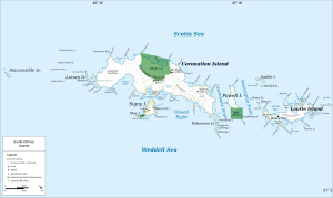
Die Atriceps-Insel (in Argentinien Isla Larga ‚Lange Insel‘) ist eine Insel im Archipel der Südlichen Orkneyinseln. Sie ist die südlichste in der Gruppe der Robertson-Inseln und liegt 5 km südlich des südöstlichen Endes der Coronation-Insel.
| Atriceps-Insel | ||
|---|---|---|
 | ||
| Gewässer | Weddell-Meer | |
| Inselgruppe | Robertson-Inseln, Südliche Orkneyinseln | |
| Geographische Lage | 60° 47′ S, 45° 9′ W | |
| ||
| Einwohner | unbewohnt | |

Der Falkland Islands Dependencies Survey nahm zwischen 1948 und 1949 eine Vermessung vor und benannte sie nach der Blauaugenscharbe (Phalacrocorax atriceps), zu deren Brutgebiet die Insel zählt.
Weblinks
- Atriceps Island im Geographic Names Information System des United States Geological Survey (englisch)
- Atriceps Island auf geographic.org (englisch)
На других языках
- [de] Atriceps-Insel
[en] Atriceps Island
Atriceps Island is the southernmost of the Robertson Islands, lying 5.6 kilometres (3 nmi) south of the south-east end of Coronation Island in the South Orkney Islands of Antarctica. The island has been identified as an Important Bird Area by BirdLife International because it supports a breeding colony of imperial shags (Phalacrocorax atriceps), after which the island was named in 1948–49 by the Falkland Islands Dependencies Survey, with 524 pairs recorded in 1988.[1]Текст в блоке "Читать" взят с сайта "Википедия" и доступен по лицензии Creative Commons Attribution-ShareAlike; в отдельных случаях могут действовать дополнительные условия.
Другой контент может иметь иную лицензию. Перед использованием материалов сайта WikiSort.org внимательно изучите правила лицензирования конкретных элементов наполнения сайта.
Другой контент может иметь иную лицензию. Перед использованием материалов сайта WikiSort.org внимательно изучите правила лицензирования конкретных элементов наполнения сайта.
2019-2026
WikiSort.org - проект по пересортировке и дополнению контента Википедии
WikiSort.org - проект по пересортировке и дополнению контента Википедии