geo.wikisort.org - Insel
Assateague Island ist eine unbewohnte amerikanische Insel in Maryland und Virginia.[1] Die längliche Düneninsel an der Ostküste der Vereinigten Staaten von Amerika ist in Nord-Süd-Richtung 60 km lang. Die Vereinten Nationen haben Assateague Island zum Biosphärenreservat erklärt. Das Innenministerium der Vereinigten Staaten hat die gesamte Insel zum National Natural Landmark erklärt.
| Assateague Island | ||
|---|---|---|
 | ||
| Gewässer | Atlantischer Ozean | |
| Geographische Lage | 38° 5′ N, 75° 13′ W | |
|
| ||
| Länge | 60 km | |
| Einwohner | unbewohnt | |

Auf der Insel finden sich Marschland, Buchten, Sandstrände und Sandbuchten.[2]
Es gibt drei Naturschutzbehörden auf der Insel, die zuständig sind:
- Maryland (beide IUCN-Kategorie V)
- Assateague Island National Seashore
- Assateague State Park (3,2 km²)
- Virginia
- Chincoteague National Wildlife Refuge, 57 km² (IUCN-Kategorie IV).
Auf der Insel existieren wildlebende Assateague-Ponys (Chincoteague).[3]
Die Grenze zwischen den Bundesstaaten auf der Insel ist durch einen hohen Zaun markiert. Die Freiwillige Feuerwehr Chincoteague Volunteer Fire Department in Chincoteague (Virginia) besitzt die größte Herde der Chincoteague-Ponys auf dem Eiland.

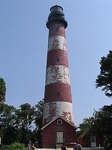
An der Virginia Eastern Shore befindet sich der Leuchtturm Assateague Lighthouse aus den 1830er Jahren mit einer Höhe von 43 m am Südende von Assateague Island. Es ist im National Register of Historic Places eingetragen.
Siehe auch
- National Seashore
Literatur
- John Amrhein jr.: The Hidden Galleon: The True Story of a Lost Spanish Ship and the Legendary Wild Horses of Assateague Island New Maritima Pr 2007
Weblinks
Einzelnachweise
- Kenney, Nathaniel T., „Watermen's Island Home“, National Geographic Magazine, Index (January–June 1980), vol. 157 (June 1980): 812.
- GMCO Maps & Charts. GMCO's Fishing & Recreation Map of Chincoteague-Assateague, Virginia, 2003.
- Assateague Island National Seashore page on wild horses National Park Service.
На других языках
- [de] Assateague Island
[en] Assateague Island
Assateague Island is a 37-mile (60 km) long barrier island located off the eastern coast of the Delmarva Peninsula facing the Atlantic Ocean.[1] The northern two-thirds of the island is in Maryland while the southern third is in Virginia. The Maryland section contains the majority of Assateague Island National Seashore and Assateague State Park. The Virginia section contains Chincoteague National Wildlife Refuge and a one-mile stretch of land containing the lifeguarded recreational beach and interpretive facilities managed by the National Park Service (or NPS).[2] It is best known for its herds of feral horses, pristine beaches and the Assateague Lighthouse. The island also contains numerous marshes, bays, and coves, including Toms Cove.[3] Bridge access for cars is possible from both Maryland and Virginia, though no road runs the full north/south length of the island.[fr] Assateague Island
Assateague Island est une île barrière d'une soixantaine de kilomètres de long formant une barrière entre l'océan Atlantique et les côtes de la Virginie et du Maryland aux États-Unis (péninsule de Delmarva). Elle est réputée pour ses troupeaux de chevaux sauvages et ses plages ayant gardé leur environnement naturel.Другой контент может иметь иную лицензию. Перед использованием материалов сайта WikiSort.org внимательно изучите правила лицензирования конкретных элементов наполнения сайта.
WikiSort.org - проект по пересортировке и дополнению контента Википедии
