geo.wikisort.org - Берег
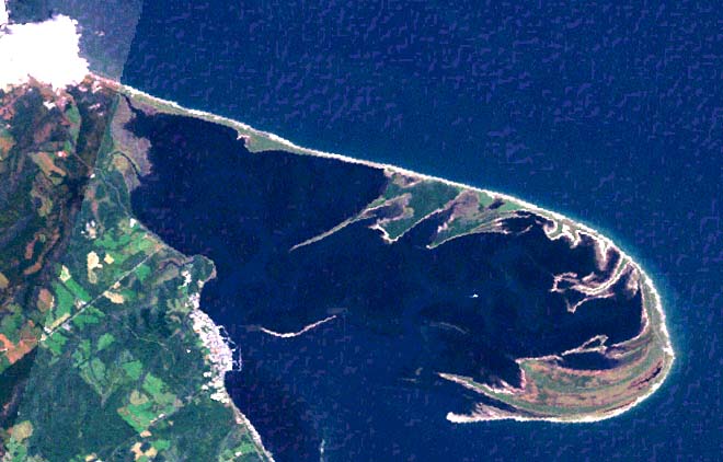
Ноцуке или Ноцуке-ханто (яп. 野付半島 ноцукэ-ханто:) — небольшой полуостров в северо-восточной части острова Хоккайдо, Япония[1]. Имеет длину 28 км и является самой длинной песчаной косой Японии[1].
| Ноцуке | |
|---|---|
| яп. 野付半島 | |
 | |
| Расположение | |
| 43°36′01″ с. ш. 145°17′51″ в. д.HGЯO | |
| Омывающие акватории | Пролив Измены, Ноцуке |
| Страна |
|
| Префектура | Хоккайдо |

Представляет собой песчаную косу, вытянутую с запада на восток в форме крюка, внутри которого расположены бухты-лагуны Ноцуке и Рюдзин. Ноцуке образовался в результате отложений песчаных наносов тёплого течения Соя, а также аллювиальных отложений нескольких горных рек (Тохоро-Гава, Сюмбецу-Гава и др.) которые ныне впадают в бухту Ноцуке-Ван, которая образовалась между полуостровом Ноцуке-Ханто и береговой линией основного массива острова Хоккайдо.
Проседание почвы приводит к образованию характерных ландшафтов из высохших деревьев[1].
Полуостров Ноцуке-Ханто находится в уезде Сибецу округа Немуро. На полуострове расположены две рыбацкие деревни: Энитараусу и Накасибецу. От мыса Весло российского острова Кунашир Ноцуке отделяет пролив Измены шириной 19 километров[2][3].
Примечания
- 野付半島 (яп.). kotobank.jp. Дата обращения: 17 июля 2022. Архивировано 17 июля 2022 года.
- Лист карты K-55-II Головнино. Масштаб: 1 : 200 000. Состояние местности на 1974-81 год. Издание 1984 г.
- Яндекс. Карты. Дата обращения: 15 декабря 2013. Архивировано 15 декабря 2013 года.
На других языках
[en] Notsuke Peninsula
Notsuke Peninsula (野付半島, Notsuke hantō) is a peninsula on the east coast of Hokkaidō, Japan, with its northwestern base in Shibetsu and southeast tip in Betsukai. The name is derived from the Ainu for jawbone, notkeu (ノッケウ), purportedly due to the landform's visual resemblance to that of a whale.[4] The curved peninsula, the longest sandspit in the country, with a length of some 26 kilometres (16 mi) to 28 kilometres (17 mi), extends into the Nemuro Strait, which lies between Shiretoko Peninsula, Nemuro Peninsula, and the disputed island of Kunashiri in the Sea of Okhotsk;[2][5] it was formed by the deposition of sand sediment carried by the currents in the strait, and itself forms and largely encloses Notsuke Bay.[2] There remain on the peninsula traces of Satsumon culture pit dwellings, while during the Edo period samurai were stationed at a checkpoint controlling the crossing to Kunashiri.[1][6] It is said that from the Edo period to the beginning of the Meiji period there was a settlement known as Kiraku (キラク) at the tip of the peninsula, with streets lined with samurai residences and even pleasure quarters, but this is not shown on contemporary maps and is poorly attested in the literature.[5] Prominent features today include withered and eroded stretches of Sakhalin fir (Abies sachalinensis) at Todowara (トドワラ) and Mongolian oak (Quercus crispula) at Narawara (ナラワラ), while to be found in the Notsuke Peninsula Primeval Flower Garden near Notsukezaki Lighthouse towards the eastern tip are the Kamchatka lily, Japanese iris, sea pea, Rosa rugosa, Eriophorum vaginatum, and Hemerocallis esculenta (エゾカンゾウ).[7] The c.15 kilometres (9.3 mi) stretch of Hokkaido Prefectural Road Route 950 (ja) from the base of the peninsula to the nature centre is commonly known as the "Flower Road" (フラワーロード).[7] Together with Notsuke Bay, Notsuke Peninsula has been designated a Ramsar Site,[8] a Special Wildlife Protection Area,[2] and an Important Bird Area,[9] and forms part of Notsuke-Fūren Prefectural Natural Park.[10]- [ru] Ноцуке (полуостров)
Другой контент может иметь иную лицензию. Перед использованием материалов сайта WikiSort.org внимательно изучите правила лицензирования конкретных элементов наполнения сайта.
WikiSort.org - проект по пересортировке и дополнению контента Википедии