geo.wikisort.org - Costa
La Côte Fleurie ("Costa Fiorita") è un tratto di costa affacciata sulla Baia della Senna, nella Manica, della regione francese della Normandia (Francia nord-occidentale) e, più precisamente, del dipartimento del Calvados, in Bassa Normandia, caratterizzato dalla presenza di località balneari mondane.[1][2] Le località più famose della costa sono Deauville, Trouville, Honfleur, Cabourg (stazione balneare dove soggiornò a lungo Marcel Proust[1][2]) e Houlgate.


Geografia
Collocazione
La Côte Fleurie si trova ad est della Côte de Nacre ("Costa di Madreperla"), la costa delle spiagge dello sbarco in Normandia e a sud-ovest di Le Havre e della Côte d'Albâtre ("Costa d'Alabastro"), nonché ad ovest dell'estuario della Senna. I suoi confini sono segnati approssimativamente dall'estuario del fiume Orne ad ovest e da quello della Senna ad est, nonché tra le località di Merville-Franceville-Plage (ad ovest) ed Honfleur (ad est).
Località
- Benerville-sur-Mer
- Blonville-sur-Mer
- Cabourg
- Cricquebœuf
- Deauville
- Dives-sur-Mer
- La Home-Varaville
- Honfleur
- Houlgate
- Merville-Franceville-Plage
- Tourgéville
- Trouville-sur-Mer
- Sallenelles
- Villers-sur-Mer
- Villerville
Punti d'interesse
- Le falesie dette "Vaches Noires" ("Vacche Nere"), nei pressi di Houlgate
- La Città Vecchia di Honfleur
- Il Casinò di Deauville
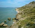 Le falesie dette "Vaches Noires"
 La spiaggia di Houlgate con, sullo sfondo, le falesie dette "Vaches Noires"
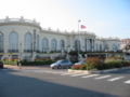 Il Casinò di Deauville


Eventi
- Festival del cinema americano di Deauville, in settembre
Note
- A.A.V.V., Francia, Dorling Kindersley, London - Mondadori, Milano, 1997
- Rainer, Hans-Peter, Guida Marco Polo - Normandia, Mairs Geographischer Verlag, Ostfildern - Hachette, Paris - De Agostini, Novara, 1999
Voci correlate
- Calvados
- Bassa Normandia
- Côte de Nacre
- Costa d'Alabastro
Altri progetti
 Wikimedia Commons contiene immagini o altri file su Côte Fleurie
Collegamenti esterni
- Cœur Côte Fleurie, su coeurcotefleurie.org.
- Deauville - Trouville, su dosville.com.
- Cabourg, su cabourg-pratique.com. URL consultato il 30 agosto 2010 (archiviato dall'url originale il 17 agosto 2010).
- New York Times - Travel > France > Normandy: Normandy’s Quiet Glamour, su nytimes.com.
| Controllo di autorità | VIAF (EN) 315941989 |
|---|
На других языках
[en] Côte Fleurie
The Côte Fleurie (French pronunciation: [kot flœ.ʁi]) (or Flowery Coast) stretches for approximately 40 km (25 mi) between Merville-Franceville-Plage, at the mouth of the Orne river, opposite Ouistreham to the west and Honfleur on the Seine estuary in the east. It forms part of the eastern Basse-Normandie (Lower Normandy) coast on the English Channel to the north of the Pays d'Auge in the Calvados department. The coast between the towns of Trouville and Honfleur, although part of the Côte Fleurie, is named Côte de Grace. Dives-sur-Mer is on the Côte Fleurie but possesses no beach or seafront. The Côte de Nacre continues west from the Touques estuary.[1]- [it] Côte Fleurie
Другой контент может иметь иную лицензию. Перед использованием материалов сайта WikiSort.org внимательно изучите правила лицензирования конкретных элементов наполнения сайта.
WikiSort.org - проект по пересортировке и дополнению контента Википедии