geo.wikisort.org - Coast
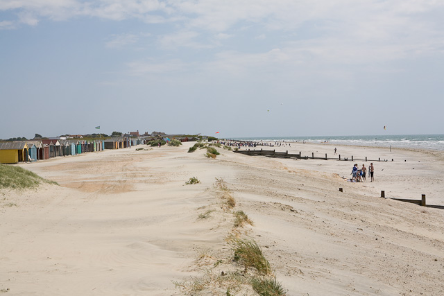
West Wittering is a village and civil parish situated on the Manhood Peninsula in the Chichester district of West Sussex, England. It lies near the mouth of Chichester Harbour on the B2179 road 6.5 miles (10.5 km) southwest of Chichester close to the border with Hampshire. The sandy beach has been described as having excellent water quality.[3]
| West Wittering | |
|---|---|
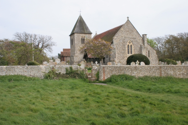 The Parish Church | |
 West Wittering Location within West Sussex | |
| Area | 13.63 km2 (5.26 sq mi) [1] |
| Population | 2,700. 2011 Census[2] |
| • Density | 197/km2 (510/sq mi) |
| OS grid reference | SZ779984 |
| • London | 60 miles (97 km) NE |
| Civil parish |
|
| District |
|
| Shire county |
|
| Region |
|
| Country | England |
| Sovereign state | United Kingdom |
| Post town | CHICHESTER |
| Postcode district | PO20 |
| Dialling code | 01243 |
| Police | Sussex |
| Fire | West Sussex |
| Ambulance | South East Coast |
| UK Parliament |
|
| Website | Parish Council |
The population in 1872 was 616.[4] The 2001 census records a population of 2,684.[1] There is a primary school.[5]
Governance
An electoral ward in the same name exists. This ward includes some of Birdham and at the 2011 Census had a total population of 4,472.[6]
Natural history
Part of the Site of Special Scientific Interest Bracklesham Bay runs in between the coastline in the parish.[7]
Chichester Harbour, a Site of Special Scientific Interest is partly within the parish. This is a wetland of international importance, a Special Protection Area for wild birds and a Special Area of Conservation. The harbour is of particular importance for wintering wildfowl and waders of which five species reach numbers which are internationally important.[8]
Gallery
 East Head sand dunes
 Salt marsh, East Head
 West Wittering beach


Notable residents
- Sarah Ayton, Olympic gold medalist.
- Michael Ball, actor and singer.[9]
- Nicholas Lyndhurst, actor.[10]
- Bevil Mabey (1916-2010), businessman and inventor.
- Keith Richards of the Rolling Stones.[11]
- Lord Nicholas Gordon Lennox, diplomat and son of the Duke of Richmond.
- Sir Henry Royce, engineer, designer of Rolls-Royce cars and aero-engines. From 1917 until his death in 1933.
- Kate Winslet, actress.
Bibliography
The locality is referred to in Giles Cooper's Unman, Wittering and Zigo.[12]
At the mouth of Chichester Harbour lies the little settlement of West Wittering, beautiful and glittering when the sea flows round it at high tide, forlorn and untidy when it is out.
— Clare Jerrold
- J.M. Wilson Imperial Gazetteer of England and Wales 1872
- Clare Jerrold Picturesque Sussex, Hove, Combridge 1932
References
- "2001 Census: West Sussex – Population by Parish" (PDF). West Sussex County Council. Archived from the original (PDF) on 8 June 2011. Retrieved 5 June 2009.
- "Civil Parish population 2011". Retrieved 15 October 2015.
- "Blue Flag Beaches". FEE International. Retrieved 22 October 2017.
- "Historical details".
- "School details".
- "Ward population 2011". Retrieved 17 October 2015.
- "SSSI Citation — Bracklesham Bay" (PDF). Natural England. Retrieved 4 April 2009.
- "SSSI Citation — Chichester Harbour" (PDF). Natural England. Retrieved 7 April 2009.
- "Sunday Times December 23, 2007".
- "Sunday Mirror May 23, 1999".
- Sunday Telegraph 29 October 2007 p14(Issue no 2,420)
- 1971 Walton-on-Thames, Thomas Nelson and Sons Ltd ISBN 0-17-432370-0
External links
![]() Media related to West Wittering at Wikimedia Commons
Media related to West Wittering at Wikimedia Commons
Authority control | |
|---|---|
| General | |
| National libraries | |
Другой контент может иметь иную лицензию. Перед использованием материалов сайта WikiSort.org внимательно изучите правила лицензирования конкретных элементов наполнения сайта.
WikiSort.org - проект по пересортировке и дополнению контента Википедии