geo.wikisort.org - Coast
Waipiʻo Valley is a valley located in the Hamakua District of the Big Island of Hawaiʻi. "Waipiʻo" means "curved water" in the Hawaiian language.[1]


The valley was the capital and permanent residence of many early Hawaiian Aliʻi (chiefs/kings) up until the time of King ʻUmi. This was a place celebrated for its nioi tree (Eugenia reinwardtiana) known as the Nioi wela o Paʻakalana ("The burning Nioi of Paʻakalana"). It was the location of the ancient grass palace of the ancient "kings" of Hawaiʻi with the nioi stands. Kahekili II (king of Maui) raided Waipiʻo in the 18th century and burned the four sacred trees to the ground. The first chief who had a court in this valley was called Kahaimoelea.
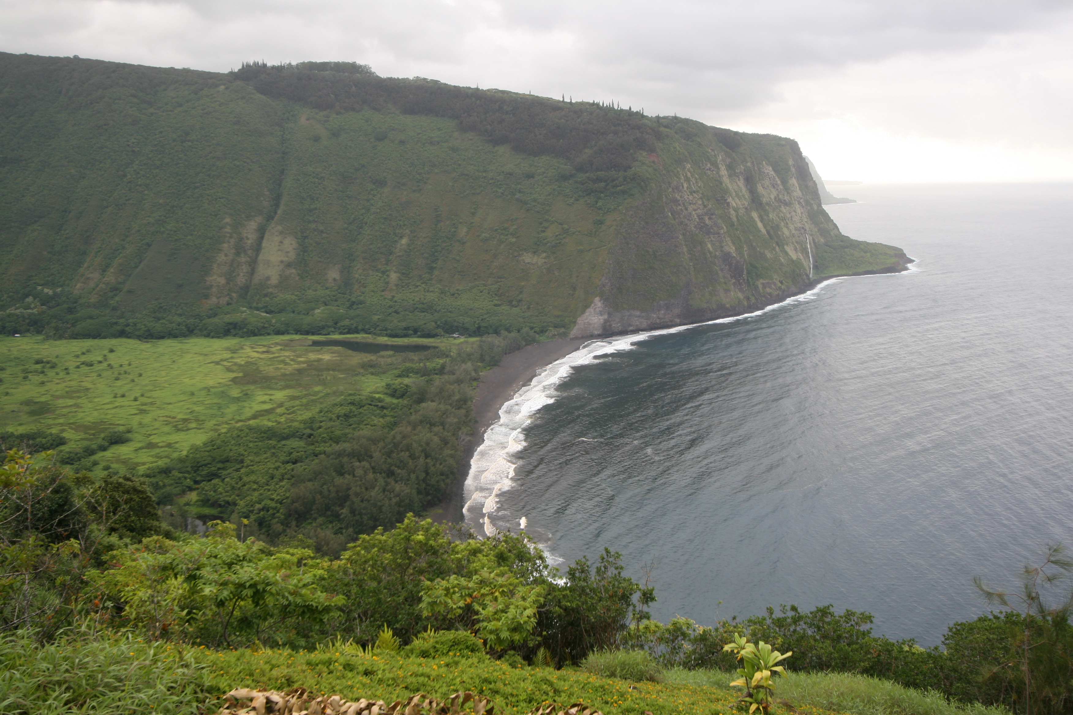
The valley floor at sea level is almost 2,000 ft (610 m) below the surrounding terrain. A steep road leads down into the valley from a lookout point located on the top of the southern wall of the valley. The road rises 800 feet (240 m) in 0.6 miles (1.0 km) at a 25% average grade, with significantly steeper grades in sections. Some portions of the road can reach up to a 45% grade,[2][3][4][5] which would make Waipio Valley Road the steepest in the world, compared to Baldwin Street's 35%. This is a paved public road but it is open only to 4 wheel drive vehicles. It is the steepest road of its length in the United States.[6] The shore line in the valley is a black sand beach, popular with surfers. A few taro farms are located in the valley.[7] Several large waterfalls fall into the valley to feed the river which flows from the foot of the largest falls at the back of the valley out to the ocean.[8]
A foot trail called Waimanu or Muliwai Trail leads down a steep path to the Waimanu Valley, which is only accessible by the trail or by boat. The trail is accessible to hikers, who need a Waimanu camping permit from the state unless they do the trek as a strenuous day hike.[9] At the upper end of the valley, Waimanu Gap at 2,089 feet (637 m) elevation leads to the south end of Waimanu Valley.[10]
The valley was the site of the final scene in the 1995 sci-fi film Waterworld, at which the main characters found dry land.[11]
Waipio Valley Road was closed to visitors from February 25, 2022, to September 19, 2022 "as a precautionary safety measure and to further assess and mitigate the road’s conditions". Officials stated there was roadway and slope failure and the closure includes visitors both in vehicles and on foot. As of September 19, 2022, access to the valley floor with a covered 4WD vehicle is possible again for Big Island residents, county-permitted tour company operators and those seeking to practice their Native Hawaiian traditional or customary rights.[12][13][14]
In Hawaiian folklore
It has a role in local Hawaiian folklore as a place where the gateway to Lua-o-Milu (the Underworld) was hidden from view by sand.[15]
References
- lookup of Waipiʻo on Hawaiian place names web site
- Russo, Carla Herreria. "The 10 Steepest Streets In America". HuffPost. BuzzFeed, Inc. Retrieved 10 May 2022.
- Jennings, Ken. "Is This Hawaiian Street the World's Steepest Road?". Condé Nast Traveler. Condé Nast. Retrieved 19 February 2022.
- "Waipio Valley Road in HI is the steepest road in the USA". Dangerous Roads. dangerousroads.org. Retrieved 3 May 2021.
- Baray, Alexa. "4 Steep U.S. Streets That Will Make Your Palms Sweat". Travel Trivia. Inboxlab, Inc. Retrieved 10 May 2022.
- Summerson, J: "The Complete Guide to Climbing (by Bike)", page 165. Extreme Press, 2007
- Hitt, Christine (April 21, 2019). "Learning Hawaii's history may be key to avoiding cultural insensitivity". Los Angeles Times. Retrieved 2019-04-22.
- History of the Waipiʻo Valley
- "Waipiʻo Valley Beach Hiking Trail | Hawaii Big Island Hikes". Go Hike It. 2017-07-01. Retrieved 2017-08-08.
- Lloyd J. Soehren (2004). "lookup of Waimanu Gap". on Hawaiian place names. Ulukau, the Hawaiian Electronic Library. Retrieved 2010-04-13.
- Locations | Waterworld (1995) on IMDB
- "Waipio Valley Road on the Island of Hawaii Closed to Visitors Indefinitely, Effective February 25". Hawaii Tourism Authority. Hawaii Tourism Authority. 2022-02-25. Retrieved 10 May 2022.
- "Mayor's 02/25/2022 Waipio Valley Road Emergency Rule No. 1". Mayor of Hawaii County. Retrieved February 27, 2022.
- "Mayor's 09/16/2022 Waipio Valley Road Amended Emergency Rule No. 1". Mayor of Hawaii County. Retrieved September 28, 2022.
- Thrum, Thomas (1907). Hawaiian Folk Tales. A. C. McClurg. p. 12.
External links
На других языках
- [en] Waipio Valley
[fr] Vallée de Waipiʻo
La vallée de Waipiʻo est une vallée des États-Unis située sur l'île d'Hawaï, dans l'État du même nom. Elle se trouve sur le versant nord-est du volcan Kohala et débouche directement sur l'océan Pacifique.Другой контент может иметь иную лицензию. Перед использованием материалов сайта WikiSort.org внимательно изучите правила лицензирования конкретных элементов наполнения сайта.
WikiSort.org - проект по пересортировке и дополнению контента Википедии