geo.wikisort.org - Coast
Trinity Beach is a coastal suburb of Cairns in the Cairns Region, Queensland, Australia.[2] At the 2016 census, Trinity Beach had a population of 5,488.[1]
| Trinity Beach Queensland | |||||||||||||||
|---|---|---|---|---|---|---|---|---|---|---|---|---|---|---|---|
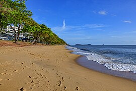
 Trinity Beach looking north. | |||||||||||||||
 Trinity Beach | |||||||||||||||
| Coordinates | 16°47′S 145°42′E | ||||||||||||||
| Population | 5,488 (2016 census)[1] | ||||||||||||||
| Postcode(s) | 4879 | ||||||||||||||
| LGA(s) | Cairns Region | ||||||||||||||
| State electorate(s) | Barron River | ||||||||||||||
| Federal division(s) | Leichhardt | ||||||||||||||
| |||||||||||||||
Geography

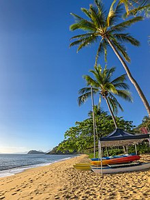
Trinity Beach is approximately 20 kilometres (10 mi) from the Cairns city centre and approximately 6.6 km from Smithfield. Trinity Beach is also a beach stretching for about a mile on the eastern coast of Australia bounded by the Coral Sea.[3] The suburb itself is approximately 2 km wide.
History
Trinity Beach is situated in the Djabugay (Tjapukai) traditional Aboriginal country. [4]
The origin of the suburb name is derived from Trinity Bay.[5]
Trinity Beach State School opened on 30 January 1979.[6]

At the 2011 census, Trinity Beach had a population of 4,734.[7]
Education
Trinity Beach State School is a government primary (P-6) school for boys and girls in Wewak Street. In 2016, the school had an enrolment of 923 students with 60 teaching staff (57 full-time equivalent) and 36 non-teaching staff (22 full-time equivalent).[8]

References
- Australian Bureau of Statistics (27 June 2017). "Trinity Beach (SSC)". 2016 Census QuickStats. Retrieved 5 March 2018.
- "Trinity Beach – suburb (entry 48906)". Queensland Place Names. Queensland Government. Retrieved 10 April 2016.
- "Trinity Beach – beach (entry 41949)". Queensland Place Names. Queensland Government. Retrieved 10 April 2016.
- "First people cultural history". Cairns Regional Council. Retrieved 23 June 2020.
- "T Suburbs" (PDF). Cairns Regional Council. Retrieved 23 June 2020.
- Queensland Family History Society (2010), Queensland schools past and present (Version 1.01 ed.), Queensland Family History Society, ISBN 978-1-921171-26-0
- Australian Bureau of Statistics (31 October 2012). "Trinity Beach (SSC)". 2011 Census QuickStats. Retrieved 5 March 2018.
- "Annual Report 2016" (PDF). Trinity Beach State School. Archived (PDF) from the original on 4 March 2018. Retrieved 5 March 2018.
External links

Другой контент может иметь иную лицензию. Перед использованием материалов сайта WikiSort.org внимательно изучите правила лицензирования конкретных элементов наполнения сайта.
WikiSort.org - проект по пересортировке и дополнению контента Википедии