 Dilapidated building in Skorbeevsky Cape (Мыс Скорбеевский), former military garrison
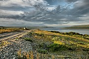 Ozyorko bay
 Tsypnavolok, on the east side
 Shipwreck
geo.wikisort.org - Coast
Rybachy Peninsula (Russian: полуо́стров Рыба́чий, poluostrov Rybachiy; Northern Sami: Giehkirnjárga; Norwegian: Fiskerhalvøya; Finnish: Kalastajasaarento) is the northernmost part of continental European Russia. Its name is translated as "Fisher Peninsula". It is connected with the Sredny Peninsula, "Middle Peninsula" by a thin isthmus. So the peninsula is in fact nearly completely surrounded by water. Administratively, it is included into Pechengsky District of Murmansk Oblast and is within several hours of ride from Murmansk.
This article needs additional citations for verification. (January 2010) |

Main occupations of the population are reindeer herding and (since 2003) petroleum drilling.
History

The peninsula lies in an area where borders were marked relatively late; the Norwegian-Russian border was drawn in 1826, leaving Rybachy on the Russian side of the border. At the time, several Norwegian settlers lived on the peninsula.
After the Russian Revolution, the western parts of Sredny and Rybachy were ceded to Finland. After the Winter War of 1939–1940, Finland ceded them to the Soviet Union by the Moscow Peace Treaty.[1] The Norwegian settlers became "trapped" in Soviet Russia after the revolution; some of their descendants were allowed Norwegian citizenship after the fall of the Iron Curtain.
During the World War II for three years it was an arena of a positional war between Germans and Soviets. The peninsula covered the access to Murmansk and Arkhangelsk, which were the main gates for the Lend-Lease. The front split the peninsula in two parts, both sides having heavily fortified positions.
Before the dissolution of the Soviet Union the territory was heavily militarized because of the immediate vicinity of Norway, a NATO member. Now the military is removed, but in 2005 the territory was still closed to foreigners.


See also
References
Notes
- Administrative-Territorial Division of Murmansk Oblast, p. 53
Sources
- Архивный отдел Администрации Мурманской области. Государственный Архив Мурманской области. (1995). Административно-территориальное деление Мурманской области (1920-1993 гг.). Справочник. Мурманск: Мурманское издательско-полиграфическое предприятие "Север".
External links
Authority control | |
|---|---|
| General |
|
| National libraries | |
На других языках
[de] Fischerhalbinsel
Die Fischerhalbinsel (russisch Полуо́стров Рыба́чий (Poluostrow Rybatschi); finnisch Kalastajasaarento) ist der nördlichste Teil des kontinentalen Europäischen Russland. Die Halbinsel liegt an der Barentssee. Im Süden wird sie durch die Motowski-Bucht begrenzt.- [en] Rybachy Peninsula
[ru] Рыбачий (полуостров)
Рыба́чий (сев.‑саам. Giehkirnjárga — Гиэхкирнйа́рга; фин. Kalastajasaarento — Каластайасааренто; норв. Fiskerhalvøya — Фискерхалвёйа) или Мотка — полуостров на севере России. Административно входит в Печенгский район Мурманской области. Омывается Баренцевым морем, губой Большая Волоковая и Мотовским заливом. Представляет собой плато, круто обрывающееся к морю. Плато сложено глинистыми сланцами, песчаниками и известняками. Наивысшая точка — гора Эйна, 299 м. Тундровая растительность. Прибрежные воды богаты рыбой (сельдью, треской, мойвой и др.)[1]. К югу от полуострова расположен полуостров Средний. С севера в полуостров вдаётся на 3,5 километра относительно крупный залив — Зубовская губа.Текст в блоке "Читать" взят с сайта "Википедия" и доступен по лицензии Creative Commons Attribution-ShareAlike; в отдельных случаях могут действовать дополнительные условия.
Другой контент может иметь иную лицензию. Перед использованием материалов сайта WikiSort.org внимательно изучите правила лицензирования конкретных элементов наполнения сайта.
Другой контент может иметь иную лицензию. Перед использованием материалов сайта WikiSort.org внимательно изучите правила лицензирования конкретных элементов наполнения сайта.
2019-2026
WikiSort.org - проект по пересортировке и дополнению контента Википедии
WikiSort.org - проект по пересортировке и дополнению контента Википедии