geo.wikisort.org - Coast
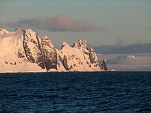
Renier Point (62°36′34″S 59°48′21″W) is a narrow point forming the east extremity of both Burgas Peninsula and Livingston Island in the South Shetland Islands, Antarctica. The feature was known to sealers as Point Renier as early as 1821. The name ‘Pin Point’, given by Discovery Investigations personnel on the Discovery II in 1935, has been rejected in favor of the original name.


Maps
- Chart of South Shetland including Coronation Island, &c. from the exploration of the sloop Dove in the years 1821 and 1822 by George Powell Commander of the same. Scale ca. 1:200000. London: Laurie, 1822.
- South Shetland Islands. Scale 1:200000 topographic map. DOS 610 Sheet W 62 58. Tolworth, UK, 1968.
- Islas Livingston y Decepción. Mapa topográfico a escala 1:100000. Madrid: Servicio Geográfico del Ejército, 1991.
- L.L. Ivanov et al. Antarctica: Livingston Island and Greenwich Island, South Shetland Islands. Scale 1:100000 topographic map. Sofia: Antarctic Place-names Commission of Bulgaria, 2005.
- L.L. Ivanov. Antarctica: Livingston Island and Greenwich, Robert, Snow and Smith Islands. Scale 1:120000 topographic map. Troyan: Manfred Wörner Foundation, 2009. ISBN 978-954-92032-6-4
- Antarctic Digital Database (ADD). Scale 1:250000 topographic map of Antarctica. Scientific Committee on Antarctic Research (SCAR). Since 1993, regularly updated.
- L.L. Ivanov. Antarctica: Livingston Island and Smith Island. Scale 1:100000 topographic map. Manfred Wörner Foundation, 2017. ISBN 978-619-90008-3-0
See also
- Rugged Rocks
References
![]() This article incorporates public domain material from the United States Geological Survey document: "Renier Point". (content from the Geographic Names Information System)
This article incorporates public domain material from the United States Geological Survey document: "Renier Point". (content from the Geographic Names Information System)
На других языках
[de] Renier Point
Der Renier Point (in Chile Punta Pin, in Argentinien Punta Alfiler) ist eine schmale und bis zu 208 m hohe Landspitze, die den östlichen Ausläufer der Livingston-Insel im Archipel der Südlichen Shetlandinseln darstellt. Gemeinsam mit dem Ephraim Bluff auf der gegenüberliegenden Insel Greenwich Island markiert er die südöstliche Einfahrt zur McFarlane Strait.- [en] Renier Point
Текст в блоке "Читать" взят с сайта "Википедия" и доступен по лицензии Creative Commons Attribution-ShareAlike; в отдельных случаях могут действовать дополнительные условия.
Другой контент может иметь иную лицензию. Перед использованием материалов сайта WikiSort.org внимательно изучите правила лицензирования конкретных элементов наполнения сайта.
Другой контент может иметь иную лицензию. Перед использованием материалов сайта WikiSort.org внимательно изучите правила лицензирования конкретных элементов наполнения сайта.
2019-2025
WikiSort.org - проект по пересортировке и дополнению контента Википедии
WikiSort.org - проект по пересортировке и дополнению контента Википедии