geo.wikisort.org - Coast
Redpoint (Scottish Gaelic: An Rubha Dearg) is a small settlement in the north west of Highland, Scotland. It takes its name from Red Point, a low promontory to the south, which marks a turn in the coastline from facing west to south east as it becomes Loch Torridon.
Redpoint
| |
|---|---|
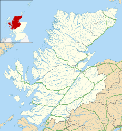 Redpoint Location within the Highland council area | |
| OS grid reference | NG744687 |
| Civil parish |
|
| Council area |
|
| Lieutenancy area |
|
| Country | Scotland |
| Sovereign state | United Kingdom |
| Post town | Gairloch |
| Postcode district | IV21 |
| Dialling code | 01445 |
| Police | Scotland |
| Fire | Scottish |
| Ambulance | Scottish |
| UK Parliament |
|
| Scottish Parliament |
|
Redpoint lies about 10 miles (16 km) south west of Gairloch, at the end of the B8056 road. A path leading from the road leads to a viewpoint from which it is possible (on a clear day) to see almost all of the north eastern coast of the Isle of Skye.
The villages of South Erradale, Opinan and Port Henderson are north along the B8056 coast road.
Scottish electronic music band Boards of Canada released the album Geogaddi in 2002 that contains the track "The Beach at Redpoint".
Текст в блоке "Читать" взят с сайта "Википедия" и доступен по лицензии Creative Commons Attribution-ShareAlike; в отдельных случаях могут действовать дополнительные условия.
Другой контент может иметь иную лицензию. Перед использованием материалов сайта WikiSort.org внимательно изучите правила лицензирования конкретных элементов наполнения сайта.
Другой контент может иметь иную лицензию. Перед использованием материалов сайта WikiSort.org внимательно изучите правила лицензирования конкретных элементов наполнения сайта.
2019-2025
WikiSort.org - проект по пересортировке и дополнению контента Википедии
WikiSort.org - проект по пересортировке и дополнению контента Википедии