geo.wikisort.org - Coast
Poolbeg (Irish: Poll Beag) is an artificial peninsula extending from Ringsend, Dublin, into Dublin Bay.
History
The Poolbeg peninsula was built between the mid 18th century and the present day, starting with the Ballast Office Wall, the first section of the Great South Wall to be built on what was then a sand bar known as the South Bull. As the various sections of the Great South Wall were built, further sand bars formed where the river Liffey left its silt, and these were gradually filled with rubble and built upon.
The name “Poole Begge” referred originally to a tidal pool located out into Dublin harbour and surrounded by sand bars.[1] This was where the Poolbeg lighthouse was built in 1767. The lighthouse was connected to land by the Great South Wall completed in 1795.
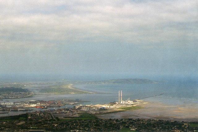
Overview
The Poolbeg “peninsula” is home to a number of landmarks including the Great South Wall, the Poolbeg Lighthouse, the Irishtown Nature Park, the southern part of Dublin Port, an energy-from-waste facility, and a power station, formerly Dublin's main power station, which includes the two landmark chimneys, Dublin’s tallest structures.
Poolbeg Chimneys

The thermal station chimneys at Poolbeg Generating Station are among the tallest structures in Ireland and are visible from most of Dublin city. Number 1 chimney is 207.48m (680 ft 9in) high, while Number 2 chimney is 207.8m (681 ft 9in) high. The chimneys are featured prominently in the video for the song "Pride (In The Name Of Love)" by U2. Dublin City Councillor and historian Dermot Lacey began a process to list the chimneys for preservation to safeguard their future after the Station was to close in 2010.[2][3] This was later refused by the Council Planning Department.

They were subsequently listed as protected structures in July 2014.[4]
21st century plans
New residential area and bridge
The Poolbeg West development consists of 34 hectares of land which has been designated for fast-track planning permission for the construction of nine-storey apartment blocks and up to 100,000sqm of commercial and retail space, including 3,000 homes and commercial space for 8,000 workers.[5]
In June 2016 Dublin City Council announced that it would fast-track construction of a €30 million bridge linking Dublin’s south Docklands with the planned new “urban quarter” on the Poolbeg peninsula.[6]
References
- Map of Dublin in 1685 by Thomas Phillips. British Library. Reproduced in Irish Historic Towns Atlas no. 19, Dublin part II, 2008.
- Plea to save iconic twin stacks. Irish Independent 2007-07-07.
- Poolbeg's chimneys puff their last plumes SADNESS: Landmark now looks doomed despite preservation bid. Evening Herald, 2010-03-31.
- Carbery, Genevieve. "Lit up Poolbeg stacks could be 'as beautiful as Eiffel Tower'". The Irish Times. Dublin. ISSN 0791-5144.
- Stephen McDermott (25 January 2017). "New town with 3000 homes planned for Poolbeg". Dublin Live.
- Olivia Kelly (11 July 2016). "New bridge will connect Poolbeg peninsula to the docklands". The Irish Times. Dublin. ISSN 0791-5144.
Authority control | |
|---|---|
| General |
|
| National libraries | |
Другой контент может иметь иную лицензию. Перед использованием материалов сайта WikiSort.org внимательно изучите правила лицензирования конкретных элементов наполнения сайта.
WikiSort.org - проект по пересортировке и дополнению контента Википедии