geo.wikisort.org - Coast
Matalascañas (Spanish pronunciation: [matalas'kaɲas]; local dialect: [matalaʰ'kaɲa]) is the name of a beach and resort within the Municipality of Almonte, Province of Huelva, in southern Spain. It is known for having an ancient upside down tower on the sand called Torre la Higuera, one of the seven defense towers built by Phillip II in the 16th century to protect the coast from incursions by Turkish and North African corsairs. This locale was still called by the tower's name until the 1970s. The Matalascañas coast line is surrounded by Doñana National Park (also called the Coto de Doñana), and was segregated from it in 1961 to allow the development of a beach-side tourist village. There were environmental protests about this development in the National park. Later, a proposed additional development at La Donana was stopped *. The beach itself is 7 kilometres long with an average width of 80 metres. You can walk unimpeded for several kilometres and even continue into the pristine beaches of Doñana National Park along the Gulf of Cádiz. The mild Mediterranean climate, fine golden sand of the beachfront, mobile dunes, and clean water attract tourists throughout the year; the summer nightlife is attractive to young people.
This article does not cite any sources. (January 2011) |
Matalascañas | |
|---|---|
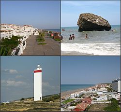
 Top left:Gulf of Cadiz and Matalascañas Beach, view from Nutria area, Top right:Rock of Higuera (Torre de la Higuera), Bottom left:Matalascañas Lighthouse, Bottom right:View of Palmito area in Matalascañas Beach | |
 Location of Huelva | |
 Matalascañas Location in Andalusia | |
| Coordinates: 36°59′36″N 06°32′36″W | |
| Country | |
| Autonomous community | |
| Province | Huelva |
| Comarca | Huelva |
| District | Almonte |
| Elevation | 20 m (70 ft) |
| Population (2012) | |
| • Total | 785 |
| Demonym | Matalascañense/Almonteno(a) |
| Time zone | UTC+1 (CET) |
| • Summer (DST) | UTC+2 (CEST) |
| Postal code | 21760 |
| Dialing code | 959 |
External links
- Coping with Tourists: European Reactions to Mass Tourism
На других языках
[de] Matalascañas
Vorlage:Infobox Ortsteil einer Gemeinde in Spanien/Wartung/localidad- [en] Matalascañas
[es] Matalascañas
Matalascañas o Torre de la Higuera es un núcleo costero perteneciente al término municipal de Almonte en la provincia de Huelva, al suroeste de la comunidad autónoma de Andalucía, en España. Está rodeada completamente por el parque nacional y natural de Doñana, al cual ocasiona graves daños medioambientales. Su población sufre una gran variación entre invierno y verano, por ser principalmente zona de veraneo, siendo la playa más cercana a Sevilla (64 km), unos 99 km por carretera (70 minutos). La urbanización consta de dos iglesias, un centro de salud abierto todo el año y puestos de socorro durante la temporada alta, cuatro farmacias, autobús urbano y apeadero de autobuses interurbanos con conexiones a Huelva, Mazagón, Palos de la Frontera, Almonte y Sevilla. En verano, las conexiones aumentan a municipios cercanos del Condado de Huelva, como La Palma del Condado, Rociana del Condado, Paterna del Campo-Villalba del Alcor y Escacena.Другой контент может иметь иную лицензию. Перед использованием материалов сайта WikiSort.org внимательно изучите правила лицензирования конкретных элементов наполнения сайта.
WikiSort.org - проект по пересортировке и дополнению контента Википедии