geo.wikisort.org - Coast
The Marquesas Keys form an uninhabited island group about 20 miles (32 km) west of Key West, four miles (6 km) in diameter, and largely covered by mangrove forest. They are an unincorporated area of Monroe County, Florida and belong to the Lower Keys Census County Division.[1] They are protected as part of the Key West National Wildlife Refuge.[2] The Marquesas were used for target practice by the military as recently as 1980.


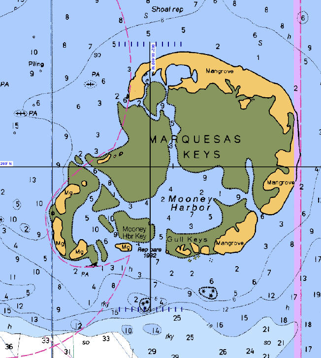 NOAA Nautical chart of the Marquesas Keys: part of Chart No. 11439 "Sand Key to Rebecca Shoal" | |
| Geography | |
|---|---|
| Location | Caribbean |
| Coordinates | 24°34′19″N 82°07′10″W |
| Archipelago | Florida Keys |
| Total islands | 9 |
| Major islands | Entrance Key |
| Area | 6.58 km2 (2.54 sq mi) |
| Administration | |
United States | |
| State | Florida |
| County | Monroe County, Florida |
| Census County Division | Lower Keys |
The total area, including the lagoon, measures 29.37 km2 (11.34 sq mi). The land area, according to the United States Census Bureau, is 6.58 km2 (2.54 sq mi) (exactly 6,579,703 m2), the water area 0.17 km2 (0.066 sq mi) (165,744 m2), giving a combined area of 6.75 km2 (2.61 sq mi) (6,745,447 m2), not counting water areas with connection to the open sea, but including small landlocked lakes on the Keys. The group is located at coordinates 24°34′19″N 82°07′10″W.
The islands are part of the Florida Keys, separated from the rest of the Florida Keys, which are farther east, by the Boca Grande Channel, which is 6 miles (9.7 km) wide until Boca Grande Key, the westernmost of the Mule Keys. Only the Dry Tortugas are farther west, 36 miles (58 km) west of the Marquesas Keys.
The central lagoon is called Mooney Harbor. The northernmost key is the largest and has a strip of sandy beach free of mangrove. In the past it was known as "Entrance Key". It surrounds the lagoon in the north and east. Adjoining in the south are smaller keys such as Gull Keys, Mooney Harbor Key, and finally about four unnamed keys in the southwest corner of the group. Older charts show that two of these keys once were named "Button Island" and "Round Island".[3]
Six miles (10 km) west of the Marquesas Keys is Rebecca Shoal.
The islands are best known for their excellent sport fishing.[citation needed]
See also
- Key West National Wildlife Refuge
- Pseudo-atoll
References
- Marquesas Keys: Blocks 3042 and 3043, Census Tract 9725, Monroe County, Florida United States Census Bureau
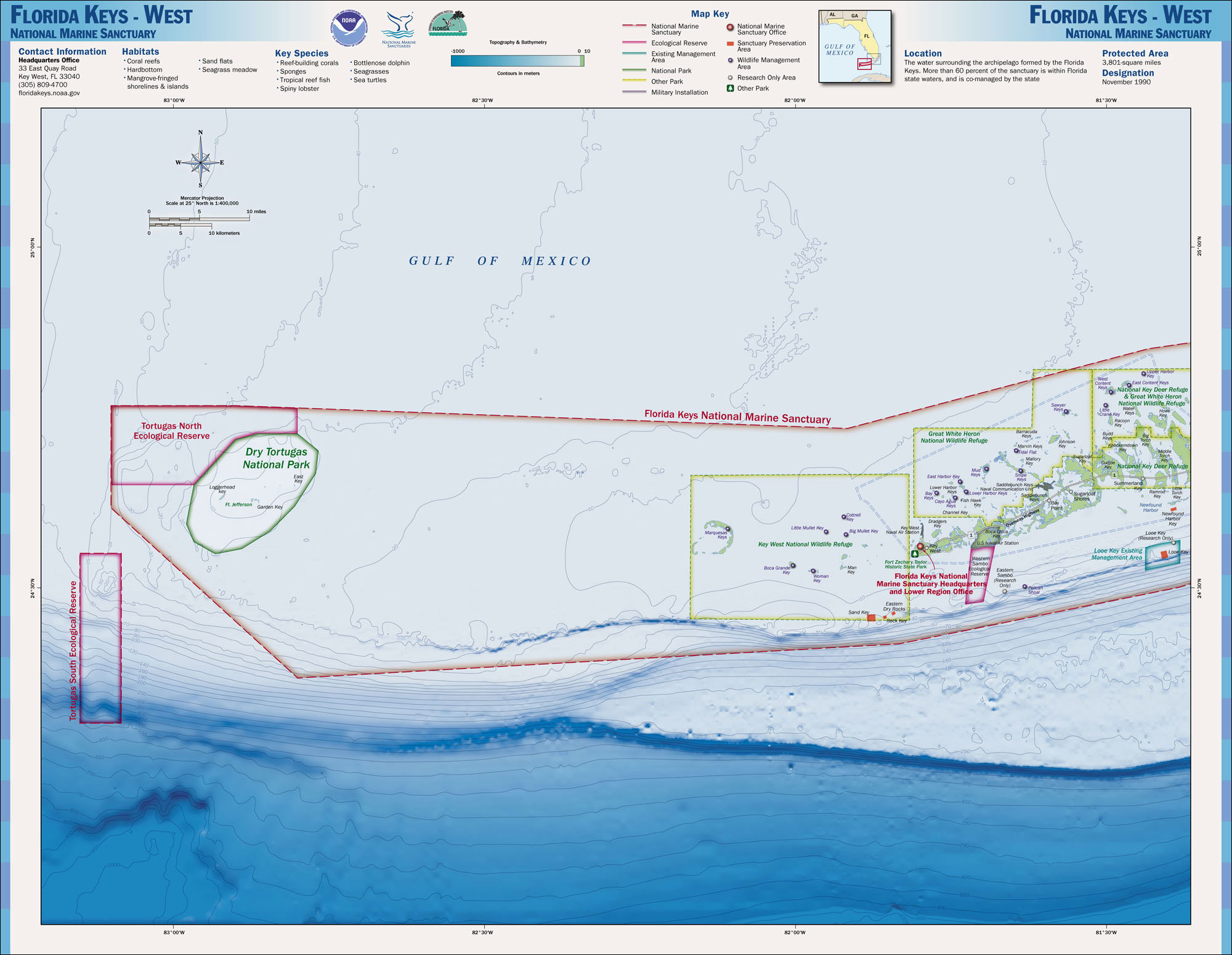
- NOAA National Marine Sanctuary Maps, Florida Keys West
- "Marquesas Keys". keys.FIU.edu. December 11, 2006. Archived from the original on December 11, 2006.
External links
Municipalities and communities of Monroe County, Florida, United States | ||
|---|---|---|
County seat: Key West | ||
| Cities |
|  |
| Village |
| |
| CDPs |
| |
| Unincorporated communities |
| |
| Ghost towns |
| |
| ||
Tallahassee (capital) | ||
| Topics |
|  Seal of Florida |
| History |
| |
| Geography | ||
| Major hurricanes |
| |
| Society |
| |
| Regions |
| |
| Metro areas |
| |
| Largest cities | ||
| Counties |
| |
Authority control | |
|---|---|
| General |
|
| National libraries | |
На других языках
[de] Marquesas Keys
Die Marquesas Keys sind eine zu Florida gehörende, unbewohnte Inselgruppe im Golf von Mexiko. Die Inselgruppe gehört zu den Florida Keys und liegt an deren westlichem Ende etwa 30 km westlich von Key West. Sie sind durch Boca Grande Channel von den anderen Keys getrennt. Lediglich die Dry Tortugas liegen isoliert noch weiter westlich. Administrativ stellen die Marquesas Keys eine „unincorporated area“ des Monroe Countys dar.- [en] Marquesas Keys
[fr] Marquesas Keys
Les Marquesas Keys sont un groupe d'îles des Keys, archipel des États-Unis d'Amérique situé dans le golfe du Mexique au sud-sud-est de la péninsule de Floride. Elles relèvent du Key West National Wildlife Refuge.Другой контент может иметь иную лицензию. Перед использованием материалов сайта WikiSort.org внимательно изучите правила лицензирования конкретных элементов наполнения сайта.
WikiSort.org - проект по пересортировке и дополнению контента Википедии