geo.wikisort.org - Coast
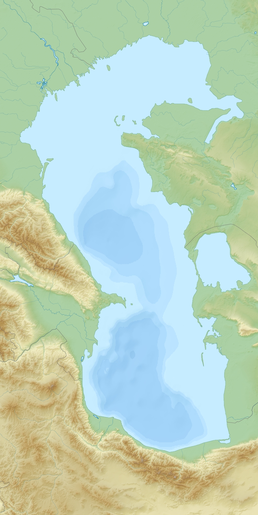
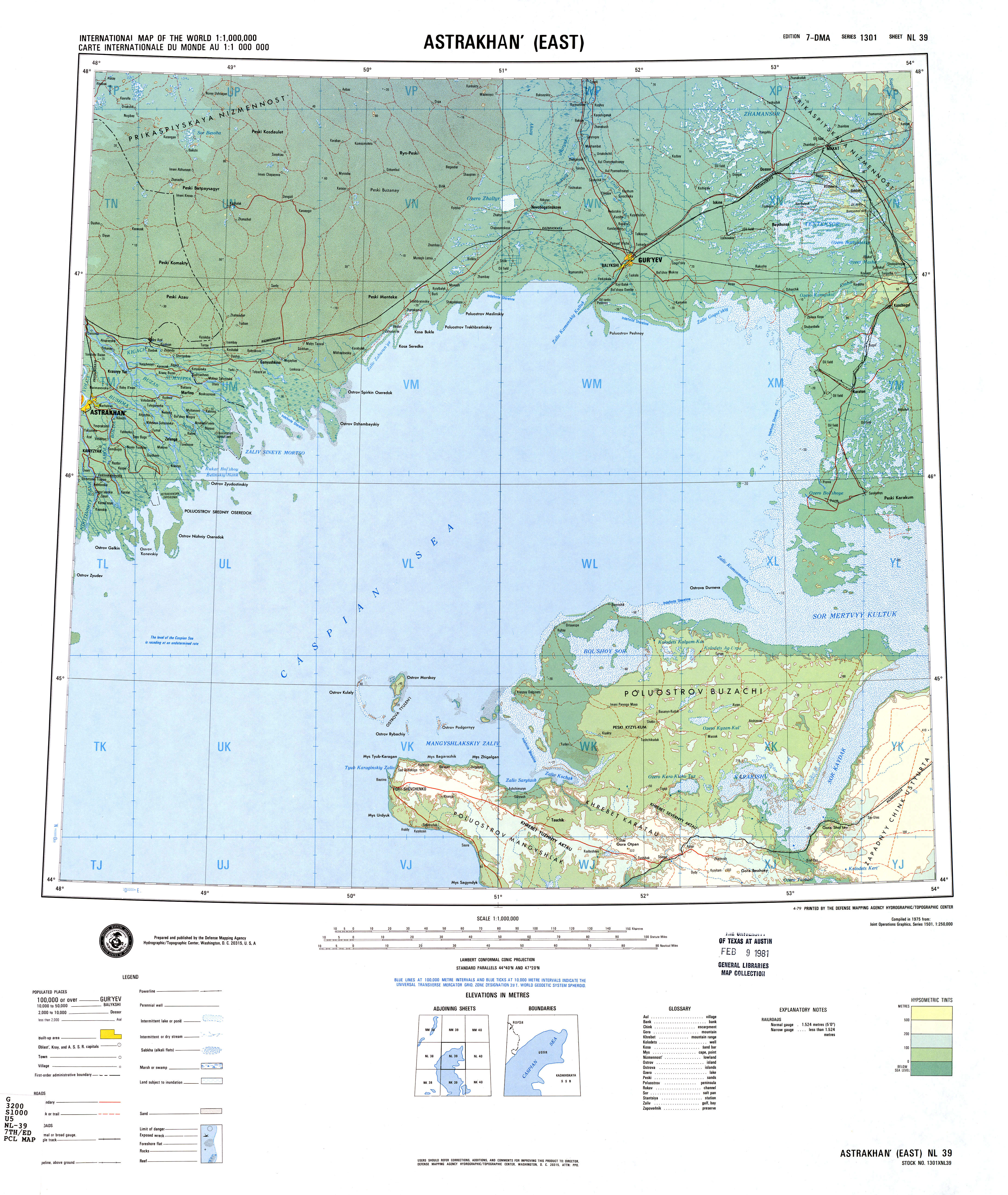
Mangyshlak or Mangghyshlaq Peninsula (Kazakh: Маңғыстау түбегі, romanized: Mañğystau tübegı; Russian: Полуостров Мангышла́к, romanized: Poluostrov Mangyshlák) is a large peninsula located in western Kazakhstan. It borders on the Caspian Sea in the west and with the Buzachi Peninsula, a marshy sub-feature of the main peninsula, in the northeast. The Tyuleniy Archipelago lies off the northern shores of the peninsula.
Mangyshlak Peninsula
Маңғыстау түбегі Полуостров Мангышла́к | |
|---|---|
Peninsula | |
 | |
 Mangyshlak Peninsula | |
| Coordinates: 44°0′N 52°0′E | |
| Country | Kazakhstan |
| Region | Mangystau Region |
| Sea | Caspian Sea |
The area is between desert and semidesert with a harsh continental dry climate. There are no rivers and no fresh water springs. Geologically, the Mangyshlak Peninsula is part of the Ustyurt Plateau. To the north, three mountain ranges stretch across the peninsula, the North and South Aktau Range and the Mangystau Range, with the highest point reaching 555 m.[1] Administratively, the peninsula is in Kazakhstan's Mangystau Province. The largest city, and the capital of the province, is Aktau (formerly Shevchenko).
This peninsula was formerly also known as Sīāhkūh (Persian: سیاهکوه) which means 'Black Mountain' in Persian.[2] The Mangyshlak peninsula was overtaken in 1639 by Kalmyks.[3]
Cartography
The area was mapped by Fedor Ivanovich Soimonov during the Caspian Expedition, which surveyed the Caspian Sea from 1719 to 1727.[1]
 |
 |
Sources
- Igor S. Zonn, Aleksey N Kosarev, Michael H. Glantz & Andrey G. Kostianoy, The Caspian Sea Encyclopedia, p. 285
- de Planhol, Xavier: (1990), CASPIAN SEA i. GEOGRAPHY, Encyclopædia Iranica. Vol.V, Fasc. 1, pp. 48-50
- Michael Khodarkovsky (1 October 2006). Where Two Worlds Met: The Russian State and the Kalmyk Nomads, 1600-1771. Cornell University Press. pp. 83–. ISBN 0-8014-7340-3.
External links
- The wildlife of Mangyshlak (in Russian)
- Kazakhstan Nuclear Facilities: Mangyshlak Atomic Energy Combine at the site of the Nuclear Threat Initiative.
Authority control | |
|---|---|
| General |
|
| National libraries | |
This Kazakhstan location article is a stub. You can help Wikipedia by expanding it. |
На других языках
[de] Mangischlak
Mangischlak (auch Mangyschlak, kasachisch Маңғыстау Mangghystau) ist der Name einer großen Halbinsel am Ostufer des Kaspischen Meeres, die diesem seine charakteristische Bohnenform gibt. Sie gehört zum Verwaltungsgebiet Mangghystau, einer Westprovinz von Kasachstan.- [en] Mangyshlak Peninsula
[ru] Мангышлак
Полуостров Мангышла́к (Мангистау, каз. Маңғыстау) — полуостров на восточном побережье Каспийского моря в Казахстане. Такое же название носит примыкающее к полуострову плато, восточнее переходящее в плато Устюрт. В северной части Мангышлака выделяется полуостров Бузачи, омываемый водами Мангышлакского залива, а также заливов Мёртвый Култук и Кайдак. На западе в Каспийское море вдаётся полуостров Тюб-Караган, с юга примыкает плато Мангышлак с впадинами Карагие (-132 м) и Каунды (-57 м) от уровня моря[1], ещё южнее Мангышлака располагается Казахский залив. На территории полуострова располагается Мангистауская область Казахстана.Другой контент может иметь иную лицензию. Перед использованием материалов сайта WikiSort.org внимательно изучите правила лицензирования конкретных элементов наполнения сайта.
WikiSort.org - проект по пересортировке и дополнению контента Википедии