geo.wikisort.org - Coast
Mackenzie Peninsula (60°45′S 44°48′W) is a steep, rocky peninsula forming the western end of Laurie Island, in the South Orkney Islands, Antarctica. It was first seen and roughly charted by Captain George Powell and Captain Nathaniel Palmer in 1821. It was surveyed in 1903 by the Scottish National Antarctic Expedition under William S. Bruce, who gave this peninsula the maiden name of his wife, Jessie Mackenzie.[1]
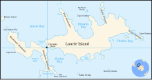
On the northern side of the peninsula is Jessie Bay.[2] On the south is Cape Davidson.[3]
Mount Susini is located at the northwest end of Mackenzie Peninsula.
References
- "Mackenzie Peninsula". Geographic Names Information System. United States Geological Survey, United States Department of the Interior. Retrieved 17 July 2013.
- Ian W. D. Dalziel (1984). Tectonic Evolution of a Forearc Terrane, Southern Scotia Ridge, Antarctica. Geological Society of America. pp. 22–. ISBN 978-0-8137-2200-9.
- Fred G. Alberts (1995). Geographic Names of the Antarctic. National Science Foundation. p. 174.
![]() This article incorporates public domain material from "Mackenzie Peninsula". Geographic Names Information System. United States Geological Survey.
This article incorporates public domain material from "Mackenzie Peninsula". Geographic Names Information System. United States Geological Survey.
This South Orkney Islands location article is a stub. You can help Wikipedia by expanding it. |
На других языках
[de] Mackenzie-Halbinsel
Die Mackenzie-Halbinsel ist steile und felsige Halbinsel, die das westliche Ende von Laurie Island im Archipel der Südlichen Orkneyinseln formt.- [en] Mackenzie Peninsula
Другой контент может иметь иную лицензию. Перед использованием материалов сайта WikiSort.org внимательно изучите правила лицензирования конкретных элементов наполнения сайта.
WikiSort.org - проект по пересортировке и дополнению контента Википедии