geo.wikisort.org - Coast
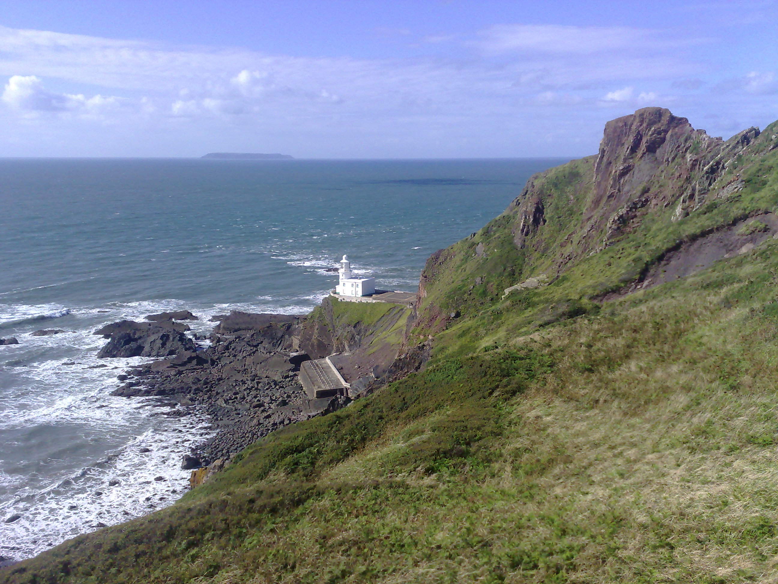
Hartland Point is a 325 ft (99 m) high rocky outcrop of land on the north-western tip of the Devon coast in England. It is three miles (5 km) north-west of the village of Hartland. The point marks the western limit (on the English side) of the Bristol Channel with the Atlantic Ocean continuing to the west. This location was known to the Romans as the "promontory of Hercules".[1]
Lighthouse
Trinity House, the lighthouse authority for England and Wales, has a lighthouse on the tip of the peninsula. The Hartland Point Lighthouse was built in 1874 under the direction of Sir James Douglass.[2] The Grade II-listed tower is 18 metres (59 ft) tall with the lamp being 37 metres (121 ft) above mean sea level. The light could be seen up to 25 miles (40 km) away from the coast.[3] It was blessed by Frederick Temple, Bishop of Exeter, who later became Archbishop of Canterbury. The tower was automated in 1984 and is now controlled from Trinity House Operations Centre at Harwich in Essex.[4] Prior to automation, the lighthouse was built with accommodation for four keepers and their families. The keepers' dwellings have since been demolished to make room for a helipad to be constructed. This was necessary due to the precarious nature of the access road which is liable to frequent rock falls and landslips. Vehicular access is now very difficult and the gates tend to remain locked. The large concrete structures immediately to the south of the lighthouse provided the keepers with fresh water.
In its 2010 Aids to Navigation Review, Trinity House proposed to discontinue the Hartland Point Lighthouse Station on the grounds that Global Positioning Systems are superseding lighthouses as the most important navigation aids.[5][6]
Characteristics
| Light | White group flashing six times every fifteen seconds |
|---|---|
| Fog horn | One five-second blast every minute |
Coastguard

HM Coastguard maintains a small station on the top of the point near the lighthouse. This is now normally unmanned.
The South West Coast Path was formerly an aid to the Coastguard who needed to be able to travel from station to station on foot while being able to keep an eye on the sea to spot for smugglers. The path stays close to the edge of the cliffs on its journey through Hartland Point and it is an ideal way to explore the point, its landmarks and the scenery.
Radar Station

The UK's Ministry of Defence previously had a radar installed on the point and controlled from nearby RAF Hartland Point. The current radar is operated by the UK Civil Aviation Authority for air traffic control.[7] This is used for air traffic control of both military and civilian aircraft. The unusual white-dome-topped structure can be seen from distances of up to 10 miles (16 km) from the point.[8]
MS Johanna

On 31 December 1982 the Panama-registered, Dutch-owned MS Johanna was driven aground on rocks less than 400m from the lighthouse. The cargo ship was carrying wheat from the Netherlands up the Bristol Channel towards Cardiff. Four of the crew were rescued by a helicopter from RAF Chivenor in Devon. Three officers were taken off later in the day by the RNLI lifeboat from Clovelly. The decaying remains of the hull can still be seen.[9]
References
| Wikimedia Commons has media related to Hartland Point. |
- "Hartland Point and Lighthouse". Explore the North Devon Coast. Archived from the original on 29 June 2016. Retrieved 5 July 2016.
- Historic England. "Hartland Point Lighthouse (1309148)". National Heritage List for England. Retrieved 28 July 2019.
- "Hartland Point Lighthouse". Trinity House. Archived from the original on 9 August 2009. Retrieved 31 July 2010.
- "Hartland Point Lighthouse". Photographers Resource. Retrieved 31 July 2010.
- "Hartland Point Lighthouse". Devon History Society. Retrieved 31 July 2010.
- "Hartland lighthouse faces closure". North Devon Journal. 21 January 2010. Archived from the original on 30 June 2012. Retrieved 31 July 2010.
- "Site Name: RAF Hartland Point ('HAT') R8 GCI ROTOR Radar Station". Subterranea Britannica. Retrieved 1 August 2010.
- "Hartland During World War II". Hartland Society. Archived from the original on 3 October 2011. Retrieved 1 August 2010.
- "Hartland Point". Classic Guide. Retrieved 1 August 2010.
На других языках
- [en] Hartland Point
[es] Punta de Hartland
La punta de Hartland (en inglés: Hartland Point) es un alto afloramiento rocoso de 99 metros de altura en la punta noroccidental de la costa de Devon en Inglaterra (Reino Unido). Queda a cinco kilómetros al noroeste del pueblo de Hartland. La punta marca el límite occidental (en el lado inglés) del canal de Bristol con el océano Atlántico siguiendo al oeste. Los romanos llamaron a este sitio el "promontorio de Hércules".Другой контент может иметь иную лицензию. Перед использованием материалов сайта WikiSort.org внимательно изучите правила лицензирования конкретных элементов наполнения сайта.
WikiSort.org - проект по пересортировке и дополнению контента Википедии