geo.wikisort.org - Coast
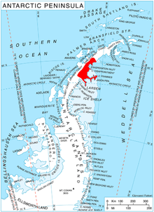
Delusion Point is a point on the south side of the entrance to Spillane Fjord and the northeast side of the entrance to Sexaginta Prista Bay, which marks the east end of Arkovna Ridge that forms the south wall of Crane Glacier, on the east coast of Graham Land. The feature was photographed from the air by Sir Hubert Wilkins on a flight of December 20, 1928, and was named by the Falkland Islands Dependencies Survey, who charted it in 1947.[1]

References
- "Delusion Point". Geographic Names Information System. United States Geological Survey. Retrieved 2012-01-06.
![]() This article incorporates public domain material from the United States Geological Survey document: "Delusion Point". (content from the Geographic Names Information System)
This article incorporates public domain material from the United States Geological Survey document: "Delusion Point". (content from the Geographic Names Information System)
На других языках
[de] Delusion Point
Der Delusion Point (englisch für Einbildungsspitze; spanisch Punta Delusión) ist eine Landspitze an der Oskar-II.-Küste des Grahamlands auf der Antarktischen Halbinsel. Sie bildet am Kopfende des Exasperation Inlet das östliche Ende eines Gebirgskamms, der die Südwand des Crane-Gletschers darstellt.- [en] Delusion Point
Текст в блоке "Читать" взят с сайта "Википедия" и доступен по лицензии Creative Commons Attribution-ShareAlike; в отдельных случаях могут действовать дополнительные условия.
Другой контент может иметь иную лицензию. Перед использованием материалов сайта WikiSort.org внимательно изучите правила лицензирования конкретных элементов наполнения сайта.
Другой контент может иметь иную лицензию. Перед использованием материалов сайта WikiSort.org внимательно изучите правила лицензирования конкретных элементов наполнения сайта.
2019-2025
WikiSort.org - проект по пересортировке и дополнению контента Википедии
WikiSort.org - проект по пересортировке и дополнению контента Википедии