geo.wikisort.org - Coast
Cape May consists of a peninsula and barrier island system in the U.S. state of New Jersey. It is roughly coterminous with Cape May County and runs southwards from the New Jersey mainland, separating Delaware Bay from the Atlantic Ocean. The southernmost point in New Jersey lies on the cape. A number of resort communities line the Atlantic side of the cape, including Ocean City, the most populous community on the cape, The Wildwoods, known for its architecturally significant hotel district, and the city of Cape May, which has served as a resort community since the mid-1700s, making it the oldest such resort in the U.S.
Cape May | |
|---|---|
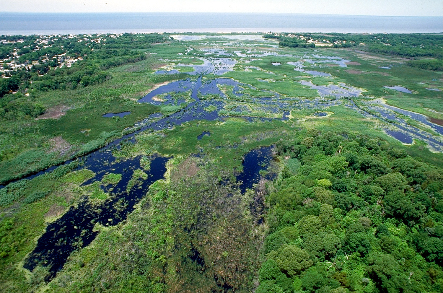 Wetlands on Cape May | |
 Cape May  Cape May  Cape May | |
| Coordinates: 38°57′33″N 74°55′39″W |
It is named for Cornelius Jacobsen Mey, a Dutch explorer who worked for the Dutch East India Company.
Geography and political divisions

The peninsula comprises the municipalities of Middle Township, Avalon, Dennis Township, Stone Harbor, North Wildwood, West Wildwood, Wildwood, Lower Township, Wildwood Crest, North Cape May, West Cape May, Cape May, and Cape May Point. The region is a popular destination for Québécois tourists.[1] It is part of the Southern Shore Region.
The city of Cape May is located on the island (south of the peninsula) and home of the oldest seaside resort in America, with historical roots dating back to the 18th century.[2] The entire city was designated as a National Historic Landmark on May 11, 1976, and many of the buildings throughout the town are original Victorian structures that have been maintained in pristine condition.[3] The basic training camp of the United States Coast Guard is located in Cape May. This facility is the only enlisted basic training center for the United States Coast Guard in the country. Each recruit goes through eight weeks of training before being shipped out.
Cape May is also famous as one of the top birding sites in North America. There are many different parks and birding sites in the area. Due to its location at the southern tip of New Jersey and numerous nature preserves and wildlife refuges, large concentrations of birds can be found in Cape May, especially during spring and fall migration. The Cape May Bird Observatory acts as the central coordinator of birding activities in Cape May, including the World Series of Birding, held in Cape May (and throughout New Jersey) each May.
Cape Island
Cape Island is a man-made island at the southern tip of Cape May County, which consists of Cape May, Cape May Point, West Cape May and portions of Lower Township. The island is separated from the mainland and the rest of Cape May County by the man-made Cape May Canal, Cape Island Creek and Cape May Harbor which cut it off from the rest of the Cape May Peninsula.
Cape May Canal is a 2.9-nautical mile (3.3 mi; 5.4 km) waterway connecting Cape May Harbor to the Delaware Bay, at the southern tip of Cape May County, New Jersey.[4] Before the canal was built, "Cape Island" referred to the site of the City of Cape May, southeast of Cape Island Creek, a tidal "creek" and marsh that has been partly filled in at its southern end.[5]
History
The Kechemeche tribe of the Lenni Lenape were the first residents of the area that historians know of.[6] Each summer, the Native Americans vacationed at what is now Cape May to escape the summer heat. While there, they fished, hunted, and collected fruits before the advent of autumn mandated the return to their inland villages.[7]
The first European to catch a glimpse of Cape May was navigator Henry Hudson and 18 of his crew mates on the Halve Maen. On August 28, 1609, while searching for the Northwest Passage, Hudson decided to sail up the unexplored Delaware Bay. Several miles up the coast, strong tides pulled the Halve Maen to a sandbar, and the crew was stranded until thunderstorms and wind aided the ship around the Cape May peninsula. This event was recorded by Hudson's first mate, Robert Juet.[8]
News of his discovery sparked a search for the location of a new trading post. English explorer Samuel Argall explored the bay and named it for the governor of the Virginia Colony, Lord De La Warr.[9] Not to be outdone, the Dutch also sent some navigators to look for suitable sites for trading ventures. Among the band of explorers were Cornelis Henderson, Adriaen Block, and Cornelis Jacobsen Mey.[10]
The recorded history of Cape May stretches back to 1620, when Captain Cornelius Jacobsen Mey surveyed and named the area for himself. It later grew from a small settlement to the large beach resort it has been since the 19th century.[6] The City of Cape May asserts that its status as a vacation spot began in 1766,[6] with Philadelphians coming in by stagecoaches, ships, and horse-drawn wagons, and that the Kechemeche Lenape had primarily used the land for hunting beforehand. Hotels were already on Cape May as of 1834.[6]
In 1782 during the American Revolutionary War, the young Continental Navy Lieutenant Joshua Barney fought with a British squadron at Cape May and Delaware Bay. Barney's force of three sloops defeated a Royal Navy frigate, a sloop-of-war and a Loyalist privateer. The battle ended with the loss of two British vessels and one American sloop.
See also
- Cape May County
- Cape May Light
- Cape May Historic District
- National Register of Historic Places listings in Cape May County, New Jersey
References
- Lawlor, Julia. "Back From the North, and the Water Feels Magnifique", The New York Times, August 5, 2007. Accessed September 29, 2007. "Tourism officials and hotel owners in this Cape May County resort began noticing an increase in the number of French Canadian visitors in the summer of 2005, after a prolonged scarcity caused by a weak Canadian dollar and high unemployment in Quebec."
- Howard, Beth. "A Sampling Of House Tours Across Nation", The New York Times, March 29, 1987. Accessed October 12, 2007. "The nation's oldest seashore resort, Cape May, N.J., is noted for its Victorian gingerbread architecture."
- List Of National Historic Landmarks By State Archived August 24, 2009, at the Wayback Machine, National Park Service, July 2007. Accessed October 12, 2007.
- U.S. Army Corps of Engineers, Philadelphia, PA. (2009). "Cape May Canal, New Jersey." Archived 2013-02-15 at the Wayback Machine
- See Aerial Tour of Cape May, NJ Archived September 10, 2011, at the Wayback Machine, retrieved September 21, 2011.
- "Cape May History". City of Cape May. 2009. Archived from the original on 6 October 2011. Retrieved 10 October 2011.
- Santelli, Robert (2006). Guide to the Jersey Shore: From Sandy Hook to Cape May (7th ed.). Guilford, Connecticut: Insiders' Guides. p. vi. ISBN 0-7627-4038-8. OCLC 22509728.
- Dorwart, Jeffery M. (1992). Cape May County, New Jersey: The Making of an American Resort Community. New Brunswick, New Jersey: Rutgers University Press. p. 1. ISBN 0-8135-1783-4. OCLC 24377299.
- Argall believed that the Delaware Bay was the northern boundary of the Virginia Colony.
- Dorwart, Jeffery M. (1992). Cape May County, New Jersey: The Making of an American Resort Community. New Brunswick, New Jersey: Rutgers University Press. p. 2. ISBN 0-8135-1783-4. OCLC 24377299.
External links
- Cape May history
- Cape May Lighthouse
- Cape May Chamber of Commerce
- Cape May city website
- Historic Cold Spring Village
На других языках
- [en] Cape May
[ru] Кейп-Мей (мыс)
Мыс Кейп-Мей[1] (англ. Cape May) — полуостров на восточном побережье США, южная оконечность мыса является самой южной точкой штата Нью-Джерси. Мыс проходит от южной части континентальной территории штата и отделяет залив Делавэр от Атлантического океана. Назван в честь голландского мореплавателя Корнелиуса Якобсена Мея.Другой контент может иметь иную лицензию. Перед использованием материалов сайта WikiSort.org внимательно изучите правила лицензирования конкретных элементов наполнения сайта.
WikiSort.org - проект по пересортировке и дополнению контента Википедии