geo.wikisort.org - Coast
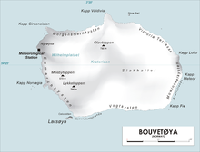
Cape Lollo (Norwegian: Kapp Lollo), located at 54°25′S 3°29′E, is a cape which forms the northeastern extremity of Bouvetøya in Norway. It was first charted in 1898 by a German expedition under Carl Chun, and was recharted and named in December 1927 by a Norwegian expedition under Captain Harald Horntvedt.[1][2]
See also
- Spiess Rocks
References
- "Cape Lollo". Geographic Names Information System. United States Geological Survey. Retrieved 2013-06-28.
- "Prof. Dr. phil., Dr. med. h. c. Carl Chun". University of Leipzig. Retrieved October 1, 2016.
![]() This article incorporates public domain material from the United States Geological Survey document: "Cape Lollo". (content from the Geographic Names Information System)
This article incorporates public domain material from the United States Geological Survey document: "Cape Lollo". (content from the Geographic Names Information System)
This Bouvet Island location article is a stub. You can help Wikipedia by expanding it. |
На других языках
[de] Kap Lollo
Kap Lollo (norwegisch Kapp Lollo) ist ein kleines Kap an der Ostküste der Bouvetinsel. Es befindet sich in gut 5 bis 6 km Entfernung von Kap Valdivia, dem nördlichsten Punkt der Insel, ist im Gegensatz zu diesem aber weniger charakteristisch ausgeprägt. Südlich davon erstreckt sich die Mowinckel-Küste, und nordwestlich die Victoria-Terrasse-Küste.- [en] Cape Lollo
Текст в блоке "Читать" взят с сайта "Википедия" и доступен по лицензии Creative Commons Attribution-ShareAlike; в отдельных случаях могут действовать дополнительные условия.
Другой контент может иметь иную лицензию. Перед использованием материалов сайта WikiSort.org внимательно изучите правила лицензирования конкретных элементов наполнения сайта.
Другой контент может иметь иную лицензию. Перед использованием материалов сайта WikiSort.org внимательно изучите правила лицензирования конкретных элементов наполнения сайта.
2019-2026
WikiSort.org - проект по пересортировке и дополнению контента Википедии
WikiSort.org - проект по пересортировке и дополнению контента Википедии