geo.wikisort.org - Coast
Cape Espiritu Santo, also known as Cape Espiritu Santo Mountains,[1] is the northeastern point of the Northern Samar and the northernmost point of Samar Island. It was named Cabo Espiritu Santo by early European explorers, since it was discovered on the Feast of the Holy Spirit.[2] It is also the first land sighted by the Spaniards when sailing from Nueva España, marks the end of their long sailing as they approaches the land and coast of the Ibabaw in the Philippines. Spanish navigators noted the mountains' value as they are visible 40 miles out to sea.[3] There are two prominent summits in this location. One rises 1,481 ft (451.41 m) and the other 1,457 ft (444.09 m).[4]
 View of Cape Espiritu Santo from the Pacific Ocean
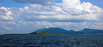 Photo of Cape Espiritu Santo taken 3 km (1.86 mi) West of Batag Island
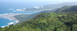
 Cape Espiritu Santo falls


Cape Espiritu Santo
Magsasanga (16th century) | |
|---|---|
 View of Cape Espiritu Santo or the Northeastern tip of Samar island | |
 | |
| Coordinates: 12.535°N 125.189°E | |
| Location | |
| Offshore water bodies | Pacific Ocean |
References
- United States Board on Geographic Names (1989). Gazetteer of the Philippines: Names Approved by the United States Board on Geographic Names. Defense Mapping Agency. p. 471. Retrieved 1 September 2022.
- Alcina, Ignacio Francisco (1668). Historia de las islas e indios de Bisayas. pp. 161 book 1: Chapter 5.
- U. S. Coast and Geodetic Survey (1940). United States Coast Pilot: Philippine Islands. U.S. Government Printing Office. p. 178. Retrieved 1 September 2022.
- United States Defense Mapping Agency Hydrographic Center (1975). Sailing Directions for the Philippine Islands, Volume II: Central Islands, Including Eastern Negros, Southern Samar, and Northern Mindanao. Defense Mapping Agency, Hydrographic Center. p. 299. Retrieved 1 September 2022.
This article about a location in Eastern Visayas region is a stub. You can help Wikipedia by expanding it. |
Другой контент может иметь иную лицензию. Перед использованием материалов сайта WikiSort.org внимательно изучите правила лицензирования конкретных элементов наполнения сайта.
WikiSort.org - проект по пересортировке и дополнению контента Википедии