geo.wikisort.org - Coast
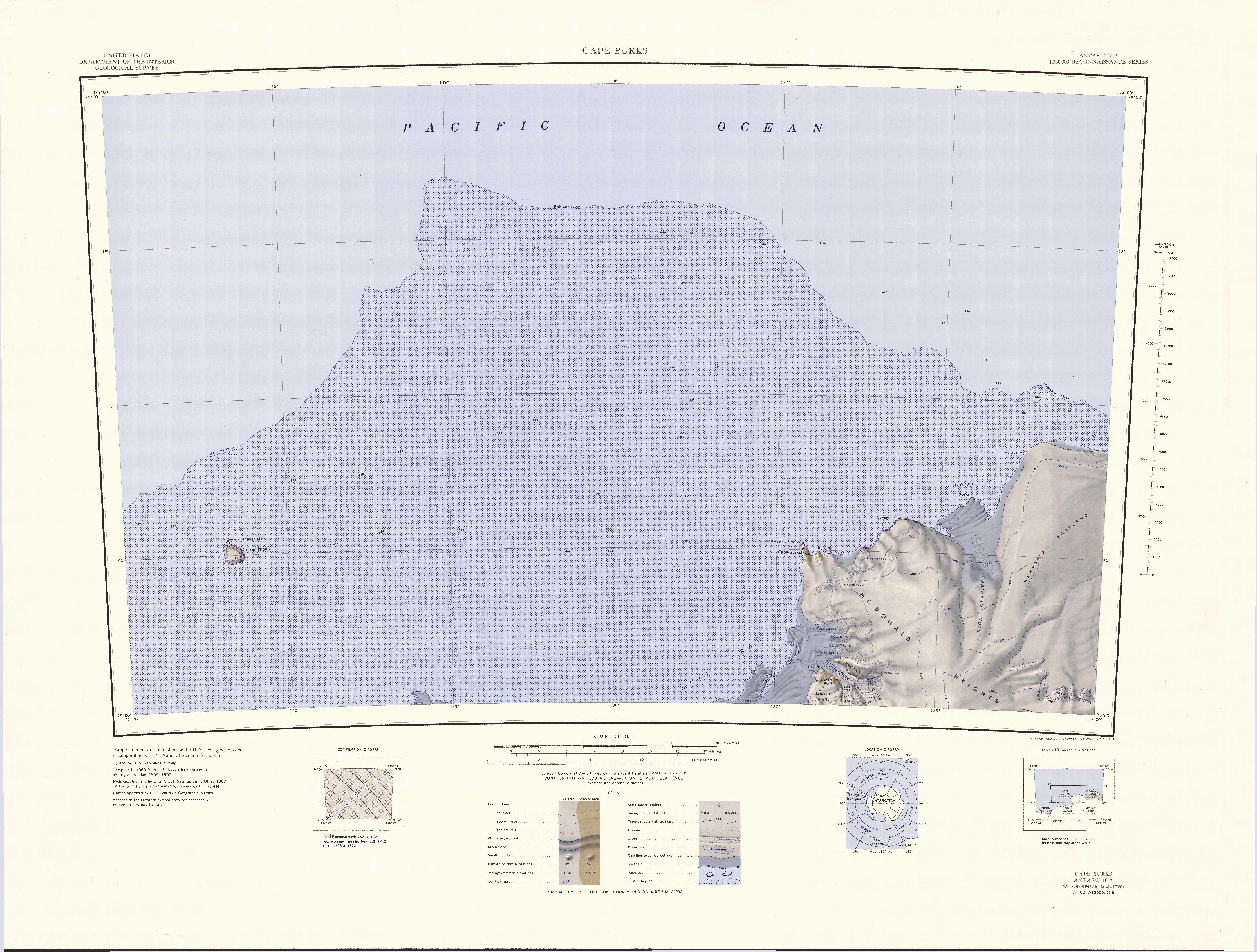
Cape Burks is a prominent rock cape, the northwestern seaward extension of McDonald Heights, marking the east side of the entrance of Hull Bay on the coast of Marie Byrd Land. The cape was sighted and mapped from the USS Glacier, January 31, 1962, and was named for Lieutenant Commander Ernest Burks, U.S. Navy, senior helicopter pilot on the Glacier and the first person to set foot on the cape.
Russkaya Station was established on Cape Burks by the Soviet Union in 1980.
Further reading
- Ute Christina Herzfeld, Atlas of Antarctica: Topographic Maps from Geostatistical Analysis of Satellite Radar Altimeter Data, P 194
- David G. Ainley, The Ad lie Penguin: Bellwether of Climate Change, P 78
- D.A. Tkacheva, E.V. Mikhalsky, N.M. Sushchevskaya, E.L. Kunakkuzin, S.G. Skublov, S.A. Sergeev, Mountain Age and Geochemistry of the Cape Burks Gabbroids (Russkaya Station Area, West Antarctica), Geokhimiya, 2018, No. 7, 2018, DOI: 10.1134/S001670291807011X
- E. V. Abakumov, Particle Size Distribution in Soils of West Antarctica, ISSN 1064-2293, Eurasian Soil Science, 2010, Vol. 43, No. 3, pp. 297–304, DOI: 10.1134/S1064229310030075, See P. 298
References
 This article incorporates public domain material from the United States Geological Survey document: "Burks, Cape". (content from the Geographic Names Information System)
This Marie Byrd Land location article is a stub. You can help Wikipedia by expanding it. |
На других языках
[de] Kap Burks
Kap Burks ist ein markantes Felsenkap an der Grenze zwischen der Ruppert-Küste im Westen und der östlich liegenden Hobbs-Küste im westantarktischen Marie-Byrd-Land. Das Kap ist die nordwestliche Verlängerung der McDonald Heights an der Ostseite der Einfahrt zur Hull Bay.- [en] Cape Burks
Текст в блоке "Читать" взят с сайта "Википедия" и доступен по лицензии Creative Commons Attribution-ShareAlike; в отдельных случаях могут действовать дополнительные условия.
Другой контент может иметь иную лицензию. Перед использованием материалов сайта WikiSort.org внимательно изучите правила лицензирования конкретных элементов наполнения сайта.
Другой контент может иметь иную лицензию. Перед использованием материалов сайта WikiSort.org внимательно изучите правила лицензирования конкретных элементов наполнения сайта.
2019-2026
WikiSort.org - проект по пересортировке и дополнению контента Википедии
WikiSort.org - проект по пересортировке и дополнению контента Википедии