geo.wikisort.org - Coast
Cape Bon ("Good Cape") is a peninsula in far northeastern Tunisia, also known as Ras at-Taib (Arabic: الرأس الطيب),[1] Sharīk Peninsula, or Watan el Kibli;[2] Cape Bon is also the name of the northernmost point on the peninsula, also known as Ras ed-Dar, and known in antiquity as the Cape of Mercury (Latin: Promontorium Mercurii).[3]
Cape Bon | |
|---|---|
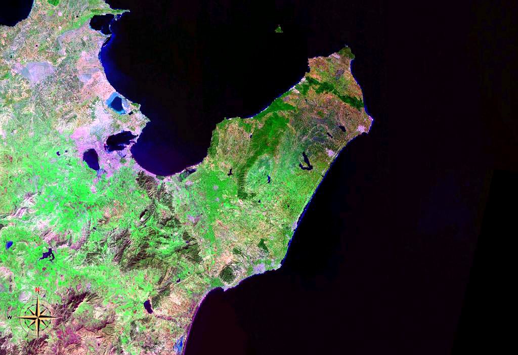 Cape Bon from space (false color) | |
 Location in Tunisia | |
| Coordinates: 36°45′N 10°45′E | |
| Location | Nabeul Governorate, Tunisia |
Peninsula

The peninsula's northern shore forms the southern end of the Gulf of Tunis, while its southern shore is on the Gulf of Hammamet.
The peninsula is administered as the country's Nabeul Governorate.
Settlements on the peninsula include Nabeul, Hammam el ghezaz, El Haouaria, Kelibia, Menzel Temime, Korba, and Beni Khalled. Rivers include the Melah and Chiba wadis. Mountains include Kef Bou Krim (237 m or 778 ft), Kef er-Rend (637 m or 2,090 ft), Djebel Sidi Abd er-Rahmane (602 m or 1,975 ft), Djebel Hofra (421 m or 1,381 ft), and Djebel Reba el-Aine (328 m or 1,076 ft). Besides Cape Bon, other headlands on the peninsula are Ras Dourdas and Ras el-Fortass on the northern shore, Ras el-Melah on the short eastern shore, and Ras Mostefa and Ras Maamoura on the southern shore.
The ruins of the Punic town Kerkouane are also located here. Djebel Mlezza ("Mt Mlessa") has tombs from the time of Agathocles,[4] which were excavated just before the First World War.
See also
- Battles of Cape Bon in 468 and in 1941
- El Brij, Tunisia
- Sidi Rais
- Korbous
References
- - Britannica Concise
- Sharīk Peninsula, Encyclopedia Britannica
- Shaw, Thomas (1757). Travels, Or Observations Relating to Several Parts of Barbary and the Levant: Illustrated with Cuts. A. Millar in the Strand, and W. Sandby in Fleet-Street. p. 76.
- Paul Lachlan MacKendrick, The North African Stones Speak (UNC Press Books, 1 Dec. 2000) p20.
Authority control | |
|---|---|
| General |
|
| National libraries | |
This Tunisia location article is a stub. You can help Wikipedia by expanding it. |
На других языках
[de] Kap Bon
Kap Bon (französisch Cap Bon; arabisch الرأس الطيب, DMG ar-Raʾs aṭ-ṭayyib oder رأس الدار / Raʾs ad-dār) ist eine im Nordosten Tunesiens gelegene Halbinsel, die in ihren Verwaltungsgrenzen dem Gouvernement Nabeul entspricht.- [en] Cape Bon
[es] Cabo Bon
El cabo Bon (en árabe, , كاب بون, o Eddar Rass) es un cabo y una península localizado en la costa septentrional de África, en aguas del mar Mediterráneo, en el extremo nororiental de Túnez. Es el extremo noroccidental del golfo de Túnez. En la península se encuentran las ciudades de Nabeul o Kélibia. Las ruinas de la ciudad púnica de Kerkouane también se encuentran aquí.[ru] Эт-Тиб
Эт-Тиб[1][2], ранее — Бон[3], также Рас-эль-Тиб (Кап-Бон)[4] (араб. الرأس الطيب) — самая близкая к Сицилии точка африканского побережья. Мыс Эт-Тиб, расположенный на северо-востоке Туниса, омывается водами Тунисского залива. От итальянской территории его отделяет Тунисский пролив.Другой контент может иметь иную лицензию. Перед использованием материалов сайта WikiSort.org внимательно изучите правила лицензирования конкретных элементов наполнения сайта.
WikiSort.org - проект по пересортировке и дополнению контента Википедии