geo.wikisort.org - Coast
Cap-Vert, or the Cape Verde Peninsula, is a peninsula in Senegal and the westernmost point of the continent of Africa and of the Afro-Eurasia mainland. Portuguese explorers called it Cabo Verde or "Green Cape". The Cape Verde islands, 570 kilometres (350 mi) further west, are named after the cape. Dakar, the capital of Senegal, occupies parts including its southern tip.[1]
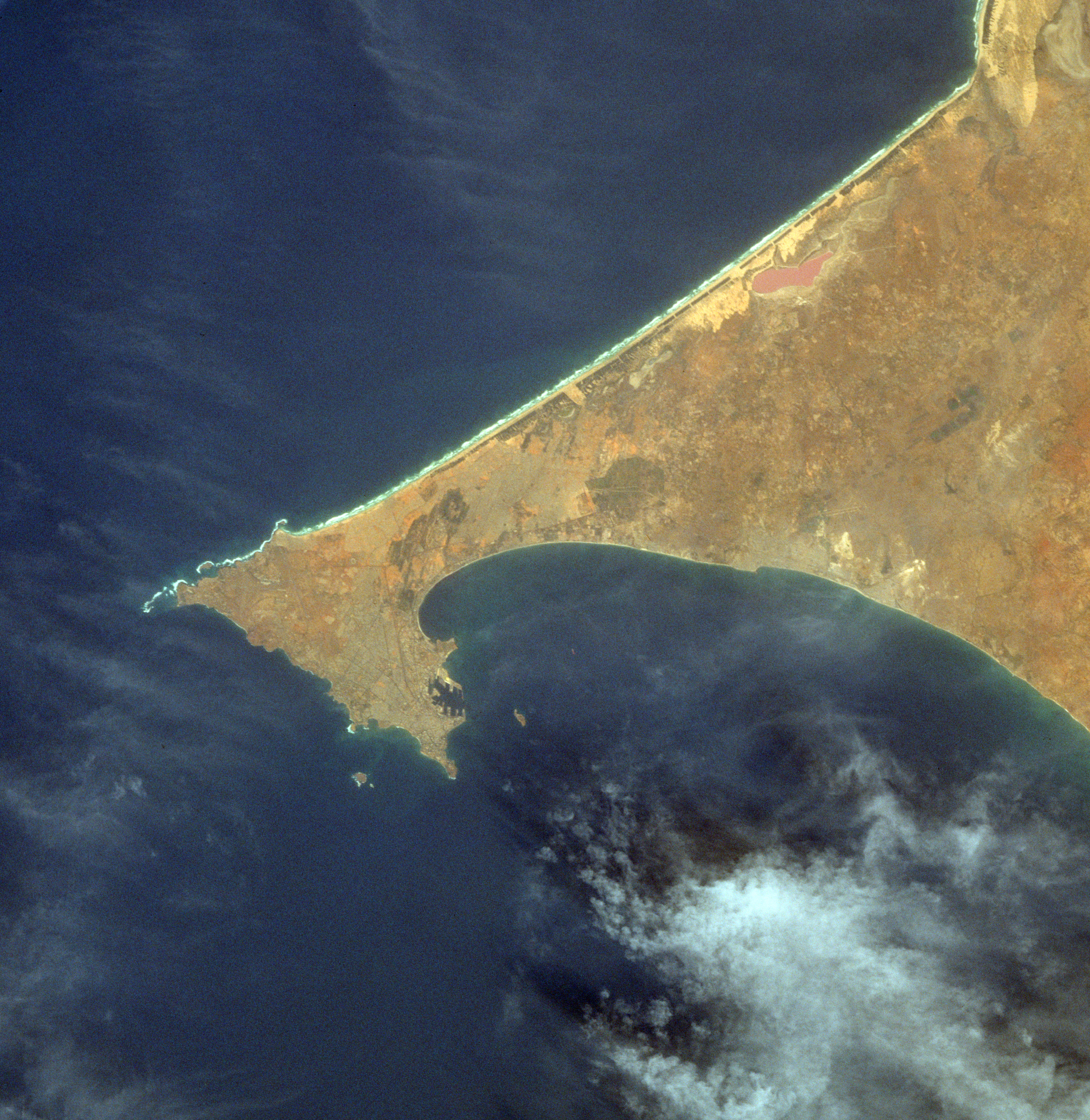
Formed by a combination of volcanic offshore islands and a land bridge produced by coastal currents, the cape projects into the Atlantic Ocean, bending back to the southeast at its tip. Exposure to southwesterly winds contributes to Cape Verde's seasonal verdant appearance, in contrast to the undulating yellow dunes to the north.
The peninsula is shaped like a triangle (about 9 miles (14 km) per side), with the base of the triangle roughly along the north and its apex on the south, near Dakar. Near Pointe des Almadies, the north-western tip of the cape, lies Léopold Sédar Senghor International Airport, which was used as a transatlantic ferrying point during World War II. Twin volcanic cones, the Deux Mamelles ("Two Teats"), dominate the landscape along the coast northwest of Dakar. The peninsula encloses a bay and a natural harbour in the southwest.
The indigenous inhabitants of the peninsula, the Lebou, lived as fishermen and farmers.[2] Since about 1444, when the Portuguese first sighted the cape, it has been an entrepôt for African-European trade. The French later established the city of Dakar on the cape in 1857.
References
- Roger J., Banton O., Barusseau J.-P., Castaigne P., Comte J.-C., Duvail C., Nehlig P., Noël B. J., Serrano O., Travi Y., Notice explicative de la cartographie multi-couches à 1/50 000 et 1/20 000 de la zone d’activité du Cap-Vert, Ministère des Mines, de l’Industrie et des PME, Direction des Mines et de la Géologie, Dakar, 245 p., 2009d.
- Armand-Pierre Angrand, Les Lébous de la presqu'île du Cap-Vert, Dakar, La Maison du Livre, 1951, 143 p.
External links
| Authority control |
|
|---|
This Senegal location article is a stub. You can help Wikipedia by expanding it. |
На других языках
[de] Cap Vert
Das Kap Vert (französisch Cap-Vert; wörtlich „Grünes Kap“) meint zum einen die westlichste Spitze Kontinentalafrikas, die bei 14° 45' nördlicher Breite und 17° 31' westlicher Länge liegt, zum anderen aber auch die ganze Kap-Vert-Halbinsel (presqu'île du Cap-Vert), auf der die Millionenstadt Dakar mit ihren Vorstädten als Metropole des Senegal liegt. Der westlichste Punkt des Kap Vert wird als Pointe des Almadies bezeichnet.[1] Das Kap bildet eine karge Halbinsel aus vulkanischem Gestein, die vielfach mit Flugsand überzogen ist und nur einer dünnen Pflanzenschicht Nahrung bietet.- [en] Cap-Vert
[es] Cabo Verde (península)
La península de Cabo Verde es la parte más occidental del continente africano. Se trata de un promontorio rocoso que se extiende desde las zonas arenosas de Senegal. Dakar, la capital de Senegal, se encuentra en el extremo de dicha península, contando con un excelente puerto marítimo emplazado frente a la isla de Gorea.[ru] Кап-Вер
Кап-Вер[1] (фр. Cap-Vert — зелёный мыс) — полуостров на африканском побережье Атлантического океана, в Сенегале. На полуострове находится самая западная точка континентальной Африки — мыс Альмади. На южной оконечности Кап-Вера расположен город Дакар, столица Сенегала.Другой контент может иметь иную лицензию. Перед использованием материалов сайта WikiSort.org внимательно изучите правила лицензирования конкретных элементов наполнения сайта.
WikiSort.org - проект по пересортировке и дополнению контента Википедии