geo.wikisort.org - Küste
Die Mitchell-Halbinsel ist eine felsige Halbinsel an der Budd-Küste des ostantarktischen Wilkeslands. Sie trennt südlich der Windmill-Inseln die O’Brien Bay im Osten von der Sparkes Bay im Westen.
| Mitchell-Halbinsel | ||
| Geographische Lage | ||
| ||
| Koordinaten | 66° 19′ 41″ S, 110° 32′ 52″ O | |
| Lage | Budd-Küste, Wilkesland, Ostantarktika | |
| Gewässer 1 | Drew Cove und Robertson-Kanal (Norden) | |
| Gewässer 2 | O’Brien Bay (Osten) | |
| Gewässer 3 | Sparkes Bay mit Bednarz Cove (Westen) | |
| Länge | 4 km | |
| Breite | 3 km | |
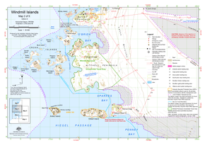 Karte der mittleren Windmill-Inseln mit der Mitchell Peninsula (Mitte) | ||

Erstmals kartiert wurde sie anhand von Luftaufnahmen der United States Navy im Februar 1947 während der Operation Highjump. Damals wurde sie irrtümlich für eine Insel gehalten, die über eine steile Schneerampe mit dem Kontinentaleis an der Budd-Küste verbunden ist. Ihre eigentliche Natur identifizierte die Mannschaft auf der Wilkes-Station im Jahr 1957. Das Advisory Committee on Antarctic Names benannte sie 1963 nach Ray A. Mitchell (1905–1987), Kapitän des Tankers USS Cacapon bei der Operation Highjump.
Weblinks
- Mitchell Peninsula im Geographic Names Information System des United States Geological Survey (englisch)
- Mitchell Peninsula auf geographic.org (englisch)
- Mitchell Peninsula im Composite Gazetteer of Antarctica (englisch)
- Karte der Windmill-Inseln und Umgebung (PDF, März 2009) beim Australian Antarctic Data Centre (Beschreibung)
На других языках
- [de] Mitchell-Halbinsel
[en] Mitchell Peninsula
Mitchell Peninsula (.mw-parser-output .geo-default,.mw-parser-output .geo-dms,.mw-parser-output .geo-dec{display:inline}.mw-parser-output .geo-nondefault,.mw-parser-output .geo-multi-punct{display:none}.mw-parser-output .longitude,.mw-parser-output .latitude{white-space:nowrap}66°20′S 110°32′E) is a rocky peninsula, 2.5 nautical miles (5 km) long and 2 nautical miles (4 km) wide, lying between O'Brien Bay and Sparkes Bay at the east side of the Windmill Islands, Antarctica. It was first mapped from aerial photographs taken by U.S. Navy Operation Highjump in February 1947 and thought to be an island connected by a steep snow ramp to the continental ice overlying Budd Coast, though the term peninsula was considered more appropriate by the Wilkes Station party of 1957. Mitchell Peninsula was named by the Advisory Committee on Antarctic Names for Captain Ray A. Mitchell, U.S. Navy, captain of the USS Cacapon, a tanker of the western task group of Operation Highjump, Task Force 68 of 1946–47.[1]Текст в блоке "Читать" взят с сайта "Википедия" и доступен по лицензии Creative Commons Attribution-ShareAlike; в отдельных случаях могут действовать дополнительные условия.
Другой контент может иметь иную лицензию. Перед использованием материалов сайта WikiSort.org внимательно изучите правила лицензирования конкретных элементов наполнения сайта.
Другой контент может иметь иную лицензию. Перед использованием материалов сайта WikiSort.org внимательно изучите правила лицензирования конкретных элементов наполнения сайта.
2019-2026
WikiSort.org - проект по пересортировке и дополнению контента Википедии
WikiSort.org - проект по пересортировке и дополнению контента Википедии