geo.wikisort.org - Küste
Der Bennett Dome ist eine an einen Eisdom erinnernde Halbinsel von 460 m Höhe auf der westantarktischen Alexander-I.-Insel. Sie liegt auf der Südseite der Beethoven-Halbinsel und trennt das Weber Inlet vom Boccherini Inlet.
| Bennett Dome | ||
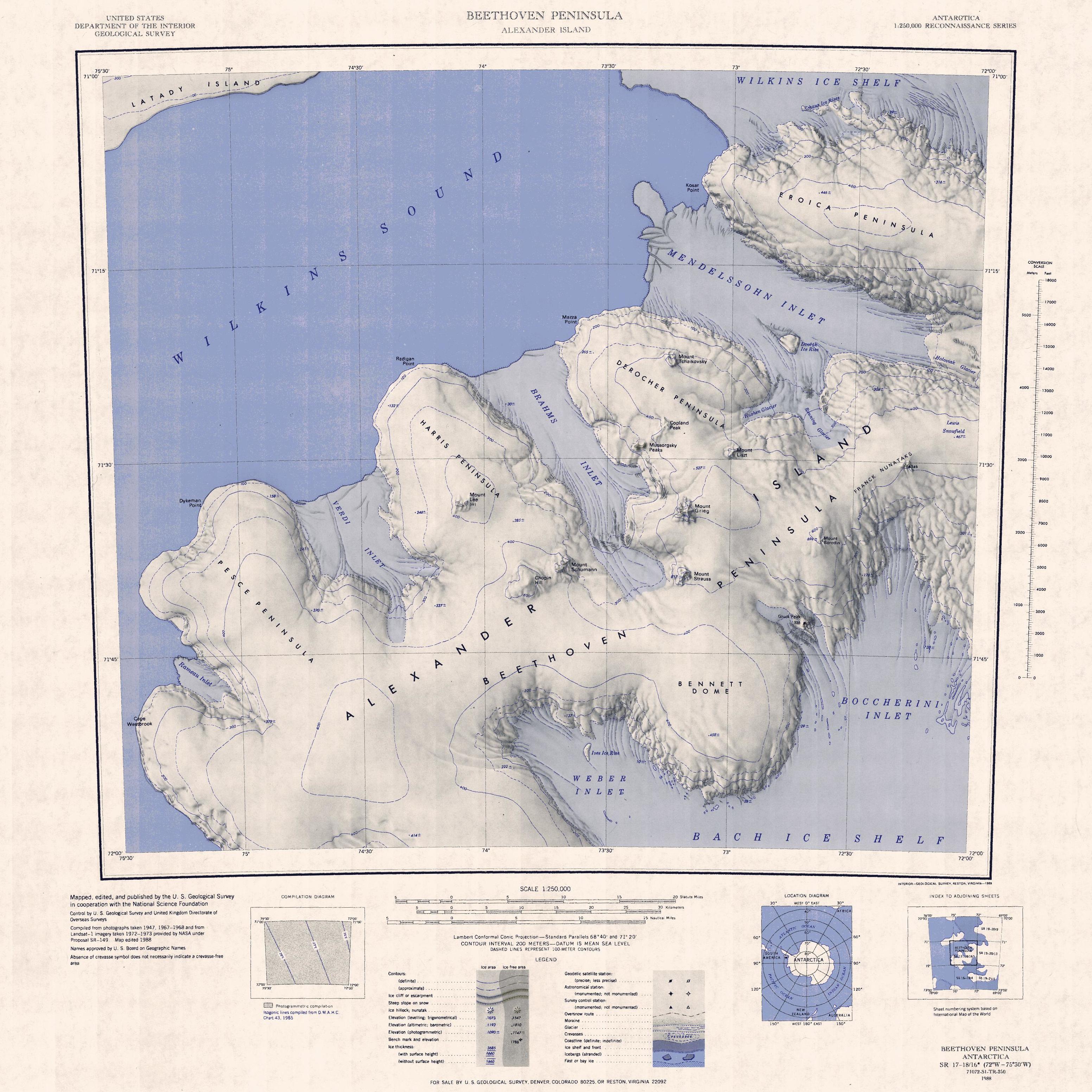 Topographisches Kartenblatt Beethoven-Halbinsel (1:250.000) mit dem Bennett Dome (unten rechts) | ||
| Geographische Lage | ||
| ||
| Koordinaten | 71° 48′ S, 73° 3′ W | |
| Lage | Alexander-I.-Insel, Westantarktika | |
| Küste | Beethoven-Halbinsel | |
| Gewässer | Weber Inlet | |
| Gewässer 2 | Boccherini Inlet | |

Der britische Geograph Derek Searle vom Falkland Islands Dependencies Survey kartierte sie 1960 anhand von Luftaufnahmen der US-amerikanischen Ronne Antarctic Research Expedition (1947–1948). Eine präzisere Ortsbestimmung nahm der United States Geological Survey mittels Luftaufnahmen der United States Navy aus den Jahren zwischen 1967 und 1968 sowie Landsataufnahmen von 1972 bis 1973 vor. Das Advisory Committee on Antarctic Names benannte die Halbinsel nach Joseph E. Bennett, Leiter der Sektion für polare Koorditantion und Information der Abteilung für das Polarprogramm der National Science Foundation von 1976 bis 1986.
Weblinks
- Bennett Dome im Geographic Names Information System des United States Geological Survey (englisch)
- Bennett Dome auf geographic.org (englisch)
На других языках
- [de] Bennett Dome
[en] Bennett Dome
Bennett Dome (.mw-parser-output .geo-default,.mw-parser-output .geo-dms,.mw-parser-output .geo-dec{display:inline}.mw-parser-output .geo-nondefault,.mw-parser-output .geo-multi-punct{display:none}.mw-parser-output .longitude,.mw-parser-output .latitude{white-space:nowrap}71°48′S 73°3′W) is a rounded snow-covered peninsula on the south side of Beethoven Peninsula, Alexander Island, Antarctica. rising to about 460 metres (1,500 ft) between Weber Inlet and Boccherini Inlet. It was photographed from the air by the Ronne Antarctic Research Expedition in 1947 and roughly mapped from the photographs by D. Searle of the Falkland Islands Dependencies Survey in 1960. It was mapped definitively by the United States Geological Survey from U.S. Navy aerial photographs taken 1967–68 and from Landsat imagery taken 1972–73, and named by the Advisory Committee on Antarctic Names for Joseph E. Bennett, the head of the Polar Coordination and Information Section, Division of Polar Programs, National Science Foundation, 1976–86.[1] Bennett Dome is one of the eight peninsulas of Alexander Island.Другой контент может иметь иную лицензию. Перед использованием материалов сайта WikiSort.org внимательно изучите правила лицензирования конкретных элементов наполнения сайта.
WikiSort.org - проект по пересортировке и дополнению контента Википедии