geo.wikisort.org - Fiume
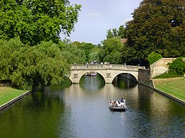
Il Cam è un fiume dell'Inghilterra orientale lungo 69,4 km, affluente in destra orografica del Great Ouse. I due fiumi si uniscono a sud di Ely, in località Pope's Corner. Il Great Ouse collega il Cam al sistema di canali dell'Inghilterra.
| Cam | |
|---|---|
 | |
| Stato | |
| Regioni | Cambridgeshire |
| Lunghezza | 69,4 km |
| Altitudine sorgente | 112 m s.l.m. |
| Altitudine foce | 2 m s.l.m. |
| Nasce | Sud di Debden 51°57′36.72″N 0°16′18.48″E |
| Sfocia | Great Ouse, presso Stretham 52°20′53.88″N 0°15′09″E |
Il Cam collega Cambridge con il Mare del Nord a King's Lynn, situata a circa 65 chilometri. Un'organizzazione chiamata Conservatori del fiume Cam (Conservators of the River Cam) fu fondata nel 1702, allo scopo di mantenere il fiume navigabile. I Conservatori sono responsabili delle tre chiuse a Cambridge e a nord est: Jesus Lock, Baits Bite Lock e Bottisham Lock. Il tratto a monte di Jesus Lock viene chiamato Top River (corso superiore), andando verso monte si passa per il Mill Pond, una diga, il Byron's Pool (dove si pensa Lord Byron facesse il bagno) ed il paese di Grantchester, dove i suoi rami sorgentiferi si uniscono. Il Top River è riservato alle punts (barche dal fondo piatto, simili alle gondole) ed al canottaggio. Il tratto tra Jesus Lock ed il Mill Pond comprende i Backs ed è la parte più apprezzata dai turisti grazie alle viste dei college. Il tratto a nord di Baits Bite Lock viene chiamato Lower River (corso inferiore).
Le squadre di canottaggio dei college utilizzano la porzione di fiume tra Jesus Lock e Bottisham Lock. Vi sono molte houseboats a Cambridge sul corso inferiore, alcune si spostano più a monte durante l'inverno.
In passato il Cam veniva chiamato Granta. Dopo che il nome della città anglo-sassone di Grantebrycge fu cambiato in Cambridge, il fiume fu rinominato di conseguenza.

I due tributari principali del Cam sono noti come Granta e Rhee, anche se sono entrambi ufficialmente chiamati Cam. Il Rhee nasce vicino ad Ashwell, nell'Hertfordshire e scorre per 20 km nelle campagne del Cambridgeshire meridionale. Il tributario più lungo, il Granta, nasce presso Widdington nell'Essex scorrendo per 25 km verso nord costeggiando l'Audley End House per unirsi al Rhee poco prima di Grantchester. Un altro tributario, anch'esso chiamato Granta, scorre per 15 km da Haverhill per unirsi al Granta principale a sud di Great Shelford, paese natale della scrittrice per bambini Philippa Pearce, i cui libri (Minnow on the Say il più famoso) rinominano il fiume Cam in fiume Say, Great e Little Shelford in Great e Little Barley e Cambridge in "Castleford" (da non confondersi con l'omonima città del West Yorkshire).
Un altro tributario minore è il Bourn Brook che nasce vicino ad Eltisley, 15 km ad ovest di Cambridge, attraversando Caxton, Bourn e Toft e sfociando nel Cam a Byron's Pool.
Altri progetti
 Wikimedia Commons contiene immagini o altri file su Cam
Collegamenti esterni
- Storia del fiume, su canals.btinternet.co.uk. URL consultato il 30 aprile 2019 (archiviato dall'url originale il 4 ottobre 2006).
- Conservators of the River Cam, su camconservators.org.uk.
- Guida al fiume a cura del First and Third Trinity Boat Club, su firstandthird.org. URL consultato l'11 maggio 2005 (archiviato dall'url originale il 19 marzo 2005).
| Controllo di autorità | VIAF (EN) 315530289 · WorldCat Identities (EN) viaf-315530289 |
|---|
На других языках
[de] River Cam (Great Ouse)
Der Cam ist ein Fluss in England, der südlich der Stadt Ely in die Great Ouse mündet und dadurch an das englische Kanalnetz angeschlossen ist.[en] River Cam
The River Cam (/ˈkæm/) is the main river flowing through Cambridge in eastern England. After leaving Cambridge, it flows north and east before joining the River Great Ouse to the south of Ely, at Pope's Corner. The total distance from Cambridge to the sea is about 40 mi (64 km) and is navigable for punts, small boats, and rowing craft. The Great Ouse also connects to England's canal system via the Middle Level Navigations and the River Nene. In total, the Cam runs for around 69 kilometres (43 mi) from its furthest source (near Debden in Essex) to its confluence with the Great Ouse.- [it] Cam (fiume)
[ru] Кам (река)
Кам (англ. Cam) — река в Великобритании, протекающая к югу от города Или и впадающая в Грейт-Уз. Длина реки — 69,4 км.[источник не указан 735 дней] Берёт начало к югу от Дебдена на высоте 112 м.Другой контент может иметь иную лицензию. Перед использованием материалов сайта WikiSort.org внимательно изучите правила лицензирования конкретных элементов наполнения сайта.
WikiSort.org - проект по пересортировке и дополнению контента Википедии